Agras T70P for Vineyard Survey Work: A Practical Field
Agras T70P for Vineyard Survey Work: A Practical Field Strategy for Complex Terrain
META: Expert guide to using the Agras T70P in steep, irregular vineyards, with practical insight on RTK accuracy, spray drift control, nozzle calibration, swath planning, and terrain-ready workflow.
Vineyard survey work looks tidy on a map. In the field, it rarely is.
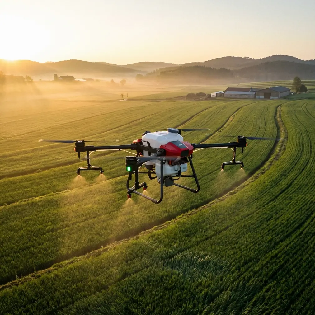
Rows bend with the hillside. Canopy density changes block by block. Wind behaves differently at the top of a slope than it does in a sheltered lower section. A drone that performs well over flat, open farmland can feel very different once it is asked to work above terraced vines, uneven headlands, and narrow access lanes. That is exactly where the Agras T70P deserves a more serious conversation.
The usual discussion around agricultural UAVs tends to stay broad: payload, efficiency, coverage. For vineyards in complex terrain, those talking points miss the real question. The issue is not whether the aircraft can fly. The issue is whether it can fly repeatable, data-informed, low-drift missions over irregular vineyard geometry while giving the operator enough confidence to make agronomic decisions block by block.
From that angle, the Agras T70P becomes interesting not simply as a spray platform, but as a field system that can support vineyard survey and precision treatment planning when configured carefully.
The problem in steep vineyards is not just topography
Steep or broken terrain introduces several operational problems at once.
First, you have elevation change. That affects route smoothness, height consistency above canopy, and how well the aircraft maintains intended application geometry across a row. In vineyard work, that geometry matters. A small shift in relative height can alter droplet behavior, deposition uniformity, and even the operator’s interpretation of canopy vigor if they are collecting supporting imagery in the same work cycle.
Second, vineyards are visually and structurally messy from an automation standpoint. Posts, wires, row gaps, headlands, shelterbelts, and adjacent tree lines complicate route design. Unlike broadacre operations, where swath width can often be treated as a straightforward efficiency variable, vineyards demand a more surgical approach. If swath planning is too aggressive, overlap suffers on curved rows and edge blocks. If it is too conservative, productivity falls and battery rotations increase.
Third, there is the issue that growers often underestimate until the first disappointing pass: spray drift. Vineyards sit near roads, waterways, neighboring crops, and sensitive boundaries. Terrain amplifies this problem because air movement over slopes and through row corridors can redirect droplets in ways that are hard to predict from a simple ground-level wind reading.
The Agras T70P is best understood as a response to these field realities, not as a generic “bigger is better” machine.
Why RTK performance changes the conversation
For vineyard survey and treatment planning, centimeter precision is not a luxury feature. It is the backbone of repeatability.
When operators talk about drone accuracy, they often focus on whether the aircraft can hold a position well enough to complete a mission. In vineyards, the more meaningful metric is whether the aircraft can return to the same spatial logic every time—same row alignment, same boundary behavior, same treatment corridor, same reference points for before-and-after comparison. That is where RTK fix rate matters in a practical sense.
A high RTK fix rate supports stable, repeatable line tracking in difficult geometry. In vineyards with broken sightlines or partial obstruction near trees and terrain edges, consistency in positioning determines whether one mission can be reliably compared with the next. If you are monitoring canopy variability or planning a targeted response to disease pressure, spatial drift between flights undermines the value of the dataset before agronomy even enters the discussion.
On the T70P, the operational significance is straightforward: better position fidelity means tighter route adherence and more trustworthy georeferencing across repeated passes. In a vineyard, that helps the operator maintain clean separation between productive rows, access lanes, and no-treatment zones. It also reduces the “close enough” mindset that leads to inconsistent application margins around irregular blocks.
For surveying work in particular, centimeter precision improves confidence when pairing the aircraft’s mission data with downstream farm maps, scouting notes, or zone-based treatment plans. The result is not abstract accuracy. It is fewer argument points between what the drone recorded and what the vineyard manager sees on the ground.
Swath width is a vineyard decision, not a brochure number
One of the most misunderstood setup choices in viticulture drone work is swath width.
On flat cereal ground, the temptation is to maximize width and chase efficiency. In vineyards, swath width should be chosen around row spacing, canopy shape, slope, and crosswind behavior. A number that looks efficient on paper can become expensive in the field if it creates uneven edge coverage or forces rework around corners and terraces.
The T70P gives operators the capacity to work larger areas, but the better practice in vineyards is often to deliberately restrain that capacity. Narrower, more controlled swath planning can produce better results in irregular blocks, especially where rows curve or where canopy height changes sharply within a single mission. This is a classic case where technical capability should not dictate agronomic strategy.
That matters even more when survey work is tied to treatment intent. If an operator is using field observations, prior imagery, or multispectral insights to define where intervention is needed, route quality matters more than nominal field speed. A well-calibrated mission with a disciplined swath can preserve canopy-specific intent. A wide, efficiency-first pass can blur the distinction between high-pressure and low-pressure zones.
The T70P is capable. The operator’s judgment is what turns that capability into useful vineyard work.
Nozzle calibration decides whether the aircraft is precise or merely impressive
Nozzle calibration is the quiet dividing line between a serious operation and a sloppy one.
Many drone operators are tempted to treat calibration as a pre-flight checkbox. In vineyards, it deserves more respect than that. Canopy density varies significantly between young blocks, mature vines, stressed sections, and heavily vegetative rows. Terrain adds another variable because relative aircraft height and airflow interaction can shift from one section to the next.
Calibration on a platform like the T70P should reflect actual vineyard conditions, not default assumptions. That includes nozzle selection, flow verification, droplet profile, intended travel speed, and the interaction between these variables and the canopy target. If the mission objective includes minimizing spray drift while maintaining penetration into a dense vine wall, then calibration is not a static setting. It is the operational expression of the agronomic goal.
This is where the T70P’s utility becomes more sophisticated than raw output. A machine with enough capacity to cover demanding blocks still has to be tuned for the biological target. In vineyards, being slightly wrong is often not slightly wrong. It can mean under-treating inner canopy zones, overshooting row edges, or increasing off-target movement near sensitive boundaries.
Operators who survey vineyards before treatment planning should view nozzle calibration as part of the same decision chain as mapping and route design. These are not separate tasks. They are linked stages in a single precision workflow.
Spray drift control is where complex terrain exposes weak operating habits
If there is one field condition that punishes shortcuts in vineyards, it is drift.
Slope-driven airflow, row-channel wind movement, and sudden exposure at ridge edges all make vineyards more sensitive than open paddocks. The T70P can help reduce operational inconsistency, but no aircraft can rescue a poor drift strategy.
The practical approach is to combine terrain-aware flight planning with conservative operating thresholds and verified calibration. In real-world vineyard work, this usually means avoiding the urge to fly simply because conditions are technically manageable. It means planning around row direction relative to wind, recognizing where terrain funnels air, and adjusting mission design where block edges border roads or neighboring plantings.
This is also where an IPX6K-rated airframe matters more than it first appears. In vineyard operations, field conditions are rarely pristine. Dust, residue, moisture, and repeated washdown cycles are part of the working environment. An IPX6K protection rating supports more robust field use and cleanup routines, which is not glamorous but is operationally important. Equipment that is easier to keep serviceable in harsh agricultural conditions tends to stay more reliable over a full season. In complex terrain, where downtime can derail narrow weather windows, that resilience matters.
The significance is practical: reliable hardware supports disciplined workflow. Disciplined workflow reduces drift risk.
A third-party multispectral setup can turn the T70P into a smarter vineyard tool
The most interesting field improvement I have seen with aircraft in this class did not come from the drone alone. It came from a third-party accessory.
For vineyard survey work, a compact third-party multispectral kit mounted as a complementary scouting solution can materially improve decision quality before any treatment mission is launched. The point is not to transform the T70P into a dedicated mapping drone. The point is to strengthen the decision chain around it.
In complex vineyards, visual assessment from the ground often misses early spatial patterns. Stress can appear in small elevation-related pockets. Drainage variation can alter vigor row by row. Disease pressure may present as subtle canopy differences before it becomes obvious from the headland. A multispectral layer helps expose those patterns with more consistency than ad hoc field notes alone.
That matters because the T70P is most valuable when it is used selectively and intelligently. A third-party multispectral accessory can help identify where lower vigor, water stress, or emerging variability justifies closer inspection or a targeted intervention strategy. It also provides a stronger basis for mission segmentation. Instead of treating a complex block as one agronomic unit, the operator can divide it into zones that reflect actual canopy behavior.
For readers who are building a vineyard workflow rather than buying a piece of hardware in isolation, this is the key shift. The drone is not the whole system. The system is aircraft, positioning, calibration, environmental judgment, and data context working together.
If you are evaluating how this kind of setup fits your own site conditions, this vineyard drone workflow chat is a useful place to compare terrain and mission assumptions before committing to a field plan.
A practical problem-solution workflow for the T70P in vineyards
The most effective way to use the Agras T70P in complex vineyard terrain is to stop thinking in terms of “one drone, one mission.”
The problem is variability. Terrain, canopy, airflow, and row geometry all vary more than broadacre workflows assume.
The solution is staged precision.
Start with block segmentation. Separate terraces, ridge sections, sheltered lower slopes, and irregular headlands into distinct operational zones. Do not let one flight plan carry too many terrain types if it forces compromise.
Then verify RTK performance before mission execution. A strong RTK fix rate is central to repeatability, especially if you intend to compare survey observations over time or maintain strict treatment boundaries. If positioning integrity is unstable, the rest of the workflow becomes less trustworthy.
Next, set swath width for the vineyard, not for maximum throughput. In curved or irregular row systems, controlled overlap usually outperforms aggressive coverage claims. This single decision often improves consistency more than operators expect.
After that, calibrate nozzles for the actual canopy target and weather window. Not the average vineyard. Not the previous farm. The block in front of you, under the conditions you have now. That is how drift reduction and deposition quality become achievable instead of aspirational.
Finally, where available, bring in multispectral context or other scouting data to separate symptom from pattern. The T70P works best when it operates from informed intent rather than routine repetition.
What the Agras T70P really offers vineyard operators
The Agras T70P is not interesting because it promises abstract precision. Many platforms promise that.
It is interesting because, in complex vineyard terrain, it can support a disciplined operator who needs repeatable path control, practical environmental durability, and enough mission flexibility to adapt to real block variability. The operational details matter: RTK fix rate for repeatability, swath width discipline for irregular geometry, nozzle calibration for biological relevance, and IPX6K durability for season-long field use.
Add a thoughtful third-party multispectral workflow, and the aircraft becomes more than a treatment tool. It becomes part of a more mature vineyard decision system.
That is the standard worth aiming for. Not bigger numbers. Better field judgment, expressed through better setup.
Ready for your own Agras T70P? Contact our team for expert consultation.