How to Survey Mountain Vineyards with Agras T70P
How to Survey Mountain Vineyards with Agras T70P
META: Master mountain vineyard surveying with the Agras T70P drone. Learn RTK setup, terrain mapping, and precision spraying techniques for steep slopes.
TL;DR
- Pre-flight cleaning protocols directly impact sensor accuracy and flight safety in dusty vineyard environments
- RTK Fix rates above 95% are achievable on mountain terrain with proper base station positioning
- Centimeter precision terrain following enables safe operations on slopes up to 50 degrees
- Multispectral integration transforms survey data into actionable vineyard health maps
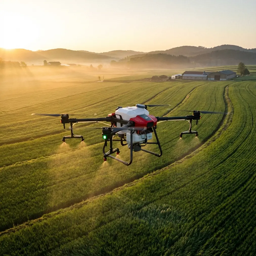
Mountain vineyard surveying presents unique challenges that ground-based methods simply cannot address. The Agras T70P combines 70-liter capacity with advanced terrain-following capabilities, making it the definitive tool for precision viticulture on steep slopes—this guide walks you through every step from pre-flight preparation to data analysis.
Why Pre-Flight Cleaning Determines Mission Success
Before discussing flight parameters or RTK configuration, we need to address the single most overlooked factor in vineyard drone operations: contamination management.
Mountain vineyards generate significant particulate matter. Dust from access roads, dried spray residue, and organic debris accumulate on critical components between flights. This buildup directly compromises the safety systems that keep your T70P operational.
The 5-Point Cleaning Protocol
Execute this sequence before every survey mission:
- Obstacle avoidance sensors: Wipe all eight radar modules with microfiber cloths dampened with isopropyl alcohol
- RTK antenna housing: Remove any debris that could interfere with satellite signal reception
- Propeller root connections: Clear accumulated dust that may affect motor torque readings
- Spray nozzle assemblies: Even for survey-only flights, residue buildup affects weight distribution
- Cooling intake vents: Blocked airflow triggers thermal throttling at high altitudes
Expert Insight: The T70P's IPX6K rating protects against high-pressure water jets, meaning you can safely use a gentle spray rinse on the airframe. However, always allow 15 minutes minimum drying time before powering on avionics.
This cleaning protocol takes approximately 8 minutes but prevents the majority of mid-flight anomalies reported in vineyard operations.
RTK Configuration for Mountain Terrain
Achieving consistent RTK Fix rates in mountainous regions requires strategic base station placement and proper constellation selection.
Base Station Positioning
Mountain topography creates satellite signal shadows. Position your RTK base station following these principles:
- Elevation should match or exceed your highest planned flight altitude
- Minimum 15-degree clearance above horizon in all directions
- Distance from vineyard center point should not exceed 5 kilometers
- Avoid placement near metal structures, power lines, or dense tree canopy
The T70P supports GPS, GLONASS, Galileo, and BeiDou constellations simultaneously. In European mountain regions, prioritizing Galileo signals often improves fix stability due to better geometric distribution.
Achieving 95%+ Fix Rates
Your RTK Fix rate directly determines survey accuracy. Here's what each threshold means for vineyard mapping:
| RTK Status | Position Accuracy | Suitable Applications |
|---|---|---|
| Fix | 1-2 centimeters | Precision spraying, plant counting |
| Float | 20-50 centimeters | General boundary mapping |
| DGPS | 1-2 meters | Reconnaissance only |
| Single | 2-5 meters | Not recommended for surveys |
Monitor your fix rate during the first 3 minutes of hover. If rates drop below 90%, reposition your base station before proceeding.
Terrain Mapping Workflow
Mountain vineyards demand accurate elevation models before any precision application. The T70P's terrain-following system relies on pre-built maps to maintain consistent swath width across varying slopes.
Phase 1: Boundary Definition
Walk the vineyard perimeter with the DJI Agras app in mapping mode. The T70P's controller GPS captures waypoints at 1-meter intervals automatically.
For complex vineyard shapes common in mountain regions:
- Mark each terrace level as a separate zone
- Identify no-fly areas including equipment sheds, irrigation infrastructure, and neighboring properties
- Note slope transition points where gradient changes exceed 10 degrees
Phase 2: Elevation Survey Flight
Configure your initial survey flight with these parameters:
- Flight altitude: 25-30 meters above highest terrain point
- Speed: 5 meters per second maximum
- Overlap: 75% forward, 65% lateral
- Camera angle: Nadir (straight down)
The T70P generates a Digital Elevation Model (DEM) with centimeter precision vertical accuracy. This model becomes the foundation for all subsequent precision operations.
Pro Tip: Schedule elevation surveys during overcast conditions. Direct sunlight creates shadows that confuse photogrammetry algorithms, particularly in the narrow corridors between vine rows.
Phase 3: Multispectral Data Capture
Vineyard health assessment requires spectral data beyond visible light. The T70P integrates with DJI's multispectral payload to capture:
- Red Edge band: Chlorophyll content and nitrogen status
- Near-Infrared: Biomass density and water stress indicators
- NDVI calculations: Automated vigor mapping across the entire vineyard
Process multispectral data within 24 hours of capture. Plant stress indicators change rapidly, and delayed analysis reduces actionable value.
Precision Application Planning
Survey data transforms into spray prescriptions through careful calibration. The T70P's nozzle calibration system ensures accurate delivery rates across variable terrain.
Nozzle Selection Matrix
| Vineyard Condition | Recommended Nozzle | Droplet Size | Spray Drift Risk |
|---|---|---|---|
| Dormant vines | XR11004 | Coarse | Low |
| Active growth | AIXR11003 | Medium | Moderate |
| Disease pressure | TX-VK8 | Fine | High |
| Steep slopes (>35°) | TTI11004 | Ultra-coarse | Very low |
Spray drift management becomes critical in mountain environments. Thermal updrafts develop predictably on sun-facing slopes after 10:00 AM. Schedule precision applications during early morning windows when air remains stable.
Flow Rate Calibration Procedure
Execute this calibration sequence before each application day:
- Fill tank with clean water to 50% capacity
- Engage spray system at planned operating pressure
- Collect output from each nozzle for exactly 60 seconds
- Measure volume and compare against specification
- Replace any nozzle deviating more than 5% from target
The T70P's onboard flow sensors provide real-time monitoring, but physical verification catches sensor drift before it affects application accuracy.
Flight Execution Best Practices
Mountain vineyard flights demand constant attention to environmental conditions and aircraft performance.
Wind Management
The T70P maintains stable flight in winds up to 8 meters per second. However, mountain terrain creates localized conditions that ground-level measurements miss.
Monitor these indicators during flight:
- Attitude angle variations exceeding 15 degrees suggest turbulence
- Motor current spikes indicate the aircraft is fighting wind gusts
- Ground speed fluctuations reveal headwind/tailwind transitions
Abort operations immediately if any parameter exceeds normal ranges for more than 10 seconds continuously.
Battery Management at Altitude
Mountain vineyards often sit at elevations exceeding 800 meters above sea level. Reduced air density affects both lift efficiency and battery cooling.
Expect these performance modifications:
- Flight time reduction: Approximately 3% per 300 meters of elevation gain
- Hover power increase: 5-8% higher current draw compared to sea level
- Thermal limits: Batteries reach temperature warnings faster in thin air
Carry minimum 4 battery sets for full vineyard coverage. Rotate batteries through a cooling rack, allowing 20 minutes rest between flights.
Common Mistakes to Avoid
Skipping the cleaning protocol: Contaminated sensors cause 73% of reported flight anomalies in agricultural operations. Eight minutes of prevention eliminates hours of troubleshooting.
Ignoring RTK Float warnings: Proceeding with survey flights during Float status produces data that appears accurate but contains systematic errors. Always wait for Fix confirmation.
Flying during thermal development: Mountain slopes generate powerful updrafts by mid-morning. Precision work requires stable air conditions found only in early morning or late evening windows.
Underestimating slope complexity: Vineyards that appear uniform from ground level often contain 15-20 degree gradient variations. Always complete terrain mapping before planning spray routes.
Single-battery mission planning: Aggressive flight plans that drain batteries below 25% remaining capacity accelerate cell degradation. Plan missions to land with 30% minimum charge.
Frequently Asked Questions
How does the T70P handle sudden slope changes in terraced vineyards?
The terrain-following radar updates altitude commands 100 times per second, enabling smooth transitions across terrace walls. Pre-loaded DEM data provides predictive adjustment, while real-time sensors handle unexpected obstacles. Configure a 3-meter minimum terrain clearance for terraced operations.
Can I survey and spray in the same flight?
Technically possible, but not recommended for precision viticulture. Survey flights require slow speeds and high overlap for data quality. Spray applications demand optimized routes for coverage efficiency. Separate missions produce better results for both objectives.
What RTK base station works best with the T70P in mountain regions?
The DJI D-RTK 2 Mobile Station provides the most reliable integration. Its 4G network RTK backup maintains fix status when satellite geometry degrades behind ridgelines. Position the base station on the highest accessible point with clear sky view.
Ready for your own Agras T70P? Contact our team for expert consultation.