Agras T70P in the Mountains: A Field Report on Power Line
Agras T70P in the Mountains: A Field Report on Power Line Survey Work, Sensor Judgment, and Why Spectral Data Matters
META: Field report on using the Agras T70P for mountain power line surveying, with insights on centimeter precision, RTK fix reliability, multispectral soil intelligence, and real-world sensor performance.
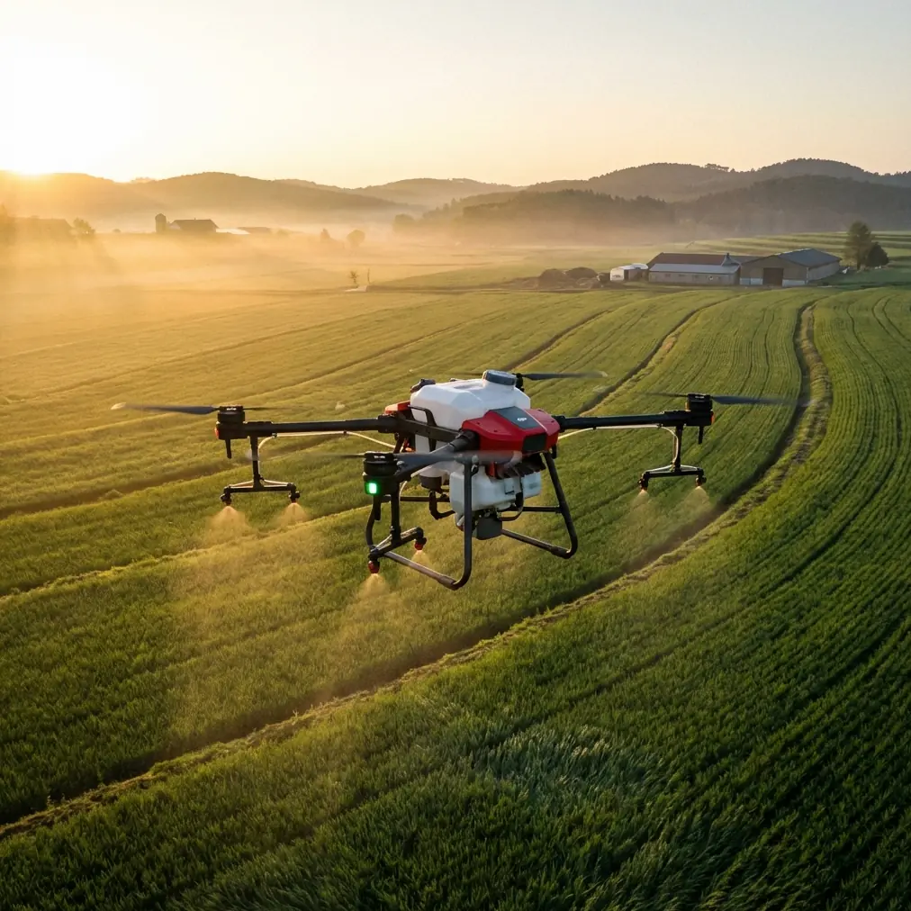
The Agras T70P is usually discussed through the narrow lens of agricultural spraying. That misses something bigger. In difficult terrain, especially along mountain power corridors, the platform becomes a test of flight stability, navigation confidence, environmental awareness, and data discipline. This field report looks at the T70P from that angle: not as a brochure item, but as a working aircraft asked to fly where the ground rises fast, visibility changes by the minute, and every line span creates its own wind behavior.
Our team’s assignment was straightforward on paper: survey power lines crossing steep agricultural hillsides, document vegetation pressure near the corridor, and collect supporting terrain observations that could later guide treatment planning and site management. On the ground, it was less tidy. The route stitched together orchards, terraced soil, access tracks cut into the slope, and several exposed ridges where wind curled back upslope in uneven bursts.
That is where the Agras T70P either earns trust or doesn’t.
Why the mountain environment changes what matters
A mountain power line survey is not simply a flat-land inspection moved uphill. Terrain compresses reaction time. Trees rise into the flight envelope more abruptly. GNSS conditions can vary as the aircraft moves between open ridges and narrow side slopes. Moisture, dust, and splash are not theoretical either, especially when operations involve mixed agriculture and rough access roads.
This is why details such as RTK fix rate, centimeter precision, and weather-hardened construction are not throwaway specifications. In this kind of work, they shape whether the drone can repeatedly hold the same corridor geometry and generate usable comparisons between one flight and the next.
For line-side operations, repeatability matters more than many new operators expect. A single clean pass is useful. A repeatable pass, aligned closely enough to compare vegetation encroachment, terrain change, or trouble spots over time, is where the aircraft becomes operationally valuable. That is the practical meaning of centimeter-level positioning in the field: not abstract precision, but dependable revisits.
The wildlife moment that tested the sensors
One section of the route crossed a wooded ravine before opening into a narrow bench under the conductors. Midway through that transition, a pair of muntjac deer broke from cover and moved uphill below the aircraft. At almost the same time, a large bird lifted from a dead pine near the corridor edge and cut across the line of travel.
That brief sequence forced an immediate judgment call. In mountain survey work, wildlife is not rare background scenery. It is part of the operating environment. The T70P’s sensing and route awareness helped us hold separation, pause the advance, and reset the path without overcorrecting into the slope or drifting toward the structures. The value of onboard sensing becomes very obvious in moments like this. You are not just avoiding branches or poles. You are managing a living environment where sudden movement can appear from below, beside, or above the route.
This matters for civilian utility and agricultural work because it reduces unnecessary disturbance and lowers the chance of rushed pilot inputs. In difficult terrain, smooth intervention is safer than dramatic intervention.
The hidden overlap between power line surveying and agricultural intelligence
At first glance, a mountain utility corridor and an agronomy workflow seem unrelated. In reality, they overlap more than people think. The same flight often passes over cropland, exposed soil, runoff channels, and managed vegetation. That creates a chance to capture more than visual documentation.
This is where the reference material on hyperspectral remote sensing becomes relevant. Traditional remote sensing, according to the source data, often uses band widths in the 100–200 nm range, and that broadness causes loss of detail useful for identifying ground features. In practical terms, that means wide bands can miss subtle spectral distinctions that matter when you want to understand soil condition rather than just produce a pretty image.
The source also points to a more targeted spectral approach: a normalized spectral index built from 550 nm and 450 nm can estimate soil total nitrogen effectively, while other researchers identified a nitrogen absorption region around 510 nm, though soil type strongly affects results. This is not just an academic footnote. It has direct operational significance for mountain corridor management.
Why? Because slopes under and near power lines are often managed as a vegetation-control zone. If crews later need to decide where revegetation is weak, where soil recovery is uneven, or where nutrient status may be contributing to poor ground cover and erosion risk, a drone workflow informed by narrow-band or multispectral logic becomes far more useful than generic aerial imagery. The survey mission can become the foundation for better land stewardship around utility assets.
What the spectral research means for an Agras T70P operator
The most important lesson from the reference data is not that one index solves everything. It is the opposite. Soil models are highly local. One cited study established models across 5 different soil types and different depths, then found that a model built in one region has significant limitations when used for soil samples from another region. Another result showed a correlation above 0.90 between spectral prediction and chemical measurement in one modeling approach, while other methods produced different accuracy levels.
For a T70P operator working in mountain environments, this has a practical consequence: if you are collecting imagery or planning to pair the aircraft with multispectral workflows, do not assume a universal agronomic model travels cleanly from one valley to the next. The terrain may look similar. The soil may not be.
That is exactly why field teams should combine aerial data with local ground truth instead of treating remote sensing outputs as final truth. The drone can scale observation. It cannot erase environmental variability.
A good corridor survey in agricultural mountains therefore has two layers:
- Reliable spatial capture of the route itself, helped by stable positioning and route repeatability.
- Localized interpretation of surrounding land condition, using spectral logic that respects soil differences.
That second layer is where many operations either become more intelligent or drift into overconfidence.
The old sampling problem is still real
The source material also highlights a problem every rural utility and ag-tech team knows too well: field sampling is expensive, slow, and locked to a moment in time. Soil heavy metal monitoring done by ground collection and chemical analysis can be very accurate on a small scale, but the document notes major limits from spatial heterogeneity and sampling cost. Repeated, wide-area collection demands significant labor and materials, and fast periodic sampling is difficult.
In mountain corridors, those limits are amplified. Some sections are hard to access by vehicle. Others involve steep foot movement or fragmented plots owned by different parties. A drone does not replace lab testing. But it can reduce blind spots and help target where deeper investigation actually belongs.
That is a critical distinction. Aircraft like the Agras T70P are most valuable when they sharpen decision-making before crews commit time, people, and instruments on the ground.
Spray drift and nozzle calibration still belong in this discussion
Even though this mission centered on surveying power lines, it would be a mistake to ignore the T70P’s agricultural identity. In mixed-use mountain areas, survey findings often feed directly into treatment plans for vegetation control, foliar applications, or rehabilitation work on nearby parcels. That is where spray drift and nozzle calibration become operationally relevant.
Around energized corridors and mountain crosswinds, application quality is shaped by far more than tank volume. Drift risk changes with slope-generated airflow, tree-channeling effects, and thermal movement along exposed ridges. Nozzle calibration becomes the bridge between a route map and a workable treatment outcome. If the aircraft later returns for vegetation management, the survey flight should already have identified the sections where swath behavior may narrow, overlap may increase, or drift risk may rise near towers and edge vegetation.
This is another reason repeatable line work matters. A stable survey route can reveal where the topography itself will complicate future spray geometry.
The AI and training angle nobody should overlook
One of the supporting references focuses on UAV education and notes that AI development has advanced through decades of progress, now showing traits such as human-machine collaboration and autonomous control after more than 60 years of evolution. It also outlines a structured learning path in which students progress from model aircraft principles to quadcopter fundamentals, including GPS, gyroscopes, and accelerometers.
That educational framing actually fits the T70P story well. Mountain utility work punishes shallow understanding. Operators who only know button sequences struggle when the aircraft is forced into terrain-driven edge cases. Operators who understand navigation modules, sensor behavior, aircraft attitude, and mission logic make better decisions under pressure.
The drone industry has spent too much time pretending advanced platforms eliminate the need for advanced operators. They don’t. They redistribute the skill requirement. Instead of hand-flying every detail, crews now need stronger judgment about mission design, sensor interpretation, route safety, environmental effects, and data validity.
If your team is developing a T70P workflow for utility-adjacent agriculture or mountain land management, that training mindset matters as much as the aircraft itself. If you want to compare deployment notes or field setup choices, this Agras T70P field workflow chat is a practical place to continue the discussion.
What stood out most from the mountain survey
Three things became obvious by the end of the day.
First, the T70P’s value in mountain line work is tied to how calmly it handles complexity. That includes route repeatability, obstacle awareness, and the ability to stay composed when the terrain keeps changing the visual picture. The deer-and-bird encounter was a reminder that not every obstacle is static, and not every safe correction can wait.
Second, centimeter-class positioning is not a vanity metric in these environments. It underpins consistent revisits, cleaner corridor comparisons, and more disciplined treatment planning. When operators talk about RTK fix rate, they are really talking about confidence: confidence that this flight matches the previous one closely enough to support decisions instead of guesswork.
Third, the spectral science behind land assessment deserves more respect in utility-adjacent drone operations. The reference facts show why broad-band remote sensing can miss useful information and why narrower spectral relationships around 450 nm, 550 nm, and about 510 nm can matter for nitrogen estimation. They also warn that soil type can break the portability of a model. That combination—strong promise, strong limits—is exactly the kind of nuance experienced operators should embrace.
A more useful way to think about the Agras T70P
The easy way to frame the Agras T70P is as a spray aircraft with rugged hardware. The more accurate way is to see it as part of a field intelligence system. In mountain power line scenarios, that system includes navigation precision, terrain reading, sensor-aided avoidance, environmental restraint, and the ability to connect aerial observations with agronomic reality.
That broader view is where the aircraft becomes genuinely useful.
It can help a team document corridor conditions with repeatable geometry. It can support surrounding land analysis where erosion, vegetation stress, or nutrient imbalance may shape longer-term maintenance. It can reduce unnecessary foot access into steep or fragmented areas. And when paired with proper local calibration, it can sit upstream of better decisions instead of simply generating more images.
For crews working in mountains, that is the standard worth aiming for. Not just flying. Knowing what the flight means.
Ready for your own Agras T70P? Contact our team for expert consultation.