Agras T70P in Mountain Forest Operations
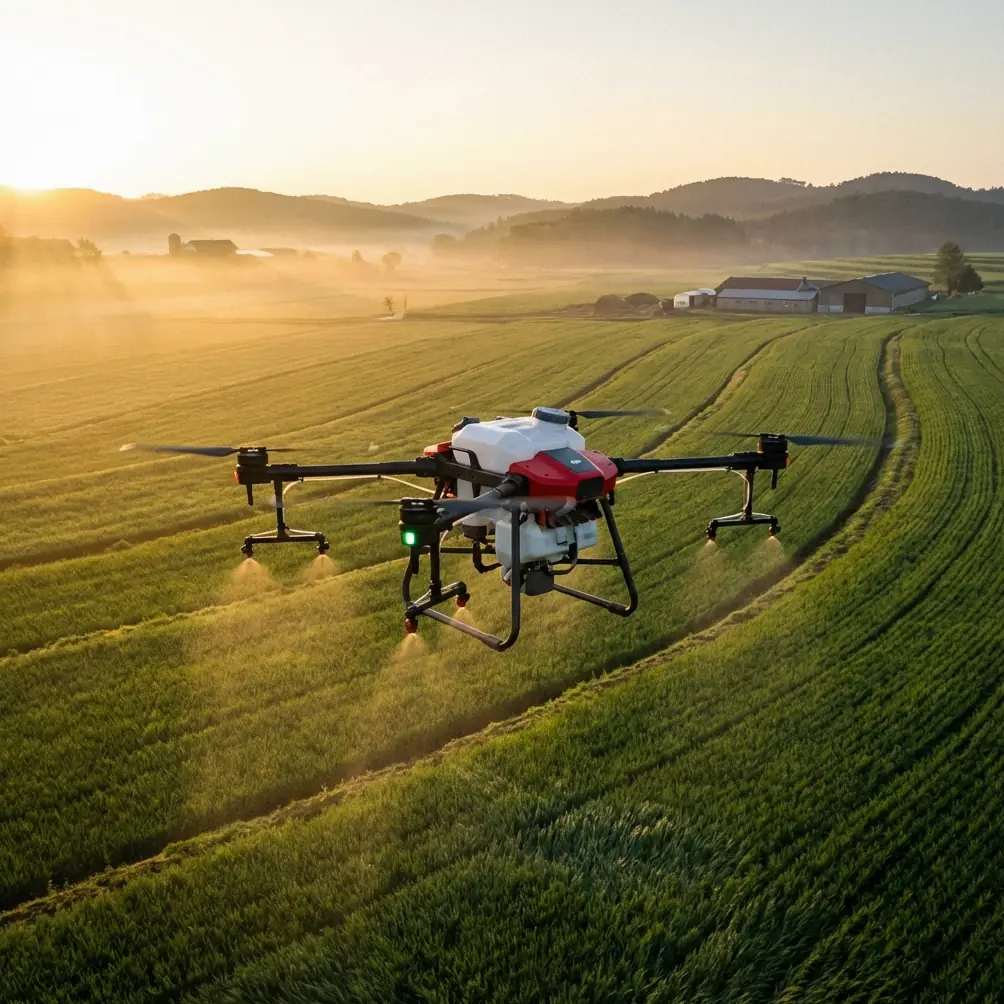
Agras T70P in Mountain Forest Operations: What Actually Matters in the Field
META: A technical review of the Agras T70P for mountain forest surveying and precision field work, with practical insight on control stability, RTK precision, spray discipline, and operator workflow.
The first time I was asked to evaluate a large drone platform for work near steep forested terrain, the challenge was not lift capacity or headline specs. It was control discipline.
Mountain environments exaggerate every weakness in a UAV workflow. Wind bends around ridgelines. Canopy edges create abrupt turbulence. GNSS quality shifts as the aircraft moves from open clearings into areas bordered by trees and rock. If the mission also includes agricultural assessment or precision treatment around forest margins, small errors turn into drift, overlap, wasted liquid, and patchy coverage.
That is the lens I would use for the Agras T70P.
This is not a machine you judge by brochure language. You judge it by whether it can hold a predictable path, maintain repeatable output, and stay useful when the job site is nowhere near a flat open farm. For crews surveying forests in mountain regions, those questions are more practical than any spec sheet summary.
Why the T70P matters beyond agriculture
The interesting shift in the drone industry is that heavy-duty platforms are no longer seen only as farm tools. A recent Shenzhen report described drones becoming “airborne first responders,” folded directly into public services and everyday city life. That matters because it reflects a broader truth: low-altitude systems are being valued less as abstract technology and more as dependable operational infrastructure.
The Agras T70P sits inside that same evolution.
Even if your immediate task is mountain forest surveying, vegetation health observation, boundary mapping support, or precision treatment on adjacent managed land, the real value is not just payload capability. It is whether the aircraft can become part of a repeatable field system. The Shenzhen example is useful here because it shows what separates a serious UAV platform from a novelty: reliability, deployment speed, and the ability to fit into real-world workflows where people are depending on the result.
For mountain forestry work, that means the T70P has to be evaluated as a working instrument, not merely a spray drone.
My past frustration with mountain jobs
A few years ago, a client asked for support on a mixed terrain property where plantation sections bordered unmanaged forest. The mission sounded straightforward: inspect access corridors, document canopy variation, identify stressed vegetation, and prepare for targeted treatment in specific edge zones. In reality, the site punished every weak habit.
We dealt with three recurring issues:
- inconsistent path tracking near slopes
- variable output once wind shifted across the swath
- operator fatigue from constantly correcting for terrain and canopy effects
That experience changed how I review aircraft like the Agras T70P. I now care less about broad claims and more about the mechanics behind stable control, accurate navigation, and nozzle behavior under changing conditions.
The control question most buyers overlook
One of the most useful technical references in your source set is not even from an agricultural drone brochure. It comes from the BLHeli motor control documentation, which explains a simple but operationally critical concept: in closed loop mode, throttle input is not just a raw power command. It sets an RPM target for the motor, and the control system then works to maintain that speed. The document also states that the high-range mode maps throttle from 0% to 100% linearly to 0 to 200000 electrical RPM, with middle and low ranges capped at 100000 and 50000 electrical RPM respectively.
Why does that matter when discussing the Agras T70P in mountain forest work?
Because stable rotor speed behavior is one of the hidden foundations of flight consistency. On uneven terrain, the aircraft is constantly responding to subtle disturbances. If the propulsion control architecture is poor, the pilot sees it as wobble, lag, height inconsistency, or unpredictable transition behavior when the aircraft meets a gust at the edge of a treeline. A machine designed around disciplined motor-speed regulation is better positioned to keep attitude changes under control and hold a cleaner line.
That does not mean the T70P uses that exact control implementation. It means the principle is essential: precision work starts with precise motor response.
And in mountain operations, precise motor response has downstream effects everywhere else:
- RTK fix stability is easier to exploit when the airframe itself behaves cleanly
- swath width stays more uniform when the aircraft is not constantly surging
- nozzle calibration becomes more meaningful when airspeed and height are repeatable
- drift management improves because the release pattern is less disturbed by unstable flight
Too many reviews skip that entire chain.
RTK fix rate is not just a mapping term
When readers see phrases like centimeter precision, they often think only about surveying deliverables. In practice, RTK performance matters just as much for route discipline and repeat pass quality.
On mountain forest jobs, the value of a strong RTK fix rate is obvious. You are often flying along irregular boundaries, service roads, contour edges, or narrow treatment corridors where overlap and offset both cost time. If the aircraft can consistently hold position with centimeter-level precision in the portions of the site where sky view is available, your mission planning becomes far more useful. You can tighten line spacing, reduce rework, and maintain cleaner records for follow-up operations.
This matters especially when the T70P is used as part of a broader workflow that may include multispectral scouting from another platform. One aircraft identifies stress patterns or canopy anomalies; another handles the intervention or verification pass. That handoff only works efficiently when location accuracy is trustworthy.
In mountain settings, though, RTK is never something to assume. Forest edges, cliffs, and changing satellite visibility all influence fix quality. So when I assess a platform like the Agras T70P, I look not just at whether RTK is available, but whether the operational workflow encourages the crew to monitor fix continuity and adapt route plans around terrain exposure.
That is the difference between “has RTK” and “benefits from RTK.”
Spray drift starts before liquid leaves the nozzle
Readers using the T70P around mountain forestry interfaces should be realistic about drift. Most drift problems are blamed on weather, but field experience says otherwise. Weather is only part of the story. Drift usually starts with a stack of small errors:
- poor nozzle calibration
- inconsistent speed
- incorrect release height
- uneven swath width assumptions
- route lines that ignore slope-driven wind behavior
On sloped ground, the aircraft may look visually level relative to the operator while actually sitting at a poor release geometry relative to the vegetation below. That changes deposition. If your nozzle calibration is based on flat-field assumptions, your output rate may be technically correct while your actual field performance is not.
This is where the T70P’s role becomes more interesting. A larger and more capable platform can help crews cover difficult sections efficiently, but only if that capability is matched with discipline. On mountain jobs, I always recommend calibration checks tied to actual mission conditions rather than workshop assumptions. The right question is not “Did we calibrate?” It is “Did we calibrate for this terrain, this canopy margin, and this target swath width?”
That is a very different standard.
Why programming literacy still matters for serious operators
The second document in your source set is rough in extraction quality, but one point still comes through clearly: it is centered on drone programming education, including a chapter on UAV programming and beginner-to-practical workflow progression.
That matters more than many operators think.
A platform like the Agras T70P rewards teams that understand system logic, not just stick input. Mountain forest missions often demand route segmentation, conditional decision-making in the field, and a clear sense of what the aircraft is doing when signal quality, terrain-follow behavior, or obstacle context changes. Teams with some programming mindset tend to perform better because they think in terms of repeatable procedures and state-based behavior rather than improvisation.
You do not need to turn every T70P pilot into a software developer. But if your crew understands how automated behavior, route logic, and parameter choices interact, operations become safer and more efficient. That is especially true when integrating multispectral survey results, managing variable treatment zones, or adapting plans during changing mountain weather.
In other words, the educational side of UAV operations is not separate from field performance. It is one of its causes.
Practical strengths for mountain forest workflows
If I were advising a team evaluating the Agras T70P for this environment, these are the operational traits I would prioritize.
1. Predictable line holding
On ridgeline-adjacent runs, predictability beats raw speed. The T70P needs to hold its path cleanly enough that swath width assumptions remain valid. This directly affects treatment quality and data consistency.
2. Repeatable altitude behavior
Terrain-following or altitude discipline becomes critical near uneven canopy height. If the aircraft cannot maintain an appropriate relationship to the target surface, both survey usefulness and spray quality suffer.
3. Strong environmental durability
For mountain crews, ingress protection matters in a practical way. A platform built with an IPX6K-style durability expectation fits the reality of wet vegetation, mist, mud splash, and rapid field turnarounds better than a lighter-duty system.
4. Workflow compatibility with precision data
The T70P becomes much more valuable when used downstream of reconnaissance, such as multispectral identification of stress zones or vegetation anomalies. That connection is where heavy UAV operations become intelligent rather than merely powerful.
Where the T70P makes life easier
Compared with the kind of difficult jobs I described earlier, a well-configured T70P should reduce friction in three ways.
First, it can simplify edge-zone work where access by foot is slow and inconsistent. Forest margins in mountain areas often punish ground crews with time loss before productive work even starts.
Second, it can improve repeatability. That is not glamorous, but it is what clients actually notice over multiple visits. If you return to the same corridor or plot and your passes match the previous mission, decision-making improves.
Third, it can compress the gap between survey insight and action. Once a scouting pass identifies where stress, weed pressure, or patch variability exists, the same broader drone workflow can move from analysis to treatment without the delays of manual deployment.
If you are planning a real operation and want to compare route design or field setup choices, this is the most direct way to discuss specifics: message our flight team here.
The bottom line from a field perspective
The Agras T70P is most compelling when viewed as a precision work platform for difficult terrain, not simply as a large agricultural drone. For readers working in mountain forest environments, the right evaluation framework is clear:
- Can it maintain route quality where terrain and canopy interfere with easy flight?
- Can it make RTK precision actually useful in the field?
- Can it support tight nozzle calibration and disciplined drift control?
- Can the crew integrate it into a smarter workflow informed by survey data and structured operating logic?
The reference material points toward a larger industry trend. Drones are becoming woven into daily operations, public services, and field infrastructure, just as the Shenzhen story suggests. At the same time, the motor-control reference reminds us that practical UAV performance begins with underlying control stability, where something as specific as a 0% to 100% throttle-to-200000-electrical-RPM closed-loop mapping illustrates how much precision depends on disciplined system behavior.
That combination is exactly how I would frame the Agras T70P.
Not as a symbol of technology. As a tool whose value appears when the terrain gets difficult, the workflow gets serious, and consistency starts to matter more than marketing.
Ready for your own Agras T70P? Contact our team for expert consultation.