Surveying Urban Forests with the Agras T70P
Surveying Urban Forests with the Agras T70P: What Actually Matters in a High-Scrutiny Airspace
META: A practical expert analysis of using the Agras T70P for urban forest surveying, with attention to precision workflow, accessory integration, drift control, weather exposure, and operating in security-sensitive environments.
Urban forest surveying sounds straightforward until you try to do it inside a city.
Tree canopy lines overlap with roads, utility corridors, school grounds, stadium districts, and critical infrastructure. Airspace is tighter. Public sensitivity is higher. The margin for sloppy workflow is smaller than it is in remote timberland. If you are evaluating the Agras T70P for this kind of work, the right question is not simply whether it can fly a survey pattern. The real question is whether it can perform consistently in an environment where precision, predictability, and operational discipline matter as much as the aircraft itself.
That point has become sharper in light of a recent DRONELIFE report published on 2026-04-16. The piece examined U.S. efforts to build new counter-UAS protocols for high-profile sporting events and critical infrastructure, and it underscored a broader reality: drone operations in the United States are moving into a more scrutinized era. Even though that article focused on protective protocols against potential drone threats, the downstream effect reaches legitimate civilian operators too. Anyone flying near dense urban assets, major venues, or sensitive infrastructure should expect more oversight, more procedural rigor, and less tolerance for vague mission planning.
For urban forestry teams, that changes how the Agras T70P should be evaluated. Not as an isolated machine, but as part of a defensible operating system.
The urban forest problem is not just canopy mapping
Most discussions about agricultural drones drift toward acres per hour, payload, or spray volume. That misses the actual problem in urban forestry.
Urban forest surveys often need to answer layered questions at once:
- Where is canopy health declining?
- Which trees are encroaching on transport corridors or utility clearance envelopes?
- Which zones show water stress, disease spread, or storm damage patterns?
- How do you document those findings with repeatable positional accuracy?
The Agras T70P becomes relevant here when the workflow extends beyond basic visual inspection. In a city, survey results often have to stand up to review by municipal managers, contractors, environmental consultants, and sometimes risk teams operating near protected sites. That is where centimeter precision and RTK fix rate stop being brochure terms and start becoming operational requirements.
If your aircraft cannot hold a reliable positional solution around reflective roofs, narrow access zones, and fragmented launch points, repeat surveys become weaker. You lose confidence in trend analysis. A tree flagged in one mission may appear shifted in the next. That is a problem when you are trying to prove canopy change over time rather than merely observe it.
Why a security-focused news story matters to a forestry operator
At first glance, a report about counter-drone readiness around major sporting events may seem disconnected from urban tree work. It is not.
The DRONELIFE article highlighted two specific realities: first, the U.S. still faces multiple challenges in building up counter-UAS capability; second, new protocols are being shaped to protect high-profile events and critical infrastructure. Those two details matter operationally for legitimate commercial users because they point to an environment in which authorities, property owners, and nearby stakeholders may respond more cautiously to drone activity, especially in city zones with overlapping sensitivities.
That means an urban forestry team using an Agras T70P should plan for three things:
Cleaner mission documentation
Survey intent, launch location, timing, and geofenced operating boundaries should be documented before wheels-up.Better aircraft identification and predictability
A platform that maintains stable navigation and repeatable route execution reduces ambiguity for observers and site managers.More deliberate site selection
Even when a tree corridor itself is benign, adjacent assets may trigger additional concern. A stadium district, substation perimeter, rail hub, or municipal water facility can change the perception of the mission.
In other words, urban forest surveying is now partly a technical exercise and partly a trust exercise.
Where the Agras T70P fits
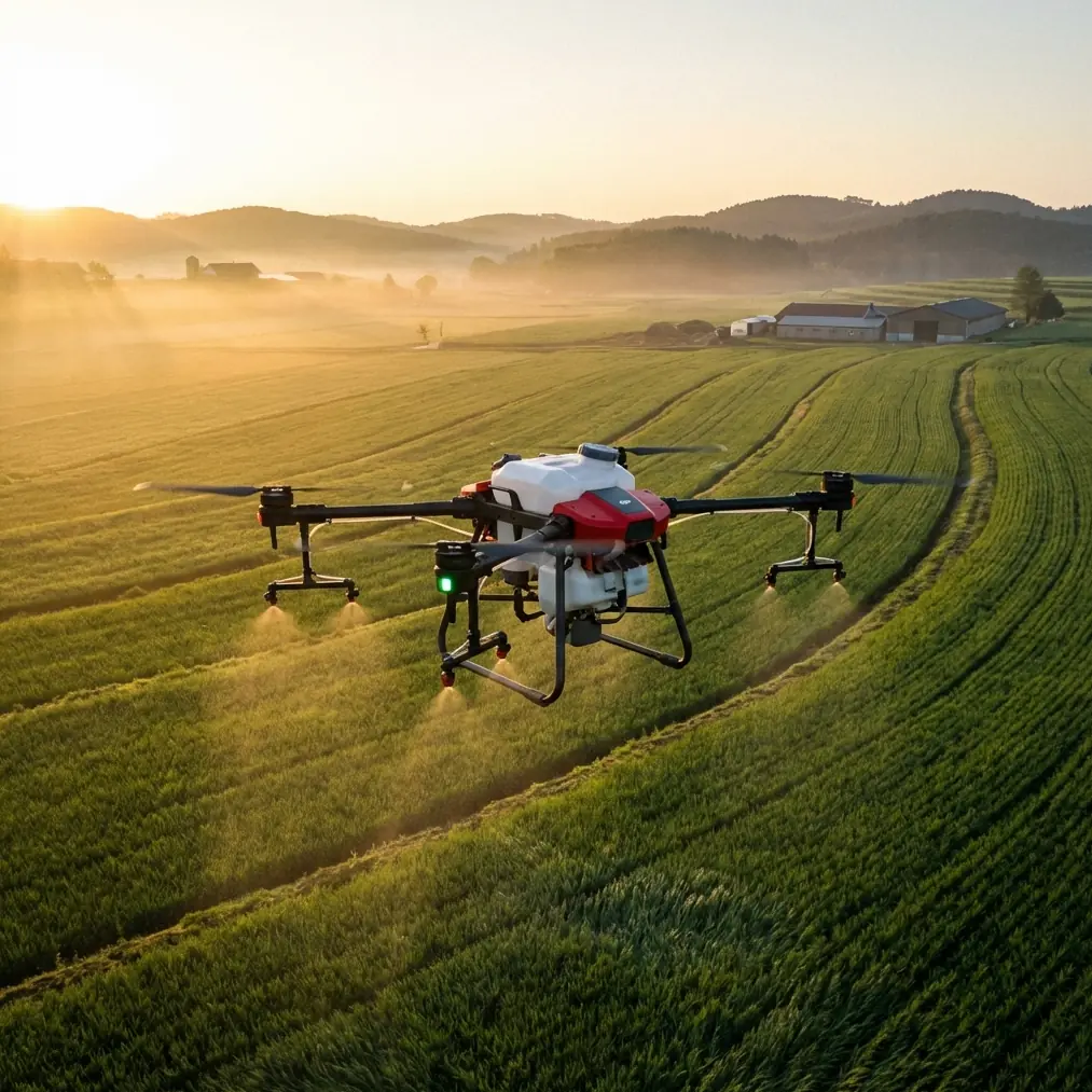
The Agras T70P is most useful in this context when you treat it as a precision field platform rather than a generic drone. The core advantage is not raw airborne presence. It is the ability to execute repeatable low-altitude work over complex vegetation while maintaining a consistent relationship to rows, edges, and irregular canopy structure.
That consistency matters for urban forest blocks where swath width has to be managed carefully. Too wide, and you risk collecting less useful data over roads, rooftops, or off-target vegetation. Too narrow, and productivity collapses, especially when survey windows are limited by pedestrian traffic, school schedules, or local restrictions.
Swath width is not just an efficiency variable. It is a data hygiene variable.
If you are using the T70P in a multi-pass assessment workflow, you want each corridor flown in a way that supports comparison across dates. That is where a strong RTK fix rate and centimeter precision help more than many operators initially realize. Accurate overlap allows health analysis, edge-of-canopy review, and tree-by-tree follow-up with fewer ambiguities.
A practical solution: build the survey around sensor discipline
For urban forest work, the smartest T70P deployments are not built around the aircraft alone. They are built around calibrated sensing.
This is where a third-party multispectral payload integration can materially improve the platform’s value. A well-chosen external multispectral accessory gives the operator something more useful than attractive imagery: it enables vegetation differentiation at a level that supports maintenance decisions. Early stress signatures, moisture anomalies, and uneven vigor zones become easier to isolate before visible crown decline becomes obvious from the street.
That accessory changes the mission from “fly and look” to “measure and compare.”
For an academic or evidence-driven operator, that distinction is crucial. As Dr. Sarah Chen might frame it, urban forestry is not only about documenting what trees look like today. It is about building a repeatable record of condition under changing environmental stress. Heat island effects, restricted root zones, pollution exposure, and runoff patterns can all express themselves unevenly across a single district. Multispectral analysis, paired with reliable positional control, gives those patterns structure.
But what about spray-related terms in a survey mission?
The context around the T70P often includes spray drift and nozzle calibration, and those may seem out of place in a forestry survey article. They are not irrelevant.
Many urban forestry teams do more than inspect. They also plan targeted treatment, health management, or limited intervention work. In that setting, survey intelligence and application accuracy should not be separated. If your survey aircraft platform is also part of a treatment workflow, then nozzle calibration and drift control directly affect whether the mapping insights can be turned into precise action later.
Operationally, here is why that matters:
- Spray drift is a major concern in urban zones because off-target movement can affect sidewalks, parked vehicles, ornamental landscapes, or nearby properties.
- Nozzle calibration determines whether any treatment follows the intended deposition profile rather than an assumed one.
Even if the immediate mission is a survey, a T70P operator who understands drift behavior and nozzle setup is in a stronger position to design more useful survey layers. For example, identifying canopy edges, wind-exposed corners, and constrained corridors in advance can help shape later treatment plans with less risk.
The survey becomes a planning instrument, not just a documentation pass.
Weather and exposure are harsher in cities than many teams expect
Urban operations introduce strange environmental behavior. Wind tunnels form between buildings. Moisture lingers differently in shaded corridors. Dust and grit can be kicked up from hard surfaces. Light rain may not stop municipal schedules, which means operators often face pressure to work in imperfect conditions.
This is where an IPX6K-rated airframe characteristic deserves attention. In practical terms, that level of ingress protection supports field resilience when the aircraft is exposed to splashing water, residue, and harsher cleanup demands than a cleaner rural launch site might present. It does not eliminate weather judgment, of course. But in day-to-day commercial use, durability reduces downtime and preserves consistency across repeated urban deployments.
That matters more than it sounds on paper.
A city forestry contract is rarely won or kept on flight performance alone. Reliability, cleanup speed, turnaround time, and the ability to maintain equipment properly after messy missions all contribute to whether the platform remains economically and operationally viable.
The real workflow: from mission approval to repeat survey
A serious urban forest survey using the Agras T70P should look something like this:
1. Define the sensitivity map before the flight map
Do not begin with tree polygons. Begin with the surrounding context. Identify schools, event venues, substations, arterial roads, rail lines, and any critical infrastructure nearby. The DRONELIFE reporting on new U.S. counter-UAS protocols around high-profile events is a reminder that your mission may be judged partly by where it happens, not just what it does.
2. Lock in positional integrity
Prioritize RTK stability. In urban work, weak fix behavior undermines repeatability. If the objective is trend analysis across weeks or seasons, positional inconsistency can create false canopy changes that are really just mapping drift.
3. Match swath width to the canopy geometry
A wider pass is not automatically better. Narrow, controlled coverage often produces cleaner edge definition in boulevard plantings, pocket parks, and utility-adjacent tree lines.
4. Use multispectral where decisions depend on subtle stress
A third-party multispectral add-on is especially valuable when visual imagery alone cannot distinguish between species variation and genuine stress response.
5. Keep treatment implications in mind
If the same platform will support intervention planning later, survey data should account for likely drift-sensitive zones and canopy structures that will complicate nozzle calibration.
6. Prepare communication for public-facing sites
Urban crews should have a concise explanation ready for facility managers, residents, or inspectors. If your team needs a direct line for pre-mission coordination, one practical option is this project WhatsApp contact.
What separates strong operators from casual flyers
The difference is usually not stick skill. It is systems thinking.
A casual operator sees the T70P as a drone that can cover trees. A strong operator sees a platform that must produce defensible, repeatable outputs in an environment shaped by regulatory caution, public visibility, and physical complexity.
That distinction is becoming sharper. Again, look back at the 2026 DRONELIFE coverage. The article did not describe a settled landscape. It described a U.S. environment still facing multiple challenges in counter-UAS buildup while simultaneously moving toward new protective protocols for major events and critical sites. For civilian professionals, that signals a future in which legitimacy will be demonstrated through discipline.
Urban forestry teams that adapt now will be ahead of that curve.
So, is the Agras T70P a fit for urban forest surveying?
Yes, with a condition: it must be deployed as part of a precision workflow.
The T70P makes sense when the mission requires stable repeatability, controlled corridor coverage, durable field performance, and a path toward data-rich vegetation analysis. It makes even more sense when paired with a third-party multispectral accessory and an operator who understands how survey outputs can inform later treatment decisions involving spray drift and nozzle calibration.
What it is not is a shortcut.
In urban forest work, the aircraft is only one layer. The rest is mission design, airspace judgment, positional confidence, and site communication. Get those right, and the T70P can serve as a serious instrument for municipal arboriculture, campus tree management, utility-adjacent vegetation review, and research-driven canopy health assessment.
Get them wrong, and even a capable platform becomes just another drone attracting attention in the wrong place.
That is the real lesson from today’s environment. Technical capability still matters. But in a city, disciplined operation matters just as much.
Ready for your own Agras T70P? Contact our team for expert consultation.