Agras T70P in Coastal Field Surveying: A Consultant’s Case
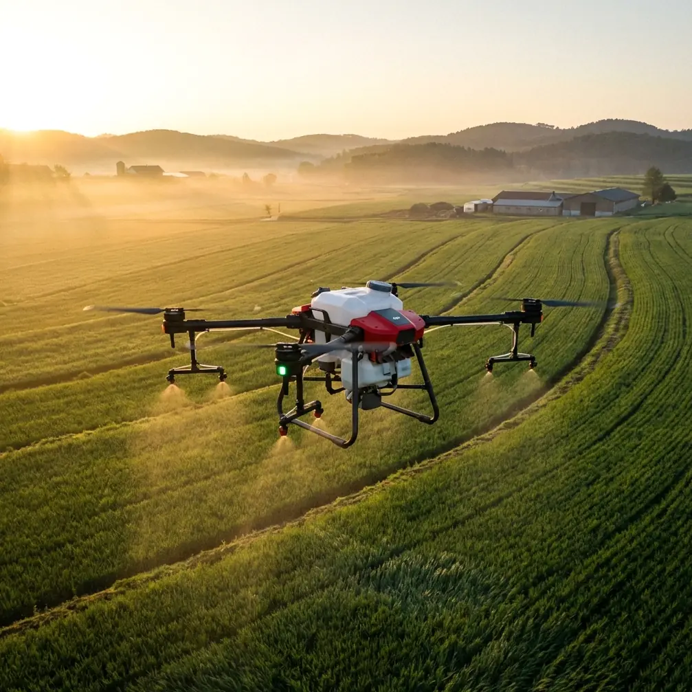
Agras T70P in Coastal Field Surveying: A Consultant’s Case Study on Precision, Salt, and Pre-Flight Discipline
META: A field-focused case study on using the Agras T70P for coastal agricultural surveying, covering RTK fix rate, nozzle calibration, spray drift, multispectral workflow, swath width planning, and a critical pre-flight cleaning step.
Coastal farming has a way of exposing weaknesses fast.
Equipment that behaves perfectly inland can start showing small inconsistencies near the sea: residue buildup, unstable GNSS behavior around moisture-heavy air, corrosion risk after repeated exposure, and spray patterns that drift just enough to turn a clean application plan into a costly compromise. When growers ask me whether the Agras T70P is suitable for surveying and precision field work in coastal conditions, my answer is usually yes—but only if the operation is built around discipline rather than brochure assumptions.
I’ll frame this as a case study, because that is how these decisions actually get made in the field.
I was asked to advise on a coastal farm block where the operator wanted to use the Agras T70P not just as a spray platform, but as a more informed decision tool before treatment. The site had three problems layered together. First, wind behavior changed quickly as sea air moved across open rows. Second, saline residue was accumulating on exposed surfaces. Third, the operator wanted better path confidence and tighter application consistency around irregular field edges and drainage corridors.
The machine itself was only part of the story. The larger question was how to make its precision systems meaningful under coastal stress.
Why the T70P conversation is really about workflow, not just hardware
The Agras T70P attracts attention because it sits at the intersection of capacity, precision, and practical farm throughput. But in coastal surveying and treatment planning, the real value comes from how well it holds a stable operational rhythm: clean sensing, dependable positioning, predictable swath width, and spray output that matches what the operator thinks the aircraft is doing.
That sounds obvious. It rarely is.
A drone can be technically capable and still produce weak agronomic results if the pre-flight routine is sloppy. On coastal sites, this usually starts with contamination. Salt film and fine residue do not need to be dramatic to become a problem. A thin layer on external sensors, nozzle interfaces, frame joints, or protective housings can affect confidence in the system. That is why one of the first things I insist on for T70P crews working near the coast is a dedicated pre-flight cleaning step, not as housekeeping, but as a safety and accuracy measure.
This is where the platform’s weather-sealed build matters. An IPX6K-rated protection level is not a decorative spec. In practical terms, it supports washdown and cleaning routines that are essential for aircraft working in harsh agricultural conditions. Near the sea, that matters even more. A protected airframe gives the crew a realistic chance to remove residue before it turns into sensor interference, nozzle inconsistency, or premature wear.
The pre-flight cleaning step I tell crews not to skip
Before every sortie in a coastal environment, I recommend a short but deliberate cleaning protocol:
- rinse and wipe down exposed surfaces where salt mist can collect
- inspect spray nozzles for partial obstruction or uneven residue
- clean positioning and vision-related surfaces carefully
- check landing gear, folding mechanisms, and cable interfaces for buildup
- confirm no dried formulation is left from the previous mission
That routine usually takes only a few minutes. The operational return is outsized.
Why? Because a drone used for agricultural surveying and precision application depends on trustworthy inputs. If a nozzle is half-restricted, your calibration data is already wrong. If an external sensing surface is dirty, the aircraft may still fly, but your confidence margin shrinks. In coastal work, “almost clean” is often not clean enough.
The T70P is at its best when the operator treats cleaning as part of flight preparation, not an afterthought once the day is over.
RTK fix rate is not a technical vanity metric
The second issue in this case study was positioning reliability. Many operators talk about centimeter precision as if it is a static feature you buy once. In reality, it is a performance state you maintain. For coastal field surveying, RTK fix rate becomes one of the most meaningful indicators of whether the system is ready to deliver repeatable results.
A strong RTK fix rate supports clean route tracking, especially when flying field boundaries, working around irrigation infrastructure, or revisiting the same treatment zones across multiple passes. If the fix quality fluctuates, the consequences can ripple through everything else: edge fidelity, overlap, missed strips, and uncertainty in application records.
That matters even before spraying begins. Surveying is not just about producing a map. It is about creating a route plan the aircraft can execute with confidence. On irregular coastal plots, where field edges may blend into embankments, drainage ditches, or narrow access roads, centimeter precision has direct operational significance. It can reduce waste, tighten line spacing, and improve consistency when the same field is serviced over time.
For this operator, we adjusted the mission timing to avoid periods when atmospheric and local interference conditions were reducing fix stability. That alone improved route confidence noticeably. The lesson was simple: the T70P’s precision systems are valuable, but only when the crew actively monitors fix quality instead of assuming the label “RTK” solves every positioning issue.
Swath width planning near the coast needs restraint
A common error in open farmland is chasing maximum swath width because it looks efficient on paper. Near the coast, that can backfire.
Wind behavior at a shoreline or estuary margin does not always present as a strong constant force. More often, it arrives as uneven lateral movement and low-altitude turbulence. That is where spray drift starts undermining the mission. A wide swath may seem productive, but if droplet behavior becomes inconsistent at the edges, the effective result is poorer than a slightly narrower pass flown with better control.
With the T70P, I generally advise coastal crews to validate actual swath behavior instead of relying on nominal assumptions. This is where nozzle calibration becomes inseparable from route planning. You cannot decide on swath width intelligently if nozzle output, droplet profile, and local wind response have not been checked that day.
In this case, we reduced the field plan to a more conservative working width on the exposed side of the property and kept a broader pattern in the more sheltered interior sections. That split approach improved coverage quality and reduced the operator’s concern about drift toward adjacent non-target zones.
This is one of the reasons I prefer to discuss the T70P as a decision platform rather than a raw throughput machine. The aircraft’s value shows up when the crew uses its precision capabilities to adapt by zone, not when they force the whole property into one uniform setting.
Nozzle calibration is where precision becomes real
If there is one topic I wish more operators treated seriously, it is nozzle calibration.
In agriculture, people often talk about precision in terms of navigation. But fluid delivery is where precision becomes visible to the crop. Even with accurate route execution, poor calibration can produce uneven application, overcompensation on certain passes, and false confidence in the treatment record.
Coastal sites make this harder because residue and humidity can alter behavior over time. Tiny restrictions, uneven wear, or remnants of previous formulations can change output characteristics enough to matter. That is why I treat nozzle checks as a mandatory checkpoint before using the T70P in any serious field survey-to-application workflow.
The operator in this case had assumed the nozzles were fine because total output volume looked normal. On inspection, one side showed early-stage buildup that was not yet severe enough to trigger obvious operational alarm. But the distribution pattern was not as clean as it should have been. After cleaning and recalibration, the aircraft’s pass confidence improved, and more importantly, the agronomic logic of the mission improved. The drone was no longer just flying accurately; it was applying accurately.
That distinction matters.
Multispectral thinking without overcomplicating the mission
Not every coastal grower needs a full multispectral workflow. But the concept is still relevant when discussing the T70P in a surveying context.
Many operators make the mistake of separating survey intelligence from application execution. In practice, the strongest results come when those two functions inform each other. If a farm is already using multispectral data from another platform to identify stress zones, standing moisture, or inconsistent vigor, the T70P becomes much more valuable as the execution layer. It can follow precise routes shaped by actual crop variability rather than broad assumptions.
For the coastal farm in this case, we used prior field intelligence to identify sections where overspray risk and plant response sensitivity were both higher. That changed how we staged the mission. We did not treat the whole block as equally tolerant to drift or equally suitable for broad-pass efficiency. The T70P worked better because it was inserted into a smarter information chain.
That is the practical future of these aircraft in agriculture. Not isolated tasks. Connected decisions.
A note on autonomy, and what civilian operators should actually care about
There has been plenty of industry discussion around upgraded autonomy software in the wider drone sector. One example from the news cycle is Teledyne FLIR OEM’s recent Prism SKR software update, announced on April 8, 2026, which combines mission execution and intelligent supervision in a single software platform. That release was framed around defense-related autonomous target recognition, which is outside the scope of commercial farm operations. Still, one aspect is worth noticing from a civilian perspective: the market is clearly moving toward tighter integration between automated execution and higher-level oversight.
Why does that matter for an Agras T70P operator surveying fields near the coast?
Because the useful lesson is not about defense software. It is about how autonomy in professional drones is maturing. Commercial agriculture benefits when mission planning, route execution, and operator supervision are treated as one connected system rather than separate boxes. In farm terms, that means fewer mismatches between what was planned, what the aircraft actually flew, and what the operator believed happened.
For coastal work, where conditions shift quickly, intelligent supervision is not an abstract software concept. It is the difference between adjusting for drift risk in time or discovering the problem after application is already complete.
What changed after the workflow was tightened
Once the crew adopted a proper pre-flight cleaning routine, checked RTK fix stability before launch, recalibrated nozzles, and stopped trying to force a single swath width across the whole property, the T70P settled into a much more reliable role.
The biggest improvement was not headline speed. It was trust.
The operator trusted the path repeatability more. He trusted the application pattern more. He trusted the aircraft to work in a salt-exposed environment because maintenance was now planned instead of reactive. And he had a clearer framework for using survey data to shape treatment decisions rather than merely document them.
That is where the T70P earns its place on coastal farms. Not because it ignores environmental difficulty, but because it can perform well when the crew respects those difficulties and builds the mission around them.
My practical recommendation for coastal operators
If you are evaluating the Agras T70P for surveying fields in coastal conditions, do not start by asking how much ground it can cover in ideal weather. Start with four tighter questions:
- Can your crew maintain a consistent pre-flight cleaning routine after every salt-exposed operation?
- Are you actively monitoring RTK fix rate, or just assuming centimeter precision is always present?
- Have you validated nozzle calibration recently enough to trust your swath assumptions?
- Are you adjusting route width and drift strategy by zone, or treating the entire property as one generic field?
If the answer to those questions is strong, the T70P can be a very effective tool in coastal agriculture. If not, even a capable aircraft will produce uneven outcomes.
I say that as a consultant, not as someone dazzled by feature sheets. Agriculture rewards repeatability, and coastal agriculture punishes shortcuts.
If you want to compare field setup notes or sanity-check a coastal workflow before deployment, you can reach out through this direct WhatsApp line.
The T70P has the ingredients to do serious work in harsh farm environments. But the real edge comes from how it is prepared, cleaned, calibrated, and supervised. On the coast, that is the difference between a drone that merely flies and one that becomes part of a dependable agronomic system.
Ready for your own Agras T70P? Contact our team for expert consultation.