Agras T70P Surveying Tips for Mountain Fields
Agras T70P Surveying Tips for Mountain Fields: What Actually Matters on Steep, Broken Ground
META: Practical Agras T70P guidance for surveying mountain fields, with expert insights on RTK fix rate, spray drift, nozzle calibration, swath width, and reliable operation in wet, uneven terrain.
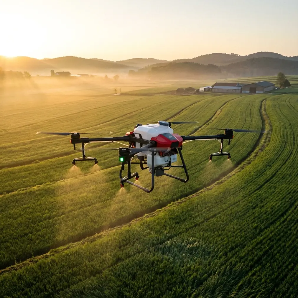
Mountain fields expose every weakness in a UAV workflow. Slopes bend sightlines. Terraces interrupt clean flight paths. Wind behaves differently at the ridgeline than it does in the valley. Moisture hangs around longer, and access on foot is usually the slowest part of the job. If you are evaluating the Agras T70P for work in this environment, the right question is not whether it is powerful enough. The real question is whether its precision, stability, and field practicality hold up when the terrain stops being forgiving.
That distinction matters.
I still remember one hillside block where the field notes looked tidy on paper, but the actual site was a mess of narrow ledges, uneven elevation changes, and abrupt crosswinds that kicked up around mid-morning. The trouble was not simply getting airborne. The trouble was maintaining consistent coverage logic across sections that never behaved like a flat field. On terrain like that, small errors compound fast. A weak RTK lock turns into sloppy edge alignment. Poor nozzle calibration creates uneven application as speed and altitude shift along the slope. A swath width that seems efficient in ideal conditions can become wasteful or risky when the aircraft is working close to terraces, trees, and drainage channels.
That is the context where the Agras T70P becomes interesting.
This is not because mountain operations demand a magical aircraft. They demand an aircraft that reduces the number of variables an operator has to fight at once. The T70P stands out when you look at it through that lens: not as a generic agricultural drone, but as a system that can make complex terrain more manageable when the operator respects the fundamentals.
The mountain-field problem is really a precision problem
People often describe mountain agriculture as an access problem. It is partly that. Reaching the plots, staging batteries, and moving materials all take longer. But from the air, the bigger issue is precision under instability.
On flat ground, the difference between a decent line and an excellent line may not show up immediately. On steep terrain, it does. If your aircraft drifts a little on each pass, or if your positioning data keeps wavering before it settles, those small misses become visible in skipped strips, overlap inconsistencies, and unreliable treatment boundaries. That is why RTK performance deserves more attention than many operators give it.
For mountain surveying and mission planning, the RTK fix rate is not just a spec-sheet talking point. It directly influences how confidently you can map irregular plots, repeat routes, and return to problem sections without rebuilding the job from scratch. If the aircraft can maintain centimeter precision with a strong, stable fix, the operator has a much better chance of keeping passes aligned even when the terrain pushes the machine to constantly adapt. In practice, that means fewer corrective flights, better confidence at field edges, and cleaner records for agronomic follow-up.
Centimeter precision also changes how you think about terraces. On steep land, terraces are not just field features. They are flight constraints. The aircraft needs to handle each contour as part of a sequence, not as a single open block. When the positioning solution is trustworthy, the T70P can be used more deliberately around retaining edges, crop boundaries, and segmented planting zones. That reduces hesitation in the air, which often translates into safer and more efficient work.
Why spray drift gets worse in mountain conditions
Even if your main purpose is surveying and route planning, spray drift should still be part of your evaluation. In mountain operations, survey quality and application quality are linked. The more accurately you understand airflow, elevation changes, and obstacle proximity during the survey phase, the more disciplined the later treatment phase becomes.
This is where many crews get caught out. Wind on a hillside is rarely uniform. A reading taken near the loading area may tell you very little about what happens fifty meters higher up the slope. Air can accelerate around exposed corners, funnel through narrow contours, or suddenly lift near warm, sun-facing sections. That means the spray pattern you expected at takeoff can behave differently over each pass.
The operational implication is straightforward: swath width should not be treated as a fixed efficiency target. It should be adjusted according to terrain exposure, crop density, and lateral wind behavior. A wider swath can look productive, but in mountain fields it often creates a false sense of efficiency. If the aircraft is pushing droplets into adjacent rows, gullies, or non-target vegetation, the mission is not efficient. It is simply covering more uncertainty.
With the Agras T70P, disciplined operators will get more value by narrowing the working logic where terrain demands it, then using accurate route repetition to maintain throughput. That approach sounds conservative, but it usually wins in the real world. Precision protects output. Drift destroys it.
Nozzle calibration is not a setup chore. It is a terrain adaptation step
One of the most overlooked issues in mountain agriculture is how quickly application uniformity can degrade when calibration is treated as a one-time task. It is not enough to assume a previous setting will behave identically on a new slope profile.
Nozzle calibration matters more on steep and broken ground because the aircraft is constantly dealing with altitude variation, speed changes near boundaries, and differing canopy exposure. If the system is not calibrated with those realities in mind, you can end up with visible variation between upper-slope and lower-slope sections. Some areas receive too much. Some too little. Neither outcome is acceptable when margins are tight and terrain already limits access for rework.
The T70P makes more sense in mountain environments when operators treat calibration as part of site-specific planning rather than routine prep. That means checking spray consistency before the mission, reviewing expected operating altitude relative to crop height, and adjusting for the actual field shape rather than the idealized map. If you are surveying first and applying later, your survey should feed that calibration logic. Where are the exposed corners? Where does the terrain force deceleration? Which terraces are too narrow for a broad pass? The drone does not answer those questions by itself. But a platform with strong positional confidence and stable control gives you a better chance of acting on the answers.
Wet weather and washdown realities make durability more than a convenience
Mountain field work often starts with dew and ends with mud. Even when it does not rain, moisture has a way of lingering longer in elevated or shaded blocks. Dust can also be surprisingly aggressive, especially where paths are dry and loose. That combination is hard on agricultural equipment.
This is one reason the T70P’s IPX6K protection matters operationally. For mountain crews, rugged sealing is not just a durability bullet point. It affects how confidently the aircraft can be used through wet vegetation, post-rinse cleanup, and messy field conditions where exposure to water and debris is hard to avoid. An IPX6K-rated platform is better positioned for the reality of frequent cleaning and demanding environmental exposure, which matters when you cannot afford extended downtime just because the day started wet or the launch site was less than ideal.
In mountain operations, reliability is cumulative. A machine that tolerates repeated field washdowns, splashing, and dirty staging zones saves more than maintenance time. It preserves your schedule. If your team loses a flying window because equipment prep becomes fragile or overly cautious in damp conditions, the terrain has already won.
Multispectral thinking belongs in the workflow, even if the aircraft’s role is operational
Mountain fields are rarely uniform enough to justify a one-pattern strategy. Aspect, elevation, water retention, and sunlight exposure can vary dramatically within a relatively small area. That is why multispectral data remains relevant in a discussion centered on the Agras T70P.
Even if the T70P itself is being used as the operational workhorse rather than the primary imaging platform, multispectral insights can dramatically improve how you deploy it. Zones with different plant stress signatures may require different application timing, different route emphasis, or different treatment restraint where drift risk is elevated. In mountain agriculture, variable conditions are not an exception. They are the baseline.
The smart workflow is to let imaging define the prescription logic, then let a precise aircraft execute on that logic with as little positional ambiguity as possible. This is another place where RTK fix rate and centimeter precision stop being abstract features and become practical tools. If you are trying to act on a multispectral finding from a narrow hillside block, your aircraft has to return to that zone with confidence. A vague approximation is not good enough when the target area may be bordered by a footpath, a drainage line, or a neighboring crop on a different terrace.
A better way to think about swath width on steep land
Operators often ask for the “best” swath width for mountain fields, but that is the wrong framing. There is no single best number because the terrain is dictating the answer.
A better question is this: what swath width preserves control while still delivering useful output on this specific slope, in this wind, over this canopy? Once you frame it that way, the T70P’s role becomes clearer. It is there to help you maintain repeatable performance while you adapt the mission to reality.
On open sections of a mountain field, a broader swath may be acceptable. Near terrace edges, retaining walls, orchard margins, or exposed wind channels, a tighter swath is usually the wiser call. That does not mean you are sacrificing productivity. It means you are preventing waste, avoiding off-target deposition, and preserving confidence in the treatment map. Across a full day, that tends to outperform operators who chase maximum width everywhere and spend the afternoon correcting avoidable misses.
What changed for me when using this class of platform
The biggest improvement was not speed. It was composure.
Older mountain workflows often felt like constant compensation. You compensated for uncertain positioning. You compensated for inconsistent edge control. You compensated for the fact that every route adjustment introduced another layer of doubt. By the time the mission ended, you had coverage, but not always confidence.
The T70P changes that equation when it is used properly. Better positional discipline supports cleaner route planning. Stronger environmental resilience supports more consistent field uptime. Thoughtful calibration and swath decisions reduce the tendency to overcorrect in the air. Instead of wrestling the terrain at every turn, you begin working with a repeatable operating structure.
That is what mountain operators need most: not brute force, but fewer unresolved variables.
If you are planning a mountain-field workflow and want a second set of eyes on route logic, calibration, or terrain-specific setup, you can message an agras workflow specialist here.
Practical field advice for T70P operators in mountain surveys
Before each mission, verify your RTK status before treating any mapped line as reliable. On mountain terrain, a delayed or unstable fix is not a minor inconvenience. It can distort the entire mission structure.
Use your survey pass to identify drift corridors, not just obstacles. Trees, cut slopes, open ridges, and breaks in terrace walls often reveal where airflow will behave unpredictably later in the day.
Treat nozzle calibration as field-specific. If the crop block changes elevation sharply or includes narrow terraces, review settings with that shape in mind rather than relying on the last successful job.
Resist the urge to keep swath width wide just to improve headline productivity. In mountain work, clean targeting almost always beats theoretical throughput.
Take the IPX6K protection seriously as a maintenance advantage. Clean equipment properly after wet or muddy work so durability remains a real asset, not an excuse for neglect.
If multispectral data is available, use it to decide where precision matters most. Mountain fields often contain high-variability zones that reward careful route repetition and punish casual approximation.
The bottom line for mountain-field work
The Agras T70P makes the most sense in mountain agriculture when you stop viewing it as a general-purpose field drone and start treating it as a precision tool for unstable environments. Its value shows up in the details: how well you hold an RTK fix, how confidently you work at centimeter precision around terraces, how carefully you calibrate nozzles, how realistically you manage swath width, and how much reliability you preserve in wet, dirty conditions with IPX6K-level protection.
Those details are not secondary. They are the job.
On flat land, a mediocre process can still limp to an acceptable result. On mountain fields, it usually cannot. That is why the T70P deserves attention from operators dealing with slopes, fragmented plots, and difficult access. Used carelessly, it is just another aircraft. Used with terrain discipline, it becomes a much more effective answer to one of agriculture’s hardest operating environments.
Ready for your own Agras T70P? Contact our team for expert consultation.