Agras T70P for Urban Coastline Surveying
Agras T70P for Urban Coastline Surveying: A Technical Review from an Agricultural Platform Perspective
META: A technical review of the Agras T70P for urban coastline surveying, covering RTK precision, swath control, spray-system implications, environmental durability, and practical field workflow considerations.
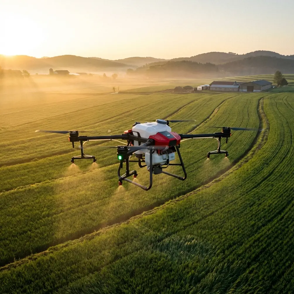
The Agras T70P sits in an unusual position. It is not marketed first as a shoreline mapping aircraft, and that is exactly why it deserves a closer look. Most readers arrive at the T70P through agriculture: payload, spraying efficiency, nozzle behavior, and field productivity. But when the operating environment shifts from orchards and row crops to dense urban coastlines, some of the same engineering choices start to matter in a different way.
That crossover is worth examining carefully.
Urban coastline surveying is demanding for any UAV. Salt exposure stresses hardware. Wind patterns change abruptly around seawalls, towers, bridges, and port infrastructure. GNSS conditions can degrade near vertical surfaces. Launch and recovery space may be tight. A platform that looks strong on a farm can become awkward or overbuilt on the waterfront. At the same time, a drone designed for high-throughput agricultural work may bring advantages that lighter survey aircraft simply do not match: robust weather resistance, stable low-altitude performance, and strong route discipline over long linear corridors.
From that perspective, the Agras T70P becomes a more interesting machine than its category label suggests.
Why the T70P deserves attention outside pure spraying work
The first thing to understand is that the T70P’s agricultural DNA is not a limitation by default. In some urban coastline operations, it can be an asset. Shoreline survey tasks often involve repetitive, corridor-style flight paths along embankments, drainage channels, reclaimed land edges, marine construction zones, and vegetated tidal margins. These are not always classic “mapping blocks.” They are long, irregular strips that benefit from predictable track spacing and highly repeatable navigation.
That is where centimeter precision and RTK behavior matter.
A strong RTK fix rate is not just a specification line. Along a coastline, especially in urban sections, you may be flying adjacent to reflective water, metal railings, container yards, glass facades, or concrete walls. The drone’s ability to maintain an RTK solution consistently affects route fidelity, overlap quality, and how confidently you can revisit the same line later for condition monitoring. If the T70P holds its line well under these mixed GNSS conditions, the practical outcome is straightforward: fewer lateral deviations, more reliable corridor reconstruction, and cleaner change detection over time.
Competitors in the broader survey UAV category often emphasize camera sophistication first. The T70P’s edge, by contrast, is platform discipline. That distinction matters. A coastline survey is only as good as the repeatability of the aircraft carrying the sensor package or observational payload. If flight-path consistency degrades near the waterline or around urban structures, downstream data quality suffers long before anyone opens processing software.
RTK and coastline work: precision is only useful if it survives the environment
The phrase “centimeter precision” gets used casually in drone marketing. On a waterfront project, it should be treated more seriously. Precision in open inland fields is one thing. Precision along an urban coast is another.
A workable RTK fix rate in this setting has operational significance in at least three ways:
Boundary consistency
Coastal assets are often managed by narrow tolerances: erosion edges, retaining wall alignment, vegetation encroachment, drainage outfalls, and construction-setback limits. If repeated flights drift slightly from planned tracks, the data may still look acceptable visually while becoming weaker for comparison over weeks or months.Safer corridor adherence
In urban areas, there may be roads, pedestrian spaces, moored vessels, fenced facilities, and restricted structures close to the route. Better positional certainty helps the aircraft remain where it is meant to be, which reduces operational friction and simplifies mission planning.Improved overlap on irregular shorelines
Coastlines are rarely straight. They include curves, inlets, harbor edges, and engineered revetments. RTK stability supports more predictable swath placement as the route bends and narrows.
Survey drones designed specifically for mapping may still outperform the T70P in sensor integration flexibility. But for line-holding and low-altitude route stability in rough air, the T70P can compare favorably because it was built for demanding outdoor work rather than pristine laboratory conditions.
Swath width is not just an agricultural metric
One of the more overlooked concepts when adapting an agricultural UAV to survey-related operations is swath width. In spraying, swath width determines treatment efficiency and coverage uniformity. In coastline surveying, the same idea translates into how much shoreline face, embankment shoulder, vegetation margin, or drainage strip can be captured per pass.
Even when the payload or mission is not a traditional spray run, the T70P’s operational logic is built around broad, organized coverage. That changes workflow. A team inspecting several kilometers of urban shoreline is not just trying to “fly and capture.” They are trying to maintain consistent lateral spacing over a complex edge environment. A platform designed to think in terms of wide, repeatable bands can be valuable here.
This is especially useful where the shoreline includes a mix of hardscape and vegetation. Surveyors may need to examine:
- riprap displacement,
- grass or reed encroachment,
- standing water near outfalls,
- changes in sediment edge,
- access-path condition,
- stormwater structure visibility.
A predictable pass structure saves time in the field and reduces the need for corrective re-flights. That is not glamorous, but it is what separates a smooth morning operation from an afternoon lost to patchwork coverage.
Spray drift and nozzle calibration still matter, even in a surveying conversation
At first glance, spray drift and nozzle calibration seem irrelevant if the reader’s scenario is coastline surveying. They are not irrelevant. They reveal something about the aircraft’s control philosophy.
An agricultural platform that manages droplet behavior effectively must control altitude, speed, and route stability with discipline. Drift is shaped by airflow, wind, droplet size, boom geometry, and aircraft motion. Nozzle calibration depends on repeatable system behavior. Those same factors, when viewed through a surveying lens, tell you whether the aircraft is likely to behave predictably in a coastal wind field.
This is one area where the T70P can excel against lighter or less rugged competitors. A platform built to support precise application work is forced to deal with real-world aerodynamic disturbance. That operational maturity often translates well to low-level coastal runs where crosswinds and gust shear can upset smaller airframes.
There is another practical angle. Urban coastlines are environmentally sensitive. If the mission includes vegetation management, restoration support, or selective treatment in adjacent green zones, spray drift becomes a public-facing issue, not just a technical one. The T70P’s suitability depends on careful nozzle calibration and conservative operational planning so material stays where it belongs. Along a shoreline near roads, promenades, or drainage channels, this is non-negotiable.
So even when the core task is surveying, the aircraft’s spray-system pedigree provides useful evidence about how seriously it treats control accuracy under variable wind conditions.
IPX6K-level protection is not a luxury near saltwater
Coastal work punishes drones. Fine salt spray reaches everywhere. Hardware gets damp during setup, transit, and recovery. The aircraft may not be submerged, but it does not need to be. Repeated exposure to saline moisture and airborne particulates can shorten service life quickly.
This is why IPX6K-class environmental protection deserves more attention than it usually gets. In practical terms, a system rated to withstand powerful water exposure is better aligned with shoreline operations than lightly protected airframes that perform well only in ideal weather windows. No ingress rating eliminates the need for maintenance, but higher protection changes the margin for error.
For urban coastline teams, the operational significance is clear:
- less anxiety when working in sea mist or intermittent spray,
- more confidence during wash-down and decontamination routines,
- better durability in damp staging areas,
- a more realistic fit for repeated deployment in marine-adjacent environments.
Competitors may offer sleek survey platforms with strong imaging stacks, but not all are equally comfortable around salt, wind, and dirty field conditions. The T70P’s durability-oriented design gives it an advantage when the work site itself is harsh.
What about multispectral use?
Multispectral capability matters if the mission extends beyond geometry into environmental interpretation. Along coastlines, that can include vegetation health, drainage signatures, wetland transitions, stressed turf near flood defenses, or restoration monitoring. Whether the T70P is the ideal dedicated multispectral survey aircraft depends on payload ecosystem and mission setup, but the concept is relevant.
Where this becomes valuable is in mixed shoreline assessments. Urban coasts are rarely only “infrastructure” or only “ecology.” They are both. A seawall may sit beside managed grass, invasive vegetation, mudflat edge, drainage discharge, and landscaped public space. A platform that can support repeatable corridor operations while contributing to multispectral observation creates efficiency in projects where engineering and environmental teams need to look at the same ground.
That said, decision-makers should be honest: if the project is a pure photogrammetric or specialist multispectral campaign, there may be more purpose-built mapping drones available. The T70P is most compelling when the job blends rugged field operations, repeatability, and environmental exposure tolerance.
Field workflow for urban shoreline missions
The T70P makes the most sense when the survey plan respects what the aircraft is built to do well.
A practical workflow would prioritize:
- RTK base or network verification before launch to ensure the fix is stable near waterfront structures.
- Conservative altitude selection around bridges, poles, signs, and embankment changes.
- Corridor-based route design rather than forcing a standard block mapping template onto an irregular coast.
- Wind-aware pass direction to reduce cross-track deviation over water-adjacent sections.
- Post-flight cleaning with special attention to salt residue around landing gear, joints, and exposed surfaces.
In shoreline environments, operational neatness matters as much as flight capability. Teams that treat the T70P like a tough field instrument rather than a generic camera carrier tend to get better results.
If you are comparing deployment strategies or need a second opinion on whether this platform fits a marine-edge workflow, this direct project discussion channel is a practical way to review mission details.
Where the T70P stands against competing survey platforms
The simplest comparison is this: many dedicated survey drones are optimized for sensor-centric data capture in controlled workflows. The Agras T70P is optimized for outdoor productivity under imperfect conditions. For urban coastline work, that difference can tilt the decision.
Where the T70P tends to stand out:
- robust environmental tolerance, including IPX6K-level protection,
- stable corridor operation where RTK fix consistency matters,
- strong suitability for repetitive low-altitude coverage tasks,
- a design philosophy shaped by wind, drift, and real-world field variables.
Where specialized competitors may still lead:
- turnkey photogrammetry ecosystems,
- lighter logistics footprint,
- more native options for mapping-specific sensors,
- workflows tailored purely to survey deliverables rather than agricultural crossover use.
That does not weaken the T70P’s case. It sharpens it. The T70P is not the universal answer for every coastline survey. It is the stronger answer when the site is difficult, the air is messy, the route is repetitive, and the hardware needs to tolerate marine-adjacent abuse without becoming fragile.
Final assessment
The Agras T70P becomes genuinely compelling when you stop asking whether it is a “survey drone” in the narrowest sense and start asking whether it is a capable platform for shoreline data work in real urban conditions.
Its likely strengths are not decorative. RTK-supported centimeter precision has direct value for repeat shoreline monitoring. Swath-oriented flight logic supports efficient corridor coverage. Spray drift behavior and nozzle calibration heritage point to a control system designed for disciplined low-altitude performance. IPX6K protection is highly relevant near saltwater. And if environmental analysis enters the picture, multispectral-adjacent workflows become part of a broader, more useful mission profile.
That combination is unusual.
For teams working along urban coasts, especially where infrastructure and environmental observation overlap, the T70P deserves evaluation on its operational resilience, not just its category label. In that comparison, it often looks stronger than expected.
Ready for your own Agras T70P? Contact our team for expert consultation.