Agras T70P for High-Altitude Power Line Scouting
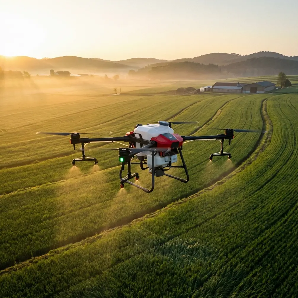
Agras T70P for High-Altitude Power Line Scouting: What Actually Matters in the Field
META: A technical review of using the Agras T70P for high-altitude power line scouting, with field-relevant insights on battery logistics, wind limits, RTK precision, weather discipline, and sensor workflow.
The Agras T70P is usually discussed through the lens of crop protection. That is too narrow. For operators working around mountain corridors, utility access tracks, and long inspection days above farmland, the more interesting question is whether a platform designed for demanding agricultural duty can translate into reliable high-altitude power line scouting.
My view: it can, but only if you evaluate it like an operations tool, not a brochure item.
That distinction matters because power line scouting in elevated terrain exposes the weak points of any UAV workflow. Thin margins on battery planning. Changing wind. Limited places to charge. Long reposition cycles between towers. Wet dust, light rain, and contamination from roadside mud. Even before you talk about image quality or centimeter precision, you are dealing with field discipline.
The T70P enters this discussion with one clear advantage: agricultural UAVs are built around repetition, contamination resistance, and high daily workload. Those traits are directly useful for utility scouting, especially when the route crosses semi-rural infrastructure where support conditions are inconsistent.
Why an agricultural platform belongs in a utility scouting conversation
If you have spent time with transmission or distribution inspection crews, you know the aircraft is only one part of the job. The real challenge is sustaining a full day of consistent sorties across uneven terrain. That is where lessons from plant protection operations become surprisingly relevant.
One practical reference from agricultural flight service teams is battery provisioning. Electric multirotor teams commonly prepare 5 to 10 battery sets, along with chargers, and may carry a generator when charging at the work site is inconvenient. That number is not trivia. It reflects the rhythm of real field work: flights do not fail because the aircraft cannot fly, but because the operator underestimates turnaround logistics.
For high-altitude power line scouting with the Agras T70P, this is the first battery management tip I give clients: do not build your day around nominal flight time. Build it around energy recovery and route friction.
In mountain utility corridors, vehicles may be forced to park far from the best launch point. Tower access roads may be rough or blocked. You may spend more time repositioning than expected. A practical battery rotation plan for the T70P should assume at least one battery set is always cooling, one is charging, one is queued, and one is flying. If the site is remote, generator-backed charging stops being optional. It becomes operational insurance.
That one habit often does more for mission continuity than arguing over a few extra minutes of theoretical endurance.
Wind discipline is not a footnote
Utility inspection teams sometimes become overconfident because line routes are familiar. Familiarity does not weaken the wind.
A useful field benchmark from crop-spraying operations is that wind above level 3 can cause major drift problems during pesticide work. Now, power line scouting is not a spraying mission, but the operational lesson still holds: once surface and slope winds start shifting beyond a modest threshold, the aircraft’s ability to hold a precise and repeatable inspection path degrades, especially near towers, crossarms, and terrain breaks.
This is where the T70P’s flight control quality and RTK fix rate matter more than raw speed. In a utility context, centimeter precision is not just a mapping phrase. It affects whether repeat passes along the same conductor corridor are smooth, whether image overlap is dependable, and whether the pilot can maintain stable standoff from structures without constant manual correction.
When readers ask whether the Agras T70P is suitable for scouting power lines in high altitude, I usually answer with a condition: yes, if you respect weather limits before the mission starts, not after stability begins to degrade.
Agricultural service teams already use a strict go/no-go logic. They avoid launch when recent rain is present or when stronger wind is expected. That kind of discipline should carry directly into power infrastructure work. In exposed ridgelines, “still manageable” conditions on the ground can become highly unstable near line height.
RTK, repeatability, and the real value of precision
The T70P discussion often drifts toward payload heritage and spraying capability. For utility scouting, those details are secondary. The core issue is repeatability.
Power line inspections are rarely one-off flights. You may need to revisit the same corridor after a storm, compare vegetation encroachment over time, or document hardware condition from nearly identical viewing angles. An aircraft with solid RTK performance gives you more than better positioning on a spec sheet. It gives you consistency in mission geometry.
That consistency influences:
- corridor tracking near slope transitions
- image registration across repeat visits
- safer route planning around towers and guyed structures
- cleaner documentation when teams compare findings over multiple inspection dates
The phrase “RTK fix rate” sounds technical, but operationally it boils down to trust. Can the pilot trust the aircraft to hold the intended path when the terrain gets awkward? Can the data team trust the location record enough to compare defects or vegetation boundaries later?
For power line scouting, that answer matters every single day.
A note on environmental sealing and contamination resistance
High-altitude utility routes are often dirty in a very specific way. Fine dust from gravel roads. Moisture from low cloud. Mud spray from support vehicles. Plant debris at improvised launch points. Light contamination from utility easements after rainfall.
That is why ruggedization should not be treated as cosmetic. A platform associated with agricultural work usually earns attention because it can tolerate more abuse than a lightly built camera drone. If your T70P configuration includes IPX6K-level protection, that has practical significance in utility operations. It means the aircraft is better aligned with the kind of repeated cleaning and environmental exposure that long corridor scouting creates.
The point is not that sealing makes bad weather irrelevant. It does not. The point is that a properly protected aircraft is easier to maintain in dirty field cycles, and maintenance discipline is what preserves reliability over a full inspection season.
Agricultural crews understand this instinctively. End-of-day cleaning and system checks are part of the workflow, not an afterthought. One source document describes the routine clearly: after operations, teams clean the aircraft, inspect the UAV system, check consumption of batteries and other materials, and record daily sortie counts and area covered. Translate that to power line scouting and the equivalent is obvious: clean the airframe, inspect the propulsion system, confirm sensor mounts, log flight cycles, and reconcile the energy used against the route completed.
That is how small issues get caught before they become canceled missions.
What spray-field logic teaches us about line inspection planning
At first glance, spray drift and nozzle calibration seem unrelated to utility scouting. They are not.
Here is the connection: agricultural drones reward operators who think in terms of controlled coverage. Swath width, droplet placement, nozzle behavior, and drift are all expressions of one underlying discipline—repeatable movement through a variable environment.
When you move the T70P into line scouting, that same mindset becomes corridor discipline. Instead of monitoring spray drift, you are managing image drift and path drift. Instead of nozzle calibration, you are validating the geometry of your sensor setup and confirming that the aircraft is producing the coverage density you expect. Instead of spray swath width, you are thinking about viewing envelope and standoff corridor.
This is also where the conversation around multispectral or advanced sensing becomes more interesting than many realize. A reference on UAV hyperspectral imaging notes that traditional remote sensing for water-quality inversion has often relied on standard satellite data such as Landsat, SPOT, and MODIS-type sources, but their spectral resolution can be insufficient for certain tasks. It also points out that hyperspectral methods can improve inversion accuracy, while analytic approaches often require substantial synchronized meteorological and optical data that are difficult to obtain.
Why bring that into a T70P article about power lines?
Because it shows the larger truth about UAV sensing: better field decisions come from matching the sensor workflow to the operational question, not simply using more complex data. For utility corridor scouting, a multispectral payload can be valuable when vegetation encroachment, moisture stress, or environmental change near easements matters. But if the data chain requires impossible synchronization or cumbersome calibration in mountain conditions, the theoretical sensor advantage may not survive contact with field reality.
That lesson is highly relevant to the T70P. A drone is only as useful as the data you can repeatedly collect, interpret, and act on.
High-altitude scouting is a logistics problem disguised as a flight problem
This is the part many reviews skip.
In remote or elevated utility sites, access often determines mission quality more than aircraft speed. If you have to run power from vehicles, stage batteries under shade, and keep turnaround times predictable, the T70P’s suitability depends on whether your team can support its operational tempo.
Agricultural flight teams have already solved versions of this problem. They bring not just batteries and chargers, but radios, protective gear, transport containers, and a clear sequence of preflight checks. They also plan around temperature. One practical threshold from field spraying work is that when ambient temperature rises above 35 degrees Celsius, application should stop because performance and effect degrade. For utility scouting, the exact stopping point may vary with mission type, but the principle remains: thermal load changes aircraft behavior, battery performance, and pilot workload. In hot exposed valleys below mountain lines, this can be a bigger factor than many expect.
My recommendation is simple. If you deploy the Agras T70P for line scouting, treat each day like a structured field campaign:
- confirm launch and recovery points before the first battery is inserted
- verify RTK conditions and expected terrain shadowing
- assign battery rotation and cooling order
- inspect wind on the ridgeline, not just at vehicle level
- define image or sensor objectives before takeoff
- log every sortie with enough detail to resume the route the next day without guesswork
That last point comes straight from agricultural operations, where teams record the stopping point at day’s end so work can continue precisely the following day. Utility scouting benefits from the same habit. In long corridors, “we’ll remember where we stopped” is not a system.
The eVTOL headline is interesting, but not the immediate story here
There is also a broader industry signal in the background. A recent report noted that Volant Aerotech secured 300 million US dollars in financing, with funds aimed at airworthiness certification and accelerating scaled commercial delivery of its VE25-100 aircraft. That matters because it shows capital is still moving into low-altitude aviation infrastructure and commercial aircraft development.
But for T70P operators today, the significance is indirect. The future may include more layered aerial ecosystems—inspection drones, cargo drones, and certified passenger or utility-support aircraft sharing the same broader low-altitude economy. Yet the daily work of corridor scouting is still won by practical reliability: power management, environmental tolerance, route repeatability, and useful data capture.
Big financing rounds shape the horizon. Field procedures shape the result.
Should you use the Agras T70P for high-altitude power line scouting?
If your operation values rugged field workflow, disciplined battery rotation, and repeatable path control, the answer is yes—with the right mission architecture.
The Agras T70P makes the most sense when:
- the route crosses agricultural or semi-rural terrain where ruggedness matters
- battery and charging logistics can be actively managed
- the team understands that wind and terrain are mission-limiters, not minor variables
- RTK-backed consistency is needed for repeat visits
- sensor selection is tied to a clear inspection objective rather than novelty
What it is not is a magic substitute for planning. In fact, this airframe rewards planning more than lightweight consumer systems do.
If you are comparing inspection workflows, I suggest starting with one honest question: can your team operate the T70P with the same discipline that professional fly-and-spray crews bring to a full day in the field? If yes, the platform can be surprisingly effective outside its original category.
If you want to discuss route design, battery staging, or sensor fit for mountain utility work, you can message our technical team here.
The strongest case for the Agras T70P in power line scouting is not that it comes from agriculture. It is that agriculture has already forced this class of UAV to become durable, structured, and operationally serious. For inspection teams working at altitude, those qualities matter far more than marketing labels.
Ready for your own Agras T70P? Contact our team for expert consultation.