Agras T70P in Yunnan: What 2025’s Drone Surge Means
Agras T70P in Yunnan: What 2025’s Drone Surge Means for Field Scouting in Difficult Terrain
META: Yunnan’s 2025 rise in agricultural drone purchases signals a major shift for field scouting in complex terrain. Here’s how Agras T70P operators should think about altitude, RTK precision, spray drift, and terrain-led planning.
Yunnan is not the place for lazy assumptions about agricultural aviation.
Fields break across slopes, terraces, narrow access lanes, and fragmented plots that punish any workflow built for flat, uniform ground. That is why the latest news out of the province matters far beyond a simple equipment-sales headline. According to recent reporting, Yunnan saw a sharp year-on-year increase in agricultural drone purchases in 2025, and provincial officials have also said that subsidy funding for agricultural drones will remain within budget protection this year, with support provided wherever eligible. That combination—surging adoption and continued policy backing—changes the operating environment for every serious Agras T70P user scouting land in difficult terrain.
This is not just about more aircraft in the sky. It is about a shift in how field intelligence gets gathered, how operators plan routes over uneven ground, and how growers in mountainous regions start expecting centimeter-level consistency rather than rough visual estimates.
From my perspective as a field operations consultant, the most useful way to read this Yunnan story is as a case study in operational maturity. When a province with complex geography accelerates agricultural drone uptake while maintaining subsidy continuity, it signals that drones are no longer being treated as experimental tools. They are becoming embedded infrastructure for farm work. For Agras T70P operators, that means scouting standards need to rise with market expectations.
Why the Yunnan news matters specifically for T70P users
The first critical detail is the reported large year-on-year growth in agricultural drone purchases in Yunnan during 2025. In a region known for difficult terrain, growth of that scale suggests more than curiosity. It suggests that farmers, service teams, and local cooperatives are finding real utility in low-altitude operations where tractors, backpack crews, or conventional scouting methods lose efficiency.
The second detail is even more operationally significant: provincial agricultural authorities said subsidy funds for agricultural drones will continue to be included in budget protection, with a policy approach designed to support all eligible claims. That continuity matters because stable subsidies do something the market often cannot do alone. They reduce hesitation. They give growers and service providers a more predictable basis for equipment planning, pilot training, maintenance scheduling, and seasonal expansion.
For an Agras T70P operator, stable policy support changes the decision horizon. Instead of asking whether the drone will be used enough to justify deployment, teams can begin asking a more advanced question: how do we build a repeatable scouting and application workflow that holds up across terraces, elevation changes, crop transitions, and variable wind behavior?
That is a better question. It is also the one that separates productive adoption from expensive underuse.
A case from the field mindset: scouting before spraying
If you are scouting fields in Yunnan-style terrain with a T70P, the temptation is to think first about payload or coverage. I would argue the opposite. In broken ground, the scouting pass is where most of the later application quality is won or lost.
A field that looks manageable from the road often reveals three hidden problems once the aircraft is up:
- abrupt elevation steps that compress safe operating height
- wind shifts caused by hillside contours
- irregular plot boundaries that distort swath efficiency
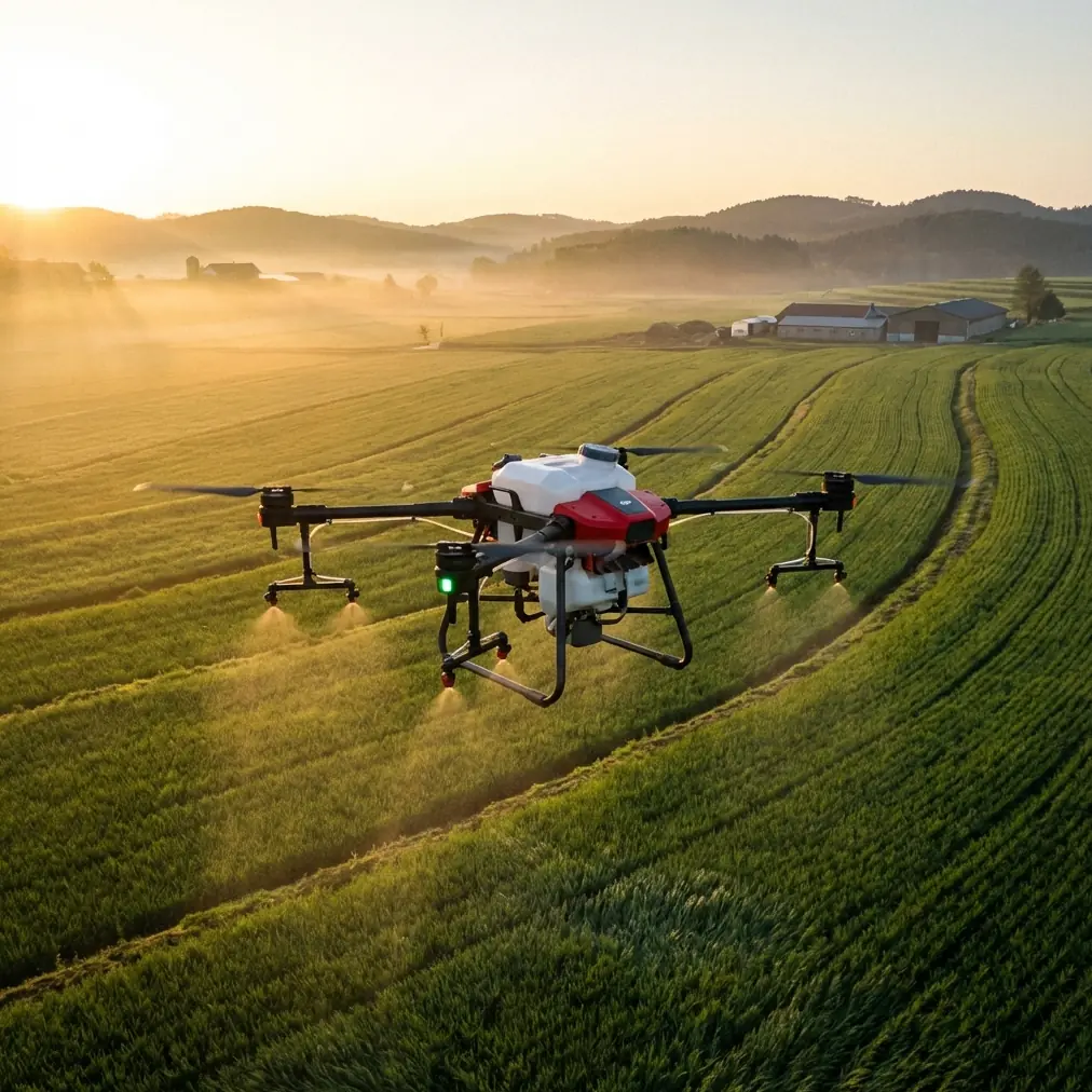
This is where the T70P’s value is not simply that it is a large agricultural platform. Its value is that, when operated correctly, it can turn a fragmented field into a measurable operating map. RTK Fix rate becomes especially important here. On uneven terrain, every weak positional lock compounds downstream error. A poor fix on a narrow terrace edge is not just a data issue. It can lead to overlap waste on one pass and missed coverage on the next.
That is why centimeter precision is not marketing language in this environment. It is practical risk control.
When I advise teams scouting for a later spray mission, I tell them to treat the first flight as a terrain-behavior audit. You are not merely identifying crop condition. You are evaluating how the field itself will interfere with nozzle performance, path regularity, and drift control.
The optimal flight altitude insight for complex terrain
Here is the altitude guidance that matters most in this scenario: for initial scouting over complex terrain, keep the T70P low enough to preserve terrain fidelity, but high enough to avoid chasing every micro-contour with unstable vertical corrections. In practice, that usually means starting around 3 to 5 meters above canopy or target surface for close operational scouting, then adjusting based on slope breaks, crop height variation, and obstacle density.
Why this range?
Fly too high and you flatten the field’s problem areas into a false sense of uniformity. Terrace lips, drainage cuts, and edge vegetation start to blend together. That weakens route planning and can hide the very zones where spray drift or poor deposition will show up later.
Fly too low, and the aircraft spends too much of the mission reacting to abrupt terrain change, rotor wash interaction, and obstacle clutter. In steep or irregular sections, this can reduce flight smoothness and compromise the consistency of the scouting dataset.
The sweet spot is the altitude where the aircraft still “sees” the terrain as a sequence of operational decisions rather than a blur, while maintaining stable control authority. On many hillside or terraced plots, 3 to 5 meters is the right starting band, not a fixed rule. If the canopy is uneven or the field edge is crowded with poles, trees, or raised bunds, move upward incrementally. If you need finer detail for route segmentation, come down carefully and shorten the mission blocks.
This matters because flight altitude is tied directly to what you can do next. Bad altitude choices during scouting produce bad assumptions during spraying.
Spray drift starts during the scouting mindset, not at application time
One of the most common mistakes I see is treating spray drift as a nozzle-only problem. It is not.
Drift risk begins when the operator fails to read the field’s air behavior during scouting. Complex terrain creates localized movement that does not show up in a generic weather reading. A hillside shoulder can accelerate lateral flow. A terrace wall can create a pocket of turbulence. A shaded cut may hold heavier air while a sunlit ridge lifts it.
The practical takeaway for T70P users is simple: use the scouting pass to identify drift-prone sections and build those zones into the application plan. If one side of the field channels air downslope each afternoon, your nozzle calibration and swath width decisions should reflect that before the spray job begins.
Nozzle calibration matters more in these conditions because terrain exaggerates any inconsistency. A setup that appears acceptable on flatter ground may produce uneven deposition when the aircraft transitions across slope changes or narrow terraces. Calibration is not just about output volume. It is about ensuring the droplet behavior and coverage pattern still match the geometry of the field.
In other words, Yunnan’s drone adoption surge should not push operators toward speed alone. It should push them toward better pre-mission discipline.
Swath width is not a maximum number in mountain agriculture
Another operational lesson from complex-terrain scouting: never treat swath width as a static spec to be chased at all costs.
On fragmented plots, the widest theoretical swath often becomes the least efficient real-world choice. Edge losses, overlap on irregular borders, and correction maneuvers can wipe out any paper advantage. A T70P mission in terraced farmland needs a swath width that matches the actual shape of the field and the aircraft’s ability to maintain stable spacing.
This is where careful scouting pays back immediately. If the field narrows at the upper edge, or bends around irrigation channels, you may be better off segmenting the route and narrowing the effective swath rather than forcing one broad pattern across the whole block.
That kind of field-aware planning is exactly what becomes more valuable when a province sees strong drone purchase growth. More aircraft in the market means the average operator baseline rises. The teams that stand out will be the ones who convert hardware capacity into repeatable agronomic precision.
What stable subsidies really change on the ground
The Yunnan government’s commitment to keeping agricultural drone subsidies within the budget and providing support to eligible purchases creates a more stable runway for operators and growers. That sounds administrative, but its field effect is concrete.
Stable subsidy expectations encourage:
- earlier seasonal planning
- more confidence in operator training investment
- stronger maintenance discipline
- broader acceptance of drone-based scouting as a routine farm process
That last point deserves attention. In many regions, drone scouting is still treated as an occasional premium service. In a province where purchases are climbing sharply and policy continuity is explicit, scouting can start becoming standard operating procedure. That changes how farms think about disease detection, stand variability, irrigation issues, and route planning.
For a platform like the Agras T70P, that is the real opportunity. Not more flights for the sake of more flights. Better decisions earlier in the crop cycle.
If you are building a terrain-specific workflow and want a second set of eyes on mission planning, this direct field-ops chat is a practical place to compare notes before deployment.
Where multispectral thinking fits, even if the mission starts simple
Not every T70P field team begins with a multispectral workflow, but the Yunnan trend points toward more sophisticated scouting demands over time. Once operators are already using drone passes to map complex plots and identify operational hazards, the next logical step is richer crop-condition intelligence.
Multispectral analysis can be useful in terrain-heavy agriculture because visual uniformity is deceptive. A slope-facing section may mature differently from a shaded lower terrace. Water movement across elevation breaks can create stress patterns that look random from ground level. Once you understand the terrain through basic scouting, adding multispectral interpretation can help distinguish topography-driven variation from pest or nutrient issues.
The point is not to overload the mission. The point is sequencing. First, master terrain, altitude, RTK stability, and route logic. Then expand the sensing stack as operational maturity grows.
That is exactly the kind of progression that becomes more likely when regional adoption rises and policy signals remain consistent.
The T70P operator’s takeaway from Yunnan’s 2025 signal
Yunnan’s 2025 agricultural drone surge is not a generic low-altitude economy story. It is a stress test happening in one of the more demanding agricultural geographies in China. If purchase numbers are rising sharply there, and if subsidy support remains intentionally stable, then the message for Agras T70P operators is clear: complex terrain is no longer an edge case. It is a proving ground.
To work well in that environment, operators need to think beyond aircraft ownership.
They need high RTK Fix rate consistency, because centimeter precision matters when plots are broken and margins are tight. They need disciplined nozzle calibration, because uneven ground amplifies every application error. They need to treat swath width as a field-specific planning variable, not a bragging point. And they need to choose scouting altitude with care, typically starting in that 3 to 5 meter above-canopy band, then adjusting according to slope, canopy variability, and obstacles.
Most of all, they need to understand what this Yunnan story really represents. When adoption climbs and budget-backed subsidies continue, the market is telling you that drones are moving deeper into core farm operations. The operators who benefit most will not be the ones who simply fly more. They will be the ones who read the field better.
Ready for your own Agras T70P? Contact our team for expert consultation.