Agras T70P Field Report: What Actually Matters for Urban
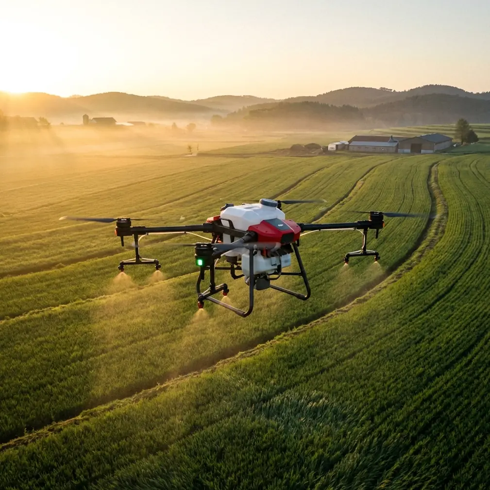
Agras T70P Field Report: What Actually Matters for Urban Vineyard Monitoring
META: A field-driven look at how the Agras T70P fits urban vineyard monitoring, from centimeter-level positioning and nozzle calibration to multispectral scouting, spray drift control, and infrastructure-aware operations.
Urban vineyards expose weak aircraft fast.
Rows are tighter. Boundaries are unforgiving. One side may face a road, the other a retaining wall, drainage channel, footpath, or neighboring property. You are not just trying to cover vines efficiently; you are trying to do it without drift, without missed sections, and without wasting time around obstacles that a broad-acre workflow would barely notice.
That is why the Agras T70P deserves to be discussed as a monitoring platform, not only as a field machine. In compact viticulture settings, especially those pressed into urban or peri-urban edges, the best UAV is the one that can switch between data collection logic and treatment logic without forcing the operator into compromises.
I have spent enough time around vineyards to know that growers rarely ask for “more technology.” They ask for cleaner decisions. Which rows are lagging? Is vigor loss tied to water stress, disease pressure, or a blocked irrigation zone? Are we seeing structural issues near a wall, culvert, or embankment? Can the drone fly repeatable paths close enough to be useful without creating a drift problem next to sensitive areas?
Those questions matter more than headline specs. They also connect directly to how drones are already being used in civilian technical work beyond agriculture. Reference material on UAV development highlights several mature uses that map surprisingly well onto vineyard operations: high-resolution terrain capture, digital mapping, infrastructure scanning, and environmental monitoring. That broader context matters because an urban vineyard is not just a crop block. It is a layered site with topography, structures, drainage behavior, and ecological constraints all interacting at once.
Why the T70P fits the urban vineyard problem
The strongest case for the Agras T70P is not that it can do one thing exceptionally. It is that it can support a more disciplined workflow in places where errors are expensive.
In a standard open field, a small positioning deviation may be tolerable. In an urban vineyard, it can mean overlap onto a path or under-application on a narrow edge row. That is where centimeter precision and RTK fix rate stop being spec-sheet decoration. They become operational safeguards.
If the aircraft holds a strong RTK fix and maintains repeatable line tracking, the operator can revisit the same rows for scouting, compare changes over time, and execute work near edges with far more confidence. Competitors often look similar in broad marketing terms, but many begin to show inconsistency when the worksite gets cluttered and the mission depends on exact row-by-row repeatability. The T70P’s advantage, in this context, is not raw force. It is controllable precision.
For vineyards bordered by buildings or mixed-use infrastructure, that repeatability reduces three common problems:
- Uneven row coverage caused by slight path drift
- Extra chemical exposure risk near property boundaries
- Poor data comparison between flights because the aircraft did not follow the same geometry twice
That third point gets overlooked. Monitoring only becomes trustworthy when the aircraft can return to the same corridor and generate comparable observations. Otherwise, operators end up chasing differences created by flight inconsistency rather than plant condition.
Monitoring is not separate from spraying
A lot of drone discussions split “survey” and “application” into separate categories. In the field, they are linked. The same site conditions that complicate spraying also complicate interpretation.
The source material on UAV applications describes how drones are used for ecological investigation through wildlife observation, vegetation monitoring, and water environment data collection. It also describes their role in geological and engineering inspection, including rapid scanning of structures, bridges, canals, and built zones to detect defects, water leakage, or pollution issues. That matters to an urban vineyard because many vineyard health problems are not purely botanical.
A weak section in a vine block may come from a drainage fault. A repeated stress pattern may trace back to terrain variation. An edge-row issue may reflect reflected heat from nearby construction. A low area may hold moisture differently after irrigation or rainfall.
Drones became valuable in scientific research because they collect site-level evidence quickly and efficiently. The same logic applies here. If the Agras T70P is paired with a multispectral workflow, it can help identify variation in canopy vigor across rows. If that is then interpreted alongside terrain and structural observations, the operator gets something far more useful than a colorized map: a probable cause.
That is the threshold between gadget use and professional use.
The real significance of multispectral in vineyards
Urban vineyard monitoring benefits from multispectral imaging, but only if the operator understands what problem it is solving.
The reference document notes that UAVs equipped with multispectral sensors can capture vegetation at different wavelengths and use data analysis to estimate coverage and growth condition. In research terms, that supports ecological restoration. In vineyards, it helps isolate canopy inconsistency before it becomes visually obvious from the ground.
For the Agras T70P operator, this creates a practical sequence:
- Fly repeatable routes with strong positional consistency
- Capture multispectral variation across vine rows
- Compare hotspots of low vigor against irrigation layout, terrain slope, and edge conditions
- Adjust treatment or scouting priorities rather than blanket-applying everything equally
This is where the T70P can outperform lesser platforms used in similar roles. Some competing systems can collect imagery, but the workflow breaks down if the aircraft cannot maintain precise corridor alignment or if integration between scouting insight and treatment planning is clumsy. In an urban vineyard, every unnecessary pass and every extra minute over a sensitive boundary increases operational friction.
A good drone should shorten the distance between observation and action.
Spray drift is the issue nobody can afford to treat casually
If you monitor vineyards in urban settings, spray drift is not an abstract compliance topic. It is the central operational constraint.
The usual mistake is to talk about drift only in terms of wind. Wind matters, of course, but drift control is also shaped by nozzle calibration, flight height, speed stability, droplet behavior, and how consistently the aircraft holds its line near edges and obstacles.
That is why nozzle calibration deserves more attention than it gets. On the T70P, calibration discipline is the difference between using technology well and merely using it. If the aircraft is flown with accurate positioning but the output is poorly tuned, the result is false confidence: clean flight logs, messy coverage.
In urban vineyards, proper nozzle calibration helps with three things at once:
- matching droplet profile to canopy density
- reducing off-target movement near roads, paths, and neighboring properties
- preserving treatment consistency from row to row
This is another area where some competitor platforms underperform in practice. They may advertise capacity or speed, but they often feel less composed when the job requires careful edge management rather than brute throughput. The T70P makes more sense when the goal is controlled application integrated with mapping and repeatable route planning.
Swath width also needs a vineyard-specific interpretation. Bigger is not always better. In broad-acre crops, maximizing swath width can raise efficiency. In urban vine blocks, overly aggressive width assumptions may create uneven deposition at row edges or tempt operators into flight plans that ignore the geometry of trellised planting. A platform like the T70P works best when swath width is treated as a variable to be tuned around canopy structure, not a vanity metric.
Terrain, drainage, and why mapping still matters
One of the most useful points in the reference text is the mention of UAV-generated high-resolution topographic imagery and digital terrain models, including 3D mapping. That capability is often filed under surveying, but in vineyards it has direct management value.
Urban vineyard sites are rarely uniform. They may include stepped grades, retaining structures, service roads, culbs, stormwater channels, or disturbed construction margins. A drone-generated terrain model can reveal why one section repeatedly underperforms, why runoff collects at a row end, or why irrigation distribution is behaving differently than expected.
This is not theoretical. If you can overlay vine vigor patterns with elevation and drainage pathways, you stop treating symptoms in isolation.
The T70P becomes particularly useful when it is part of a system that can document these recurring patterns over time. Centimeter precision improves the reliability of those comparisons. You are not just building a pretty map; you are building a site memory.
For consultants like me, that is where client trust is won. Not by flashy screenshots. By being able to say: this stress pattern aligns with a low spot visible in the terrain model, and the same area also shows moisture persistence near the drainage line. That is a different conversation from “some vines look weak.”
Infrastructure awareness is a hidden advantage
The same source material also points out that UAVs can rapidly scan structures and engineered zones to detect defects, leakage, and pollution concerns. That sounds far removed from vineyard work until you remember how many urban vineyards sit beside man-made infrastructure.
Walls crack. Drain lines clog. Canals leak. Adjacent surfaces reflect heat. Access roads reshape runoff.
A drone platform that can monitor vine performance while also supporting inspection of the surrounding site is more valuable than one designed only to fly a crop recipe. In compact vineyards, the environment around the vines often explains the behavior of the vines themselves.
This is where the T70P has an edge over systems built with a narrower field-ag mindset. A more capable workflow lets the operator move from crop symptom to site diagnosis without changing tools entirely. That saves time, but more importantly, it reduces blind spots.
Weather resistance and daily usability matter more than people admit
IPX6K is one of those details that sounds technical until the season gets messy.
Urban vineyard work does not always happen in ideal conditions. Dust from nearby roads, splash exposure during cleaning, residue accumulation, and damp starts can all shorten the life of less robust equipment. IPX6K protection does not mean the operator can ignore maintenance or common sense, but it does signal that the aircraft is built for field reality rather than showroom logic.
That matters because monitoring programs are only useful if the drone is ready when the crop window is. Disease pressure, irrigation faults, and canopy changes do not wait for perfect weather or pristine launch zones.
Reliability is part of data quality. Miss enough flights and your trendline breaks.
What a practical T70P workflow looks like in an urban vineyard
For most operators, the best results come from a disciplined sequence rather than a single heroic flight.
Start with a baseline map. Use the drone to define row geometry, boundaries, terrain breaks, drainage paths, and adjacent infrastructure. Build a site model that reflects the vineyard as it actually exists, not as it appears on an old plan.
Next, run repeatable monitoring missions. If multispectral data is available, use it to flag variation in canopy vigor, growth uniformity, and possible stress zones. Compare those zones with topographic and infrastructure context.
Then decide what deserves intervention. Not every weak patch needs the same response. Some need agronomic treatment. Some need irrigation correction. Some need physical site repairs. This is where drone-derived data earns its place.
Only then should application parameters be finalized. That means checking nozzle calibration, reviewing drift exposure at sensitive edges, adjusting swath width to canopy and row spacing, and confirming that RTK performance is stable enough for precise route execution.
That sequence sounds methodical because it is. The T70P is at its best when used by operators who think like managers, not just pilots.
If you want to compare workflows or discuss urban vineyard setups in more practical detail, you can message Marcus directly here.
Final assessment
The Agras T70P makes the most sense in urban vineyard monitoring when precision, repeatability, and site-awareness matter more than headline speed alone.
Its value is not limited to crop application. The stronger argument is that it supports a fuller operational loop: terrain capture, repeatable scouting, multispectral interpretation, edge-sensitive planning, and controlled execution. The reference material on UAV use in scientific research and technical inspection reinforces this perfectly. Drones are most powerful when they do not just observe crops, but reveal the environmental and structural context shaping crop performance.
Two details from that material stand out. First, UAVs using multispectral sensing can assess vegetation condition across different wavelengths, which directly supports earlier detection of canopy variability in vineyards. Second, UAVs can generate high-resolution terrain data and 3D digital maps, which helps explain drainage patterns, slope effects, and recurring stress zones. Add in the documented role of drones in scanning engineered structures for defects or leakage, and the urban vineyard use case becomes even clearer.
That is why the T70P deserves serious attention. Not because it is a generic farm drone, but because it fits the layered reality of vineyards surrounded by infrastructure, boundaries, and environmental sensitivity.
Ready for your own Agras T70P? Contact our team for expert consultation.