Agras T70P in Complex Terrain: What Serious Monitoring Work
Agras T70P in Complex Terrain: What Serious Monitoring Work Really Demands
META: A technical review of how Agras T70P fits complex-terrain agricultural monitoring, from five-minute hillside logistics to hyperspectral soil analysis, GIS workflows, RTK precision, and field-ready decision-making.
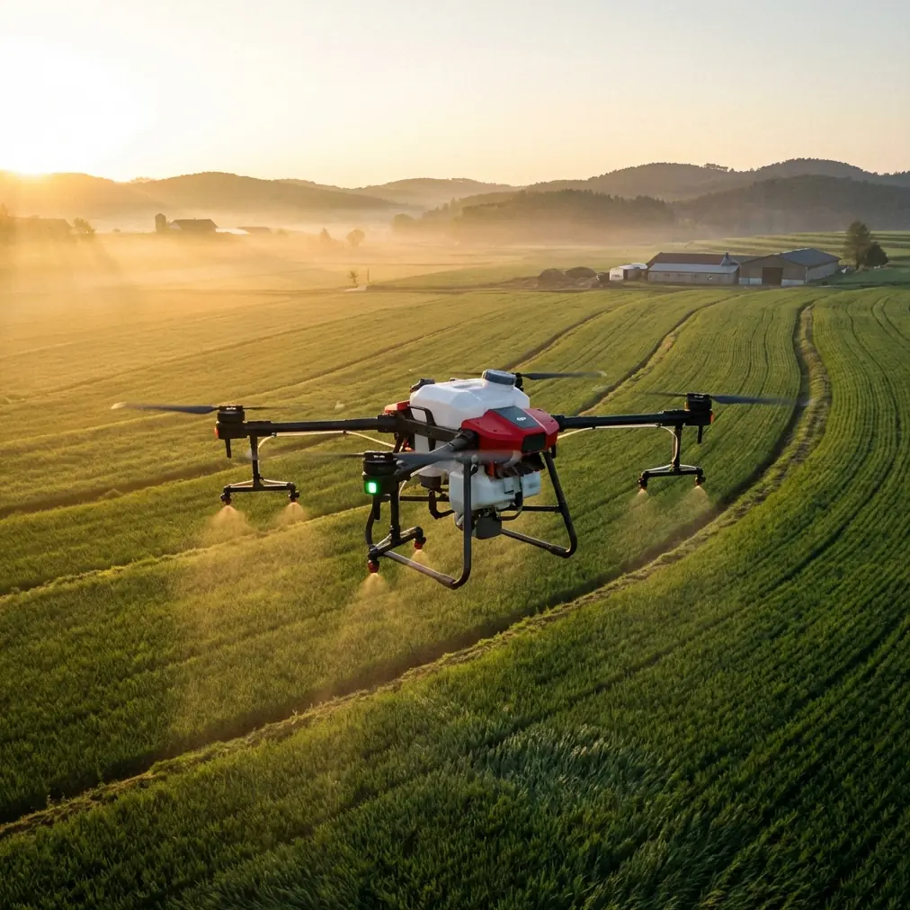
The most revealing way to assess the Agras T70P is not to start with a brochure spec sheet. Start with a hill.
In one recent loquat-growing case, fruit reportedly moved downhill by drone in just 5 minutes. On the same day, a livestream sales campaign tied to that produce generated nearly 6,400 orders and 450,000 yuan in sales, a sixfold increase over the previous year’s event. Those are commercial numbers, but they also tell a technical story. When a farm sits in difficult terrain, the bottleneck is rarely just production. It is access, timing, and the ability to make decisions before the slope, weather, or labor window closes.
That is where the Agras T70P becomes interesting as a monitoring platform. Not because it replaces every specialized sensor aircraft. It does not. And not because complex terrain magically becomes simple once a rotorcraft is in the air. It doesn’t. The value is that a platform in this class can sit at the center of a real operating system for hillside agriculture: observe conditions, support intervention timing, and compress the time between field status and field action.
For growers and service providers managing orchards, terraced blocks, and fragmented fields, that difference is operational, not theoretical.
Why complex terrain changes the drone conversation
Flat farmland rewards scale. Hillsides reward adaptability.
In steep or broken ground, the monitoring challenge compounds fast. Swath width can become misleading because the useful coverage pattern changes with elevation shifts and irregular canopy edges. RTK fix stability matters more because centimeter precision on a slope has direct consequences for route fidelity, overlap quality, and treatment placement. Spray drift risk becomes more complicated because airflow, canopy gaps, and terrain-induced turbulence don’t behave like they do in open rectangular fields.
Agras platforms are usually discussed for spraying or spreading, but that framing is too narrow for the T70P in mountainous agriculture. In practice, serious operators need a drone that can support the full loop:
- identify what is happening,
- locate it accurately,
- share the data quickly,
- act before conditions change.
Monitoring is only useful when it shortens the response cycle.
The loquat example is useful precisely because it shows how fast that cycle can move once drones are integrated into the terrain itself. Five-minute downhill transport is not just a logistics anecdote. It demonstrates that the physical isolation of hillside production can be reduced enough to affect commercial outcomes. If transport friction drops, then scouting, treatment timing, disease checks, and harvest-quality decisions can all be pushed closer to real time.
What the T70P needs to prove in a monitoring role
For a platform like the Agras T70P, complex-terrain monitoring is not about flying once and generating pretty imagery. It is about consistency under field pressure.
That means the following matter more than marketing phrases:
1. Route discipline on slopes
If a field team is relying on repeatable flight paths over uneven ground, RTK fix rate becomes a foundational performance marker. Centimeter-level positioning is not just a mapping luxury. In orchards and terraced fields, it supports repeat visits over the same rows, improves the reliability of comparative observations, and reduces the chaos that comes from manually improvising every mission.
On a hillside, a weak position solution can cascade into uneven overlap, poor geo-alignment of observations, and less confidence in where a problem actually sits. If you are trying to compare stress patches week over week, “roughly there” is not enough.
2. Environmental toughness
Readers evaluating the T70P for long field days should pay attention to ruggedization standards such as IPX6K. In complex agricultural environments, monitoring flights do not happen in a lab. They happen around mud splash, washdown routines, fertilizer dust, humid dawn conditions, and the residue that accumulates when a drone is serving multiple field functions.
A high environmental protection standard is not glamorous, but it affects uptime. Uptime affects data continuity. And continuity is what separates a useful monitoring program from a stack of disconnected sorties.
3. Drift-aware application feedback
Even when the primary mission is monitoring, spray operations remain part of the same decision chain. That is why spray drift and nozzle calibration still belong in the review.
A monitoring workflow that flags canopy stress, nutrient unevenness, or localized disease pressure only creates value if the follow-up application is controlled. In broken terrain, poor nozzle calibration can distort treatment rates across elevation changes and row geometry. Drift risk can turn a precise diagnosis into a messy intervention. The T70P’s practical role, then, is not merely to spot variability but to help link that variability to disciplined response planning.
That is the difference between drone adoption and drone system management.
A more realistic view of sensing: not every answer comes from RGB
One of the strongest clues in the reference material has nothing to do with direct product marketing. It comes from hyperspectral remote sensing research.
The cited source explains that objects not distinguishable in conventional remote sensing can become identifiable in hyperspectral curves, increasing the information available for inversion and analysis. It also notes that for soil organic matter, absorption features in the 550–700 nm range are strongly associated with organic content. That detail matters because soil organic matter is not just an academic variable; it is one of the clearest indicators of fertility and long-term field condition.
Here is the practical takeaway for T70P users in complex terrain: the drone’s value grows when it is treated as part of a layered sensing strategy.
If you are monitoring hillside production venues, standard visual inspection can tell you where there is visible stress. A multispectral workflow can push farther by separating vigor patterns that the eye may miss. Hyperspectral methods, where available, can reveal subtler relationships in soil and vegetation signatures that conventional imaging often cannot resolve. The reference also makes an essential caution: soil spectral response is not universal because soils differ by climate, parent material, terrain, biology, age, and human activity.
That warning should shape how Agras T70P operators think.
Do not assume that one spectral model built in one valley will transfer cleanly to another mountain block. Local calibration still matters. If you want meaningful outputs from a multispectral or advanced sensing workflow, ground truth and site-specific interpretation are not optional. They are the whole job.
Field significance of soil organic matter in steep agriculture
The source document is direct: soil organic matter is a key indicator of soil fertility. For complex-terrain farms, its monitoring carries extra weight.
Why? Because hillsides often show stronger within-site variability than flat fields. Runoff patterns, shallow soils, exposed shoulders, deposition zones, and differing sun exposure all create uneven soil performance. A drone-led monitoring program can help identify those patterns faster than scattered manual checks, especially when imagery is tied to geospatial processing.
This is where the T70P discussion should move beyond aircraft alone and into workflow architecture.
The ArcGIS reference gives a practical template:
- Drone2Map is used to stitch drone imagery into high-resolution orthomosaics.
- ArcMap can place geotagged photos onto the map and combine imagery, sample plots, and field boundaries in one workspace.
- ArcGIS Portal enables data sharing between field and office teams.
- Even the hardware guidance is grounded and useful: a processing machine should have a CPU better than 4 cores, at least 4 GB memory, and at least 500 GB storage, with a strong GPU preferred when the photogrammetry software uses GPU computation.
This might sound ordinary, but it is exactly how monitoring programs become repeatable. A drone flight without a downstream structure is just aviation. A drone flight connected to orthomosaic generation, sample-point interpretation, GIS layering, and internal data sharing becomes management infrastructure.
For a T70P operator working in complex terrain, that infrastructure matters as much as the aircraft.
The hidden bottleneck: turning flights into decisions
Many agricultural drone programs stall at the same point. The aircraft flies. Data is collected. Then everything slows down.
The ArcGIS workflow references are a reminder that timely interpretation is often the limiting factor. If imagery can be stitched quickly in Drone2Map, sample photos can be anchored spatially in ArcMap, and outputs can be distributed through ArcGIS Portal, then agronomists, managers, and operations staff can work from the same map instead of arguing over screenshots in a chat thread.
That matters more in mountainous production than on broadacre plains. A steep site usually has tighter labor windows, harder access, and less tolerance for delayed decisions. A team that can inspect a block, process imagery, and share actionable maps the same day has a measurable edge.
For teams building that kind of workflow around the T70P, this is a useful checkpoint: if your internal process cannot move from flight to interpreted map quickly, the aircraft is not the main constraint anymore.
A sensor moment that says more than a spec sheet
During one hillside venue inspection, the kind of thing that exposes whether a drone system is truly field-ready happened without warning: a small muntjac deer broke from brush near the terrace edge and crossed beneath the flight path just as the aircraft was transitioning along a contour line. This is where stable sensing, terrain awareness, and disciplined operator response matter. The drone did not lurch into a confused correction or force an abandoned mission. It held the line, the pilot adjusted safely, and the team preserved both the survey continuity and the buffer around the animal.
That sort of moment never appears in glossy product pages. But it is exactly the test that matters in complex terrain. Real monitoring environments are alive. Birds rise unexpectedly. Mammals move through orchard margins. Workers appear between rows. The value of a platform like the Agras T70P is inseparable from how calmly its sensing and control stack helps the operator deal with those interruptions.
Where the T70P fits best
Based on the reference materials and the reader scenario, the Agras T70P makes the most sense when it is used as the central field machine in a broader terrain-adapted monitoring system.
That system looks like this:
- high-frequency field observation in fragmented or steep agricultural venues,
- accurate geolocation supported by strong RTK performance,
- disciplined application planning with attention to drift and nozzle calibration,
- optional multispectral or advanced spectral workflows for deeper crop and soil interpretation,
- GIS-backed processing and distribution so office and field teams work from the same evidence.
The commercial story from the loquat case and the scientific story from the hyperspectral research actually point in the same direction. One shows what happens when drone-enabled terrain compression changes the economics of a hillside product chain. The other shows that smarter sensing can reveal field conditions conventional observation may miss, especially around fertility-related variables like soil organic matter.
Put together, they define the real question buyers and operators should ask about the T70P:
Not “Can it fly here?” But “Can it help this site observe, interpret, and respond fast enough to matter?”
If you are evaluating the platform for complex-terrain monitoring and want to compare workflow design, sensor choices, or field deployment logic, you can continue the discussion here: https://wa.me/85255379740
That is the standard worth using. In steep agriculture, the best drone is the one that shortens the distance between what the field is telling you and what your team does next.
Ready for your own Agras T70P? Contact our team for expert consultation.