How the Agras T70P Fits a Smarter Coastal Field Monitoring W
How the Agras T70P Fits a Smarter Coastal Field Monitoring Workflow
META: A practical expert look at using the Agras T70P for coastal field monitoring, with lessons from drone mapping, image management, and field-level source control in agriculture.
Coastal farming exposes every weak link in a monitoring workflow.
Wind shifts fast. Salt air shortens maintenance intervals. Field edges are irregular, drainage patterns change after heavy weather, and small planting differences can turn into large management problems if they are spotted too late. For operators evaluating the Agras T70P, the real question is not whether a drone can fly over fields. It is whether the aircraft can become part of a dependable decision system that tells you what is happening, where it is happening, and what to do next.
That is where the most useful lesson from recent Chinese agricultural drone practice becomes relevant. In Zhuxi County, the local tobacco authority used drone mapping to strengthen source control for tobacco fields. What stands out is not the aircraft alone. It is the way the mapping outputs were fused into a full-chain management model, tying aerial data to contract management, supply allocation, and disaster prevention. The operational significance is obvious: once a team can accurately understand the planting status of each individual plot, supervision stops being broad and reactive. It becomes plot-specific and timely.
For coastal growers and agronomy teams considering the Agras T70P, that idea matters more than any spec sheet headline.
The real coastal problem: visibility breaks before operations do
In coastal regions, field monitoring usually fails in one of three places.
First, the field record does not match the field itself. A boundary may have shifted, a drainage channel may have widened, or a planted section may be underperforming without being reflected in current maps.
Second, aerial data gets collected but not organized. Teams fly missions, save orthomosaics, tag a few sample points, and then lose time trying to retrieve the correct image from the correct week at the correct resolution.
Third, treatment decisions are made without enough positional confidence. In windy coastal conditions, spray drift risk rises quickly. If nozzle calibration is inconsistent, or the swath width assumption is too optimistic, even a capable aircraft can create uneven coverage or waste product.
The T70P is most valuable when it is used to close all three gaps at once: field truth, data continuity, and application accuracy.
What the Zhuxi case gets right
The Zhuxi tobacco example deserves attention because it treats drone mapping as infrastructure, not as a one-off inspection exercise.
The source material states that mapping data was deeply integrated with contract management, material supply, and disaster mitigation work. That is a serious operational shift. In plain terms, a map is no longer just a picture. It becomes a control layer for planning seedling inputs, validating planting status, and responding faster when weather damage hits.
That same structure translates well to coastal monitoring with the Agras T70P.
Imagine a coastal farm block where different sections have different exposure to wind, salinity, and standing water. If the T70P mission data is linked to input schedules and risk flags, managers can move from general assumptions to field-by-field intervention. One section may need follow-up scouting because canopy vigor dropped after a storm surge. Another may need application timing adjusted because persistent crosswinds raised spray drift concerns near a drainage edge. Another may reveal a mismatch between planned and actual planted area, which affects both supply forecasting and yield expectations.
The drone does not solve those issues by itself. It provides the spatial evidence to manage them correctly.
Why image management is not optional once monitoring scales
This is where the ArcGIS field-and-office integration reference becomes unusually useful.
The document notes that a city- or province-level survey can generate thousands of orthophotos in a single census cycle. Over multiple years, that archive expands rapidly, and an image management system reduces management cost while making the data more usable. That point often gets ignored by smaller agricultural operators until they hit the wall themselves. The first ten flights feel manageable. The next hundred expose the problem.
For a T70P monitoring program in coastal agriculture, the image library becomes the memory of the farm. Without disciplined storage and metadata, teams cannot reliably compare pre-storm and post-storm conditions, isolate recurring weak zones, or trace whether a vegetation issue is new or persistent.
The same ArcGIS reference also points out that Portal for ArcGIS can share orthophotos, sample points, and oblique models across teams and devices. Operationally, that is huge. Coastal field management is rarely handled by one person. Agronomy staff, operations managers, input coordinators, and sometimes insurers or landowners all need different views of the same reality. A shared geospatial portal turns the T70P from a field tool into a collaboration node.
If you are monitoring coastal fields, that means a scouting observation does not stay trapped on one pilot’s tablet. It can become a layer everyone works from.
The hidden precision issue: map offset before takeoff
One of the most practical details in the ArcGIS solution is the warning that satellite imagery in China can have positional offset, and that operators should enable the domestic map setting in DJI GO and Altizure before takeoff to improve task sample locating and flight range planning.
This may sound minor. It is not.
When operators discuss centimeter precision or RTK Fix rate, they often focus on the aircraft and GNSS performance. But mission planning can already be compromised if the base map itself is shifted. In coastal field monitoring, where drainage lines, levees, narrow access strips, and crop edges matter, a planning offset creates downstream error. The swath width may be technically correct, yet assigned to the wrong edge. Sampling points may look aligned in software but miss the exact stress zone on the ground. Follow-up application routes can become less efficient.
So yes, centimeter precision matters. But it starts with respecting the whole chain: basemap accuracy, route planning, positioning stability, and post-flight data alignment.
For T70P operators, that is the difference between a workflow that feels advanced and one that actually produces dependable agronomic decisions.
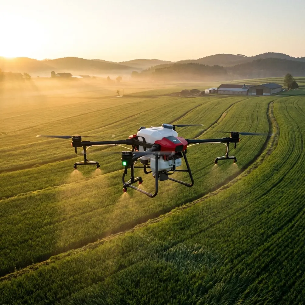
The Agras T70P in a monitoring role, not just an application role
The Agras line is often discussed primarily in terms of treatment work. That misses half the value.
A coastal operation using the T70P should think in two loops. The first is observation: mapping field condition, identifying anomalies, tracking stand uniformity, recording boundaries, and comparing changes over time. The second is response: adjusting application timing, refining nozzle calibration, managing drift exposure, and documenting what was treated and why.
Those loops must feed each other.
This is especially relevant in mixed weather windows near the coast. An aircraft may be ready to fly, but treatment quality can still be compromised by unstable wind at low altitude. In that setting, a monitoring pass can prevent a poor application decision. If vegetation stress is localized rather than whole-field, you preserve inputs. If standing water has spread along one side of the block, you change route logic. If a storm front passed overnight, you capture visual evidence first and act second.
That sequence is how high-output drone programs avoid expensive mistakes.
A field moment that says more than a brochure ever could
On one coastal inspection, the pilot had lined up a low pass along a boundary ditch just after sunrise. The field looked clear from the truck. Halfway through the route, a cluster of egrets lifted from the reeds and crossed the edge of the mission area. The aircraft’s sensing system reacted cleanly, and the operator paused the pass rather than forcing the line.
That kind of wildlife encounter is common near waterlogged margins, estuary-adjacent farms, and paddy-style edges. It is not a dramatic story. It is a normal one. And it reveals something practical: coastal field monitoring is dynamic, not laboratory neat. Sensors, pilot judgment, and route discipline all matter because the environment is alive. A good T70P workflow accounts for those interruptions instead of pretending they do not exist.
That also reinforces why post-flight review is essential. If a route break happened near a sensitive field edge, the team should verify whether coverage, imagery continuity, or sampling completeness was affected. Monitoring quality lives in those details.
Why agriculture keeps pulling drone development forward
The industry analysis in the reference material includes one number that deserves a closer look: XAG was reported to have already served 500,000 mu in Xinjiang, against a broader Chinese market measured in 1.8 billion mu. The exact competitive landscape has evolved since that snapshot, but the significance remains. Agriculture is not a side market for drones. It is one of the environments where scale, repeatability, and measurable return are easiest to prove.
The same document also notes that load-carrying drone operations demand stronger flight control, stability, and cruising capability than mainstream light UAV use. That matters for anyone considering a T70P in coastal conditions. Sea-adjacent winds, humidity, and broad field runs expose weaknesses quickly. Stability is not just a comfort feature. It shapes deposition consistency, route fidelity, and battery-to-acre efficiency.
And while the logistics section of that report talks about sub-2-kilogram delivery opportunities, the more relevant lesson for agriculture is simpler: once a drone system can repeatedly perform useful work at scale, the market expands around reliability, not novelty.
That is exactly the frame coastal operators should use for the T70P.
Building a coastal monitoring stack around the T70P
A sensible T70P deployment for coastal fields usually looks like this:
Establish clean field geometry Update boundaries after drainage changes, storm impacts, or seasonal land reshaping. If there is any basemap offset risk, correct the planning environment before flying.
Capture repeatable imagery Fly on a schedule tied to crop stage and weather events, not random convenience. The goal is comparability.
Tag observations to location If multispectral data is available in the wider workflow, use it to support stress interpretation, but do not neglect simple visual orthophoto review. Many drainage, stand, and salinity clues are spatial before they are spectral.
Store outputs in a searchable system The ArcGIS reference is right: once images scale into the hundreds or thousands, metadata-driven retrieval stops being a luxury.
Connect monitoring to action Link the mapped evidence to application planning, nozzle calibration logs, spray drift precautions, and field-by-field treatment records.
Review after major weather Coastal farming punishes assumptions. Re-fly after extreme wind or rain events and compare against the previous layer.
If your team is still deciding how to structure that workflow around the T70P, this field planning chat link is one practical way to discuss route logic, data handoff, and coastal operating considerations.
What separates useful drone monitoring from expensive image collection
The answer is integration.
The Zhuxi tobacco case proves that aerial mapping becomes valuable when it is embedded in management. The ArcGIS material proves that scaling creates a data organization problem as surely as it creates a flying problem. The industry report reminds us that agricultural UAV adoption grows where operators can translate airborne capability into repeatable field results.
So if you are looking at the Agras T70P for coastal monitoring, do not ask only how much area it can cover or how stable it is in wind. Ask tougher questions.
Can it help you verify every planted block with confidence?
Can your team retrieve the right orthophoto from the right week without wasting half a day?
Can mapped anomalies be tied directly to material planning, disaster response, and follow-up application decisions?
Can your RTK Fix rate, nozzle calibration discipline, and drift management practices support the precision your maps imply?
That is the standard that matters.
Used that way, the T70P stops being just a flying machine over fields. It becomes part of a field intelligence system—one that is especially valuable in coastal agriculture, where conditions change faster than paperwork ever can.
Ready for your own Agras T70P? Contact our team for expert consultation.