Agras T70P Mapping Tips for Urban Vineyards: A Field
Agras T70P Mapping Tips for Urban Vineyards: A Field-Driven Case Study
META: Practical Agras T70P mapping guidance for urban vineyards, with antenna positioning, RTK stability, spray drift control, nozzle calibration, and workflow tips that improve precision.
Urban vineyards punish lazy flight planning.
Rows are tight. Trellises create repeating visual patterns that can confuse weaker positioning workflows. Nearby buildings reflect signals. Roads, fences, utility lines, and tree belts compress your margins. If you are trying to map a vineyard block in or near a built-up area with the Agras T70P, success is less about theoretical capability and more about how well you control small variables that stack into usable data.
This is where operators often make a category error. They treat the T70P as if mapping quality begins and ends with route automation. It does not. In vineyard environments, especially urban-edge vineyards, mapping quality starts before takeoff: antenna placement, RTK stability, weather judgment, nozzle setup if the mission will progress into spraying, and a realistic view of swath width against row geometry.
I want to frame this as a case study rather than a generic how-to. The scenario is familiar. A grower needs a repeatable map of vine vigor variation across a fragmented vineyard bordered by roads and light industrial buildings. The goal is not simply to generate an attractive orthomosaic. The goal is to produce a map that can support practical decisions: where canopy growth is lagging, where irrigation uniformity may be slipping, and how to follow up with precise treatment without worsening spray drift risk in a sensitive urban setting.
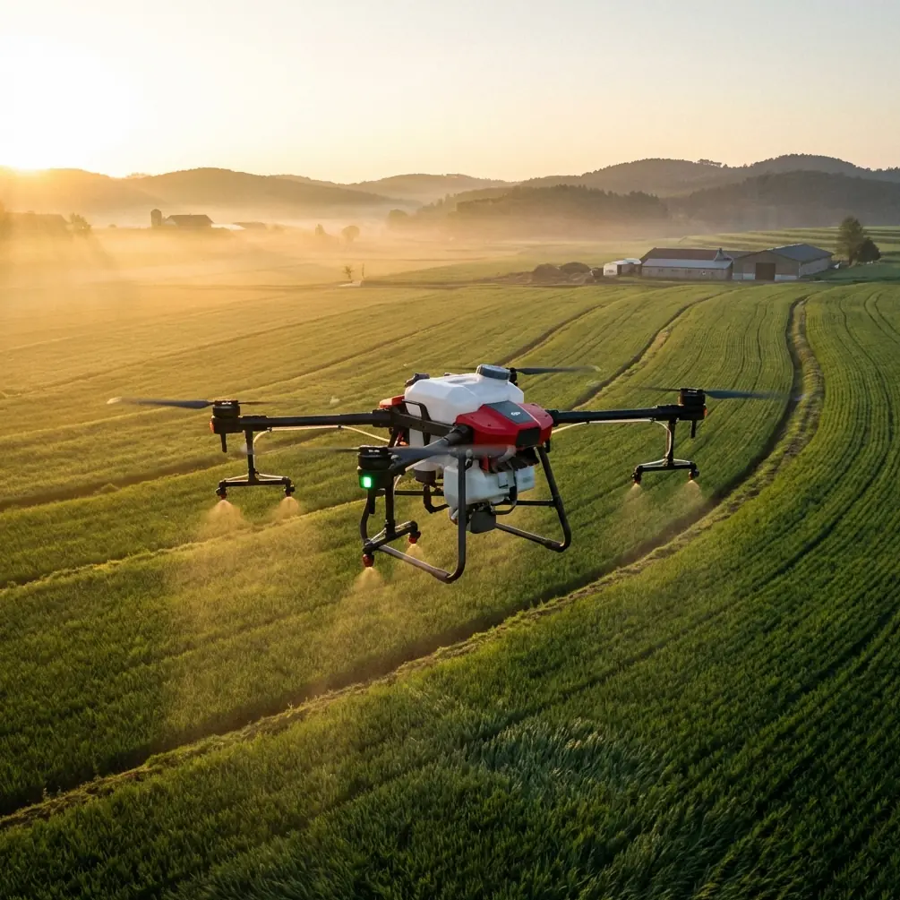
The Agras T70P is not usually discussed first as a mapping platform. That is exactly why disciplined workflow matters here. If you want useful vineyard intelligence from it, you need to fly and set up like an agronomy professional, not like someone collecting pretty aerial images.
The first operational issue is RTK fix rate. In urban vineyards, centimeter precision is not a luxury. It is the difference between a map that aligns with a specific row segment and one that drifts just enough to muddy interpretation. Vineyards are unforgiving because the crop itself is organized into narrow, repeating bands. Small horizontal errors can make one pass appear to belong to the adjacent row, especially when you compare flights over time.
If your RTK fix is inconsistent, the data may still look acceptable at a glance. That is the trap. The problem appears later when you try to compare vigor patterns, flag missing vines, or target follow-up work. A map with unstable positioning does not only reduce confidence; it creates false patterns. In research settings, that kind of positional instability can contaminate a trial. In commercial operations, it wastes labor because the field team goes out to investigate problems that are artifacts of the flight.
For that reason, antenna positioning deserves more attention than it gets. My advice for maximum range is simple and practical: place the base or receiving antenna where it has the clearest possible sky view above rooflines, vehicle traffic, and metal clutter, and keep it well away from structures that can create multipath reflections. In urban-edge vineyards, a poor antenna location can look “fine” before launch yet degrade as the aircraft moves behind a line of buildings or mature shelter trees. Elevation helps, but clean horizon exposure matters more than simply putting the antenna on the tallest object available. A tripod location on open ground beside the block often outperforms a rooftop corner crowded by HVAC units, rails, and reflective surfaces.
Orientation matters too. Avoid positioning the antenna close to chain-link fencing, parked machinery, or stacked irrigation pipe. Those are classic sources of signal reflection and degradation. If the block is elongated, set the antenna so the aircraft maintains line-of-sight through the longest working corridor rather than the nearest convenient setup point. Maximum range is not only a radio question. It is a geometry question.
Once the RTK foundation is stable, the second major issue is swath width. In broadacre work, operators often think in terms of coverage efficiency first. In vineyards, that instinct can get you into trouble. The right swath width is the one that preserves row-level interpretability and safe maneuvering margins, not the widest pattern the aircraft can technically achieve.
A narrow, well-controlled swath is often the better choice in urban vineyards because it reduces ambiguity at row edges and helps maintain cleaner overlap where trellis shadows and mixed surfaces already complicate image consistency. This matters even more if your ultimate intent is to connect mapping results to treatment zones. A sloppy swath decision in the mapping stage can ripple forward into poor operational targeting later.
Now add the multispectral question. Many vineyard managers are rightly interested in multispectral outputs because vine stress rarely announces itself uniformly across a block. Yet the real value is not in saying “multispectral is useful.” The value comes from understanding what it can and cannot resolve in vineyards hemmed in by urban surfaces.
Built structures, gravel lanes, bare soil strips, and reflective roofs can all introduce spectral contamination near boundaries. If your block includes edge rows next to roads or buildings, do not assume those rows will behave like the interior. Interpreting vigor from multispectral data without accounting for edge effects can lead you to misdiagnose stress. Sometimes that weak-looking row is not a nutrition issue at all; it is a spectral and shading artifact caused by adjacent infrastructure.
This is why I recommend using the interior rows as your baseline and treating border rows as a separate analytical category. It sounds conservative. It is also how you avoid bad agronomic conclusions.
The T70P’s environmental durability is part of the story as well. An IPX6K rating matters in real agricultural operations because vineyard work is dirty, wet, and rarely timed to laboratory conditions. Morning dew, light splashing during washdown, residue accumulation, and intermittent moisture exposure are not rare events; they are normal. That level of ingress protection does not make planning irrelevant, but it does expand the operator’s workable window and reduce avoidable downtime between mapping and treatment tasks. In practice, that means a crew can finish a data-collection sequence, clean equipment properly, and prepare for the next phase without treating every droplet as a mission-ending event.
That said, ruggedness should never encourage poor spray discipline. Urban vineyards require a different mindset around spray drift. If you are using the mapping mission to set up a later application plan, drift control should already be part of your interpretation framework. The operational significance is obvious: a canopy map is only valuable if the follow-up action is spatially precise and socially responsible. Near houses, roads, or neighboring plots, drift is not a technical footnote. It is the central operational constraint.
This is where nozzle calibration enters the workflow. Too many teams separate mapping and spraying into distinct mental boxes. They should not. If your map identifies a low-vigor section that may need intervention, you need confidence that your nozzles are delivering the intended droplet spectrum and application pattern for that specific canopy density and weather window. Calibration is what turns a map into action without guesswork. In vineyards, where canopy structure changes row by row and block by block, “close enough” nozzle performance is usually not close enough at all.
A useful discipline is to verify nozzle output before any variable or targeted treatment day, especially after the aircraft has been transported over rough roads or stored between jobs. Small deviations accumulate. Flow inconsistency on one side of the boom or uneven atomization can translate into uneven deposition. In an urban vineyard, that is doubly problematic because the cost of error is not just agronomic inefficiency; it includes off-target movement and compliance risk.
One of the more overlooked lessons from these operations is that image quality and application quality depend on the same culture of precision. Teams that are sloppy with antenna setup are often sloppy with nozzle checks. Teams that accept marginal RTK lock are often the same teams that shrug at a light crosswind. The machine can be capable, but the workflow still decides the outcome.
In the vineyard case I described, the best results came from a conservative operational pattern. The crew established a clean RTK setup point in an open section near the centerline of the property. They avoided the tempting rooftop mount beside metal service structures. They flew a tighter mission geometry than they would have used in an open field. They interpreted multispectral variation by separating edge rows from interior rows. Then they used those findings to inform a later treatment plan with extra attention to drift-sensitive boundaries.
The result was not just a cleaner map. It was a more trustworthy one. The grower could compare zones with confidence because the data aligned consistently at row level. Problem areas near the road were not overinterpreted. Follow-up scouting became faster because the coordinates were stable enough to guide a person directly to the right vine segment rather than merely the general area.
There is also a communication advantage here. Urban vineyards often operate under a higher level of public visibility than remote blocks. When your workflow demonstrates centimeter precision, disciplined swath management, and explicit drift prevention, you are not only improving agronomic output. You are strengthening operational credibility with landowners, neighbors, and regulators. That matters.
If you are building your own T70P workflow and want a second opinion on setup logic, one practical way to compare notes is to send your block layout through this direct field support channel: message our UAV agronomy team. The most useful discussions usually start with terrain constraints, nearby structures, and where you currently place your antenna.
The larger point is straightforward. The Agras T70P can be highly effective in vineyard mapping scenarios, but urban conditions expose every weak assumption in the workflow. A strong result depends on a chain of decisions: stable RTK fix rate, antenna placement with a clean sky view, swath width chosen for row clarity rather than raw throughput, careful reading of multispectral edge effects, and nozzle calibration that respects the realities of spray drift.
None of those decisions are glamorous. All of them matter.
If I were advising a university trial, a commercial vineyard manager, or a contract operator working these mixed agricultural-urban boundaries, I would give the same priority order. First, protect positional integrity. Second, simplify your geometry. Third, distrust boundary data until it proves itself. Fourth, calibrate as if treatment accuracy depends on it, because it does.
That is how the T70P becomes more than a capable platform on paper. That is how it becomes reliable in the one place that reveals the truth about any agricultural aircraft: a complicated field, with little room for error, where every decision has to stand up to operational reality.
Ready for your own Agras T70P? Contact our team for expert consultation.