Agras T70P in Dusty Field Wildlife Checks
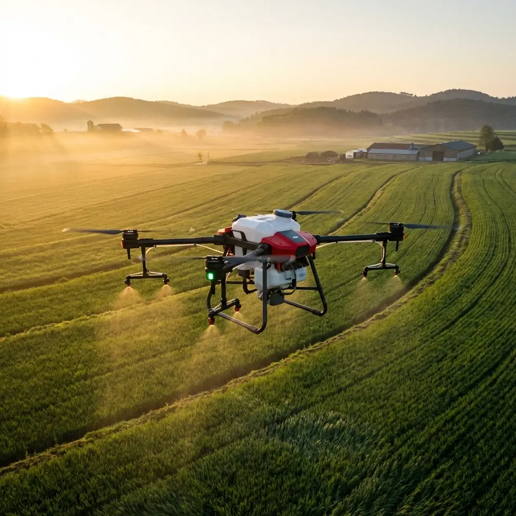
Agras T70P in Dusty Field Wildlife Checks: A Practical Workflow That Saves Time and Reduces Risk
META: A field-tested guide to using the Agras T70P for dusty wildlife inspection work, with practical lessons on low-altitude imaging, RTK precision, safety tradeoffs, and data workflow.
Dust changes everything.
It softens contrast, clogs surfaces, hides wires, flattens terrain cues, and turns a simple wildlife inspection flight into a judgment call. I learned that the hard way during a dry-season habitat survey on mixed agricultural land, where we were trying to confirm animal movement near irrigation edges and remnant vegetation. The aircraft could fly. The challenge was deciding how low, how slow, and how much detail was actually worth chasing.
That is where the Agras T70P becomes interesting—not because it magically removes field complexity, but because it fits into a smarter operating logic. If you are inspecting wildlife in dusty conditions, the real advantage is not brute capability alone. It is how you combine precision, survivability, and disciplined image collection so you get usable evidence without wasting batteries, time, or margin for safety.
This article lays out that workflow.
The first mistake: assuming lower altitude always means better inspection
People often think the answer to wildlife inspection is simple: fly lower and capture more detail. On paper, that sounds sensible. In the field, especially in dusty terrain, it can be the most expensive mistake of the day.
One reference case from an ArcGIS integrated field-collection workflow makes the tradeoff plain. In that example, high-definition orthomosaic capture was performed at about 100 meters, while sample-point collection required flight at roughly 15 meters. The lower flight produced finer visual detail, but each image covered much less ground. That forced the aircraft to fly slower and collect more photos to cover the same area. The result was heavy growth in battery consumption, more flight time, and longer processing time back in the office.
That matters directly for wildlife checks with the Agras T70P in dusty environments.
If your goal is to identify habitat disturbance, animal tracks near water access, burrow zones, or edge-use patterns across broad farmland, you should not begin by dropping to ultra-low altitude across the whole mission. Start with a wider-area pass, then reserve lower-altitude inspection for selected targets. Dust further strengthens this logic because low-level operations in uneven terrain give you less reaction time and a dirtier visual feed.
The same ArcGIS source also warns that in some survey areas, terrain variation can reach dozens of meters, making automatic low-altitude flight vulnerable to collisions with hillsides, trees, or wires. Anyone who has flown around field boundaries in dry conditions knows how real that risk is. Dust haze reduces depth perception. Thin utility lines disappear. Scrub and raised vegetation can present late.
So the first operational rule for the T70P is simple:
Use broad reconnaissance first. Use close inspection selectively.
That sounds ordinary, but it is the difference between a productive day and a dangerous one.
Why RTK discipline matters more than raw image volume
The second mistake is trying to solve every uncertainty by collecting more footage.
A better answer is better positioning.
One of the most useful points in the Esri drone solution material is the emphasis on drone and GIS integration, especially where RTK-supported workflows are tied to operational decision-making. The slide set references RTK and a mapping benchmark of 1 square kilometer at 1:500, which points to a broader truth: when your positional confidence is high, each image and each observation becomes more useful.
For wildlife inspection with the Agras T70P, a strong RTK fix rate is not just a mapping luxury. It directly improves repeatability.
If dust, vegetation, or seasonal use patterns require you to revisit the same corridor several times, centimeter-level consistency helps you compare what changed and what did not. Did animals shift away from one irrigation bank? Is that disturbed patch newly formed or just better illuminated? Is repeated sign appearing near a fence break or along a drainage seam?
Without precise repeatability, you can spend a lot of time arguing over image interpretation. With stable georeferencing, the conversation becomes much cleaner.
This is also where the T70P earns its place operationally. A machine used in agricultural environments needs to support disciplined route repetition and predictable field performance, not just isolated image capture. In dusty wildlife-adjacent inspections, that means you can mark a suspect area on one sortie and return with confidence to inspect the same spot under improved light or safer wind.
Dust is not only an air-quality problem; it is an interpretation problem
Most operators think of dust as a maintenance issue first. Fair enough. Airborne particulate is rough on exposed surfaces and complicates post-flight cleaning, which is why ruggedness matters and why buyers often look closely at details like IPX6K protection. But dust is equally serious as a data-quality problem.
Wildlife inspection often depends on subtle evidence: narrow movement corridors, slight vegetation flattening, disturbed soil, repeated crossings at field margins. Dust reduces micro-contrast, and that can make a technically sharp image less useful than expected.
This is where I find a surprising parallel in a camera article that breaks down seven scene modes: portrait, landscape, sport, macro, night portrait, handheld night scene, and HDR. The article’s core point is not about consumer photography itself. It is about choosing image logic based on the subject and environment rather than treating every scene the same.
That thinking applies directly to T70P inspection missions.
For example:
- A “landscape” mindset suits the first pass over a broad habitat edge, where you want context and spatial relationship.
- A “macro” mindset fits close inspection of specific ground disturbance, scat zones, burrow entrances, or crop-edge feeding marks.
- An “HDR” mindset becomes useful in dusty light when bright exposed soil sits beside dark shelter vegetation, creating high-contrast scenes that hide detail in one direction or the other.
- A “sport” mindset is relevant when animals may move suddenly and you need to prioritize stable, quickly interpreted capture rather than artistic framing.
I am not suggesting the T70P literally uses those consumer scene modes. The operational lesson is deeper: stop using one capture style for every field question.
When teams fail in wildlife inspection, it is often because they collect imagery uniformly while the environment is not uniform. Dusty corridors, shaded gullies, reflective irrigation channels, and exposed stubble all demand different image assumptions.
A better T70P workflow for dusty wildlife inspection
Here is the field method I recommend.
1. Start with a medium-altitude reconnaissance layer
Do not rush down to leaf-level or track-level inspection. Begin with a broad pass that gives you orientation, access conditions, terrain relief, and obstacle awareness. The ArcGIS case shows why this matters: a flight around 100 meters can efficiently produce a high-definition overview without the extreme battery and photo-volume penalties of very low flight.
For wildlife work, this first layer is where you identify:
- likely movement corridors
- fence gaps
- shade and water interfaces
- vegetation islands
- disturbed patches worth revisiting
- wire and tree hazards that may not be obvious from the ground
In dusty conditions, this altitude also helps you see dust plumes and prevailing movement in the air mass, which can hint at where lower-level image quality may degrade.
2. Build a shortlist instead of inspecting everything closely
One of the most practical insights from the ArcGIS material is that you do not need to collect low-altitude sample points for every plot once a useful reference library exists. The document gives a concrete example: a sample from plot 69 could support interpretation of plots 51 and 52.
That is a powerful idea for T70P wildlife inspection.
You do not need low-altitude confirmation everywhere if several field zones share the same habitat structure, crop stage, soil color, and disturbance pattern. Create a representative reference set. Then apply that interpretation logic across similar neighboring zones.
This reduces unnecessary low-level exposure in dust, saves batteries, and cuts pilot fatigue.
3. Use close passes only where the answer changes a decision
Low-altitude work should be reserved for places where your next action depends on what you see. If a broad pass already confirms no meaningful wildlife activity near a section of field margin, do not descend just because the aircraft can.
Close inspection earns its keep when you need to determine whether:
- a track pattern is fresh or residual
- repeated movement is concentrated at one crossing point
- vegetation disturbance is animal-caused rather than machinery-caused
- a burrow or resting site is active
- crop-edge pressure is localized or spreading
This is where image discipline beats image volume.
4. Monitor obstacle risk continuously through live feed
The ArcGIS source specifically notes that operators collecting low-altitude sample imagery often have to rely on real-time video to check hazards such as terrain, elevated vegetation, and power lines. That is not a minor detail. In dusty wildlife inspection, these hazards become harder to read quickly.
With the T70P, treat the live feed as a risk-management instrument first and an imaging aid second. The moment the feed loses clarity from dust or angle, widen your margin. Wildlife evidence is never worth a wire strike.
5. Treat data handling as part of the flight plan
The Esri presentation makes a larger point that deserves more attention: drone value compounds when data moves into a geographic information workflow, where collection, transfer, processing, and decision support are connected rather than improvised. One slide describes the progression toward automated takeoff, charging, data transfer, and result processing—the idea being that platform intelligence can reduce dependence on constant manual intervention.
Even if your T70P deployment is not fully automated, the principle stands. Wildlife inspection becomes much more useful when each sortie feeds a structured map record rather than a folder of disconnected images.
Label:
- corridor IDs
- water edges
- repeat crossing points
- season and wind conditions
- dust severity
- suspected species indicators
- revisit priority
That is how a drone mission becomes an operational record instead of a memory test.
What the T70P changes in practice
The Agras T70P is often discussed through an agricultural lens, and rightly so. But in dusty wildlife checks around working land, its real value is the way it supports field discipline.
It helps in three ways.
First, it makes route-based repeat inspection more realistic. If you are tracking recurring wildlife activity near field boundaries, repeatable paths and strong position confidence matter more than one spectacular close-up.
Second, it supports work in the same rough environments where agricultural operators already spend their time. Dust is not an exception in those places. It is the baseline.
Third, it encourages an operational style that combines broad-area coverage with selected close investigation, which is exactly what the ArcGIS case recommends in another context. The lesson transfers cleanly: collect enough detail to interpret, but not so much that the mission collapses under battery drain, processing load, or safety risk.
A note on calibration and false confidence
Because the T70P lives in the orbit of agricultural operations, users often think in terms like swath width, nozzle calibration, and spray drift. Even when you are not spraying, that mindset can be useful. Why? Because it teaches respect for environmental variables.
Spray drift awareness trains operators to read crosswinds and boundary effects. That same habit helps during wildlife inspection in dust, where fine airborne material can distort your visual confidence and alter how close you should fly to a target edge. Calibration thinking also matters: if your sensors, camera settings, or route spacing are inconsistent, your interpretation quality will drift even if your aircraft performance is stable.
The danger in dusty inspections is not usually obvious failure. It is false confidence built on poor visual conditions.
The simplest lesson from my own field experience
The turning point for me was giving up the idea that every wildlife question deserved a low flight.
Once we shifted to a layered method—overview first, target list second, close inspection only where needed—our battery use dropped, hazard exposure improved, and the office received fewer but better images. The team spent less time sorting redundant files and more time interpreting movement patterns that actually mattered.
If you are using the Agras T70P in dusty wildlife-adjacent environments, that is the habit worth building.
Not lower by default. Smarter by default.
And if you are comparing workflows or want to sanity-check a field setup, you can message a T70P workflow specialist here and discuss route planning, positioning, and image collection logic before the next deployment.
Final checklist before launch
For a dusty wildlife inspection sortie with the T70P, I would verify:
- RTK status and expected fix stability
- terrain variation across the route
- likely wire crossings and elevated vegetation
- whether a medium-altitude overview can answer most questions
- which zones truly justify low-altitude inspection
- whether representative sample areas can stand in for neighboring zones
- post-flight GIS labeling plan
- cleaning and protection steps after landing in dusty conditions
That last point matters because dusty environments rarely punish you all at once. They degrade reliability over time.
A well-run T70P wildlife inspection mission is not about chasing the closest possible image. It is about balancing detail, repeatability, and safety so each flight adds trustworthy evidence to the map.
Ready for your own Agras T70P? Contact our team for expert consultation.