Agras T70P for High-Altitude Vineyard Inspection
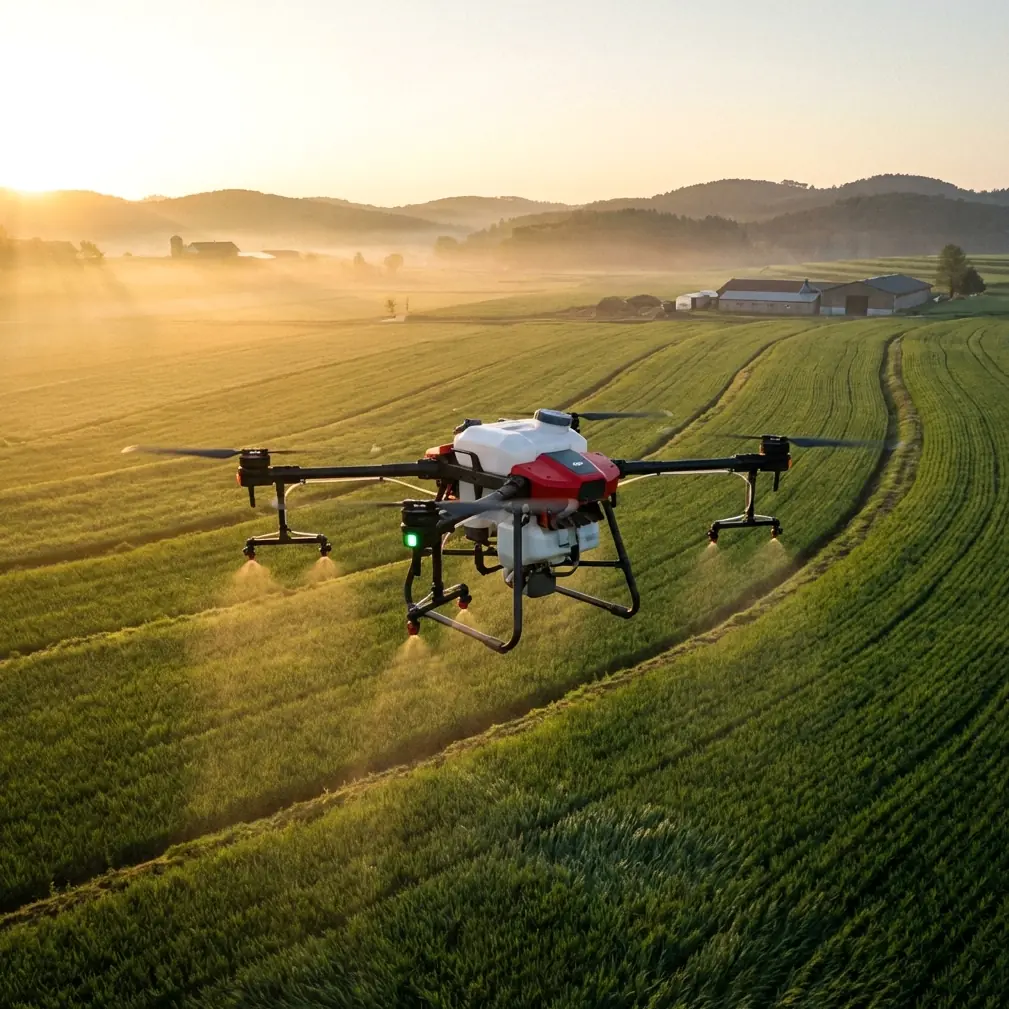
Agras T70P for High-Altitude Vineyard Inspection: A Practical Flight Workflow That Starts Before Power-On
META: A field-focused tutorial on using the Agras T70P for high-altitude vineyard inspection, with practical guidance on pre-flight cleaning, RTK stability, spray drift control, nozzle calibration, and terrain-sensitive mission planning.
High-altitude vineyards ask more from a UAV than flat-row farms ever will. Air density changes. Wind behavior gets less predictable. Slopes distort spacing, visual judgment, and coverage assumptions. Add narrow terraces, fragmented blocks, and the need to document plant stress without disturbing the canopy, and the margin for error shrinks fast.
That is exactly why the Agras T70P deserves a more operational discussion than the usual feature summary. For vineyard managers, drone pilots, and technical teams working at elevation, this aircraft is not simply a platform that lifts payload and follows waylines. Its value shows up when the workflow is disciplined enough to preserve accuracy on uneven terrain, maintain stable positioning, and keep fluid systems clean enough to behave predictably when every row edge matters.
This tutorial is written for a very specific use case: inspecting vineyards in high altitude, where you may be alternating between visual crop assessment, terrain-aware route planning, spot treatment decisions, and data capture that supports agronomic judgment. The goal is not to repeat a brochure. It is to help you use the Agras T70P in a way that reduces avoidable error.
Why high-altitude vineyard work changes the way you set up the T70P
A vineyard on a mountain shoulder or elevated plateau introduces three immediate operational constraints.
First, wind is rarely uniform. A weather reading taken from a takeoff point does not tell the full story once the aircraft crosses a retaining wall, ridge break, or narrow corridor between blocks. Even a small lateral push can affect swath placement and increase spray drift risk, especially near vine edges and access roads.
Second, terrain compresses and expands your perception of distance. On steep gradients, a route that looks evenly spaced from the ground may produce inconsistent coverage if the aircraft is not continuously accounting for height relative to the canopy and ground profile.
Third, GNSS performance can become deceptively variable. Open sky usually helps, but mountain relief, nearby structures, and steep-sided rows can still affect the consistency of your RTK Fix rate. In a vineyard, centimeter precision is not a luxury metric. It determines whether repeated passes line up cleanly enough to avoid overlap, misses, and unnecessary canopy wetting.
The T70P becomes especially relevant here because this class of agricultural aircraft is built for precise route execution, repeatable coverage, and harsh field conditions. But none of that matters if the operator treats setup as routine. High-altitude work punishes lazy preparation.
Start with the least glamorous step: clean the aircraft before inspection work
Before batteries, route files, or payload decisions, begin with a cleaning check. Not a quick wipe. A targeted pre-flight cleaning step.
This matters for two reasons. The first is safety. The second is data quality.
If the aircraft has previously been used for spraying, even trace chemical residue around the spray system, pump area, nozzle mounts, landing gear, vision-related surfaces, and body seams can create problems during an inspection mission. Dried residue can interfere with moving parts, affect sensor clarity, and introduce contamination risk when the drone operates close to foliage you are trying to evaluate.
The T70P’s field-ready sealing standard is part of the reason crews trust this category of machine in demanding environments. An IPX6K-rated airframe is designed to tolerate rigorous washdown conditions better than lightly protected UAVs. Operationally, that is significant because vineyard dust, sticky residues, and fine particulate matter accumulate quickly at elevation, especially in dry periods. A machine that can be cleaned thoroughly is easier to return to a known baseline before each mission.
But do not confuse water resistance with permission to be careless. The point of the cleaning step is precision, not force. Focus on nozzle assemblies, spray lines, arm joints, landing surfaces, obstacle-sensing windows if equipped in your configuration, camera or imaging surfaces, and any area where residue can harden. If you skip this, you risk two very practical failures: compromised safety features and compromised observations.
In vineyard inspection, the aircraft is often flown lower and closer than in broadacre work. If a vision or sensing surface is obscured, the operator may not realize the system is working with degraded input until the aircraft is already in a tight corridor. That is a poor time to learn that “mostly clean” was not clean enough.
Separate inspection logic from spray logic, even on the same day
Many vineyard operators use one aircraft ecosystem for both crop assessment and treatment planning. That makes economic sense. It can also create procedural sloppiness.
Inspection flights and spray flights should be treated as distinct mission types, with different success criteria.
For inspection, you are trying to reveal variability: weak vigor zones, irrigation asymmetry, drainage effects, disease patterns, heat stress signatures, and canopy gaps. If you are working with multispectral data in your broader workflow, the flight needs to prioritize consistent altitude, stable overlap, and clean georeferencing rather than treatment throughput. In practical terms, that means slower, more deliberate route execution and careful attention to positioning quality before launch.
For spray operations or calibration runs, the focus shifts toward deposition behavior, drift control, and application uniformity. This is where nozzle calibration and swath width discipline become central.
The mistake I see most often is pilots carrying spray assumptions into inspection missions. They fly too fast, build routes too wide, and accept positioning quality that would be tolerated in a rough application pass but not in a mapping or close visual evaluation task. In steep vineyards, that difference shows up immediately in the usefulness of the output.
RTK Fix rate is not a dashboard ornament
If you only monitor one technical parameter before a high-altitude vineyard mission, make it the RTK Fix rate.
A stable fix is what turns a good agricultural UAV into a repeatable measurement tool. Without it, you can still fly. You just lose the confidence that each path, waypoint, or row-edge reference truly matches the intended line on the ground.
In vineyards, that loss compounds. Narrow row geometry means lateral error has visible consequences. If you return later to inspect the same rows after irrigation changes, canopy management, or a spot treatment, inconsistent positioning makes before-and-after comparison less trustworthy.
Centimeter precision is especially useful on sloped parcels where human visual estimates of track spacing are misleading. The aircraft may appear aligned from the operator’s perspective while actually drifting enough to distort the inspection pattern. When RTK quality is strong, row-to-row repeatability improves, and that improves everything built on top of it: image alignment, route consistency, and the confidence to revisit small problem zones.
A practical rule: do not rush launch because the weather window feels narrow. In mountain vineyards, a hurried takeoff with unstable positioning often wastes more time than a short delay to confirm a solid fix. If your signal quality is inconsistent, move the base setup if applicable, reassess interference sources, and confirm that the planned route does not force the aircraft into terrain positions that degrade the solution.
Build the route around terrain, not around the map screenshot
One of the odd traps in vineyard UAV planning is trusting the neatness of the software view more than the physical reality of the slope.
On paper, the rows look orderly. In the field, terraces bend, gaps interrupt the planting pattern, and elevation changes alter how the aircraft interacts with both the canopy and the wind. The T70P should be flown with terrain sensitivity in mind from the start, not corrected mid-mission after the operator notices inconsistent stand-off distance.
Swath width is the first place to be conservative. At elevation, operators are often tempted to maintain broad spacing for efficiency. That works until crosswind variation and uneven ground begin creating edge inconsistency. A slightly narrower planned swath often produces more reliable inspection coverage because it lowers the penalty of minor lateral drift and terrain-induced height variation.
This becomes even more important if the inspection flight is meant to support later treatment decisions. If your route leaves uncertainty about where canopy stress begins and ends, the downstream prescription becomes less precise. In other words, route geometry is not just a flying issue. It is an agronomic decision.
Nozzle calibration still matters during inspection days
Some crews assume nozzle calibration can wait if the day’s primary objective is inspection. That is risky when the aircraft may shift from observation to spot intervention, trial application, or flow verification.
At high altitude, environmental conditions can make spray behavior less forgiving. Fine droplets are more vulnerable to drift, and slope-driven airflow can carry them farther than expected. If nozzles are partially obstructed, worn, or not matched in output, the result is not merely uneven application. It becomes a false agronomic signal. A pilot may think a treatment underperformed when the real issue was delivery inconsistency.
This is why calibration deserves a place even in an inspection-centered workflow. Check for uniformity, confirm there is no residue-induced distortion in the spray pattern, and verify that each nozzle behaves as intended. The operational significance is straightforward: good calibration protects both treatment accuracy and the integrity of any conclusions you draw from what happens afterward.
In vineyard blocks where row spacing changes slightly across the slope, poor nozzle performance can mask whether the problem is route design, environmental drift, or hardware inconsistency. Calibration removes one variable from that equation.
Spray drift control starts before liquid leaves the tank
Spray drift is often discussed as if it begins at the nozzle. In reality, it begins with planning.
In high-altitude vineyards, drift risk is shaped by topography, canopy porosity, slope exposure, and shifting wind fields. Even when the T70P is not performing a full application mission, any test spray, spot treatment, or calibration verification should be planned with drift as a first-order concern.
Here the relationship between nozzle choice, droplet behavior, aircraft speed, and swath width becomes decisive. If wind is channeling upslope through a narrow block, a technically acceptable setting on flat ground may become irresponsible on the hillside. The aircraft may remain perfectly controllable while the droplets do not.
Operationally, that means you should define your no-fly and no-spray zones before takeoff. Identify row ends that border roads, neighboring parcels, worker access paths, or exposed edge vines. Then make route decisions accordingly. Precision in the air is only valuable if the resulting deposition stays where it should.
Use inspection output to ask narrower questions
The best T70P vineyard missions do not try to answer everything at once. They reduce uncertainty in stages.
A useful high-altitude inspection sequence often looks like this:
Start with a broad pass to identify anomalies in vigor or canopy density. Then review where slope position, irrigation layout, and sun exposure overlap with the anomalies. If your operation incorporates multispectral analysis, use that layer to separate apparent stress from structurally thinner canopy areas. Then return with a tighter mission or ground inspection to confirm whether the issue is nutritional, hydraulic, pathological, or simply developmental variation.
That progression matters because mountain vineyards regularly produce patterns that look alarming from above but are perfectly logical on the ground. The drone helps you narrow the question. It does not eliminate the need for agronomic interpretation.
If your team needs a cleaner field protocol for that handoff between UAV data and on-site scouting, I recommend sharing one standard checklist through our vineyard UAV field support channel. Keep it technical and short enough that crews will actually use it.
A practical pre-flight sequence for the Agras T70P in vineyard elevation work
For teams that want a repeatable habit rather than a theory, this is the sequence I teach:
- Clean the aircraft thoroughly, with special attention to spray hardware, sensor-facing surfaces, landing gear, and any dried residue near critical components.
- Inspect nozzle condition and confirm calibration status, even if the mission is inspection-led.
- Verify battery condition and environmental suitability for the altitude and temperature range on site.
- Confirm RTK Fix rate stability before launch and do not accept marginal positioning simply to save a few minutes.
- Review terrain-relative route logic rather than relying only on the planning screen.
- Reduce swath width where slope, wind, or row irregularity increases uncertainty.
- Identify likely drift corridors and block-edge sensitivity before any spray-related task.
- Use the first pass to validate assumptions, not to maximize area covered.
None of this is flashy. All of it improves mission quality.
What makes the T70P genuinely useful here
The Agras T70P is most useful in high-altitude vineyard inspection when it is treated as a precision field instrument rather than a generic farm drone. Two details illustrate why.
The first is its ability to operate within a precision-oriented workflow where RTK-backed positioning supports centimeter-level repeatability. In vineyards, that directly affects row alignment, revisit accuracy, and confidence in comparing conditions across time.
The second is the practical durability implied by an IPX6K-rated design. In real agricultural use, a UAV that can be cleaned properly after residue, dust, and wet field exposure is easier to maintain in a reliable state. That matters not because ruggedness sounds impressive, but because dirty aircraft produce degraded sensing, less trustworthy flights, and more avoidable maintenance interruptions.
For high-altitude operators, those are not side notes. They are the difference between a drone that occasionally helps and one that becomes part of a disciplined vineyard management system.
The strongest T70P flights I have seen were never the fastest. They were the most deliberate. Clean airframe. Stable RTK. Conservative swath decisions. Calibrated nozzles. Terrain-aware routing. Clear separation between inspection goals and treatment goals.
That is how you get useful output from a demanding site.
Ready for your own Agras T70P? Contact our team for expert consultation.