
Agras T70P for Coastline Work: A Field Tutorial
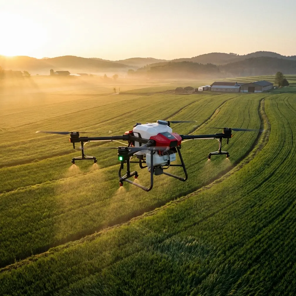
Agras T70P for Coastline Work: A Field Tutorial from an Operator’s Perspective
META: Practical expert tutorial on using the Agras T70P in complex coastal terrain, with airspace, weather, visibility, and drift planning insights for safer, more precise UAV operations.
Coastline work looks simple on a map. In reality, it is one of the more unforgiving environments you can hand to a drone team.
You have wind shear coming off water, uneven terrain that changes visual reference from one pass to the next, salt-laden air, and access points that often force awkward takeoff and landing choices. Add the need to maintain precise route control near vegetation edges, embankments, seawalls, drainage lines, or aquaculture zones, and the margin for error narrows fast.
That is where I started to appreciate what a platform like the Agras T70P changes operationally. Not in an abstract spec-sheet sense. In the day-to-day sense. The kind that shows up when a job that used to require repeated pauses, conservative spacing, and constant weather second-guessing becomes structured, repeatable, and easier to defend from a risk-management standpoint.
This guide is built around that reality: inspecting and servicing complex coastal areas with the Agras T70P, while tying the workflow back to two things that matter more than most operators admit—airspace access and weather discipline.
Why coastline missions are different
A coastal mission punishes sloppy assumptions.
On inland sites, crews often get away with rough visual judgments about wind and visibility. Along a shoreline, that habit can produce drift, uneven application, poor edge tracking, and aborted runs. Even when the aircraft is capable, the environment can quietly degrade results before the pilot notices.
For an Agras operator, this matters in several ways:
- spray drift risk rises near open water and exposed banks
- nozzle calibration becomes more consequential because crosswinds exaggerate uneven deposition
- RTK Fix rate stability matters more when terrain and shoreline geometry create narrow working corridors
- swath width decisions that look efficient on paper may be too aggressive in gusty edge zones
- visibility limitations can turn a manageable route into a poor operational choice
The T70P conversation, then, should not start with payload bragging. It should start with control.
The overlooked operational shift: more usable airspace means better planning
One of the most practical recent developments for drone operators came out of Guangxi, where a new version of designated drone-suitable airspace has been put into use to accelerate low-altitude economic activity. That may sound like a policy story for airshow planners, but it has direct relevance to serious commercial users.
A local drone formation planner, Li Jie, noted that long approval cycles previously limited large drone activities to scattered holiday events and fixed locations. With the expanded suitable airspace, operations are expected to happen more frequently and across more sites.
Why does that matter to someone running an Agras T70P on coastal terrain?
Because access friction shapes mission quality.
When airspace options are constrained, operators tend to compress work into narrower time windows, suboptimal launch points, or less ideal weather periods. When suitable operating zones expand, teams can choose better staging areas, reduce unnecessary repositioning, and fly when field conditions align with agronomic or inspection priorities rather than just administrative convenience.
For T70P crews, that translates into three tangible advantages:
1. Better launch placement
In coastal terrain, takeoff position can determine whether the first leg starts in clean air or in a turbulent zone near a ridge, rock line, or seawall. More available operating space gives the team room to choose a safer and more efficient start point.
2. Less pressure to force the mission
If approvals or available sites are too restrictive, crews often feel pressure to “just get it done” in marginal weather. Expanded suitable airspace reduces that temptation. That alone can improve consistency more than any single hardware feature.
3. More repeatable site coverage
High-frequency, multi-site operations are not just for drone shows. The same principle helps coastline inspection and treatment programs by making recurring visits practical. That matters when monitoring erosion-prone edges, vegetation health, drainage obstructions, or saline intrusion patterns over time.
For a T70P operator, the strategic story is simple: airspace flexibility is an efficiency tool. It gives the aircraft a better chance to perform as intended.
The weather numbers I actually watch before sending a T70P down a shoreline
Coastal operations reward crews who respect ordinary meteorology.
One technical reference in the source material gives a straightforward wind-speed scale measured at 10 meters above ground. It lists conditions from calm to severe, including these useful brackets:
- 12 to 19 km/h: flags extend
- 20 to 28 km/h: dust can be lifted
- 29 to 38 km/h: small trees sway
- 39 to 49 km/h: wires become audible
- 50 to 61 km/h: walking becomes difficult
Those descriptions are more useful than they look. In the field, they let you cross-check instrument readings against what the site is physically telling you.
When I evaluate a T70P mission near a coastline, I am not asking only, “Can the drone fly?” I am asking, “Can it hold mission quality?”
That is a harder question.
My practical reading of those wind bands
12 to 19 km/h can still be workable, but only if the route geometry, nozzle setup, and swath width are chosen conservatively. This is where spray drift begins to become operationally meaningful along exposed edges.
20 to 28 km/h is where many crews start lying to themselves. The aircraft may remain controllable, but dust lifting from the ground is a warning that application uniformity and edge containment may be compromised.
29 to 38 km/h is the point where small trees sway. On a coastline, that usually means the air mass is not just fast, but uneven. Mechanical turbulence near embankments and structures can lead to unstable deposition and route inefficiency. Unless the job is strictly observational and risk controlled, this often becomes a stand-down or delay decision.
Once you get into 39 to 49 km/h, where power lines can be heard, the conversation should be less about productivity and more about whether the mission should proceed at all.
The T70P may be a highly capable platform, but weather discipline is part of professional use. Not an afterthought.
Visibility is not a footnote
The same technical material also gives a visibility scale that is worth using in preflight decisions. It classifies visibility roughly as follows:
- 20 to 30 km: very clear
- 15 to 25 km: good
- 10 to 20 km: average
- 5 to 15 km: poor clarity
- 1 to 10 km: light fog, poor visual conditions
- 0.3 to 1 km: heavy fog, very poor conditions
- less than 0.1 km: dense fog, extremely poor conditions
For coastline work, visibility affects more than pilot comfort. It changes terrain interpretation, obstacle awareness, and route verification.
A shoreline can visually flatten in haze. Breakwaters, utility poles, elevated lines, and wet reflective surfaces all become harder to judge correctly. If visibility drops into that 1 to 10 km bracket associated with light fog, I treat every mission plan more skeptically, especially if the work involves edge tracking, precision application, or repeated turns around irregular features.
This is where centimeter precision and RTK-based route integrity only help if the human decision-making remains disciplined. A strong RTK Fix rate does not excuse poor visibility judgment. Precision navigation and visual situational awareness are partners, not substitutes.
How I structure a T70P coastline mission
Here is the tutorial framework I use when the terrain is broken, windy, and salt-exposed.
Step 1: Split the site into wind zones, not just map zones
A common mistake is dividing the mission by acreage or shoreline length alone. Instead, break the site into:
- exposed waterfront sections
- recessed or sheltered inlets
- elevated banks
- man-made barrier edges
- vegetation transition lines
Each one behaves differently in the same weather window. This matters for spray drift and for choosing an appropriate swath width.
Step 2: Check ground truth against the published wind scale
If the meter says one thing and the environment says another, trust the mismatch enough to investigate.
If flags are fully extended, you are already in the 12 to 19 km/h visual band. If dust is lifting, you are likely in the 20 to 28 km/h range. If small trees are moving consistently, you are likely approaching 29 to 38 km/h. Those are not abstract classroom numbers. They are field cues that affect the T70P’s usable efficiency envelope.
Step 3: Tighten nozzle calibration before the first serious pass
On inland flat plots, operators sometimes get lazy here. On the coast, nozzles that are slightly off-spec can create visible inconsistency because lateral wind influence amplifies small flow differences.
For the T70P, I recommend treating nozzle calibration as part of route planning rather than as a separate maintenance chore. If the mission includes multiple shoreline orientations, recalibrate your assumptions each time the aircraft transitions from sheltered ground to open-water exposure.
Step 4: Reduce ambition on swath width when conditions are mixed
A wide swath width may look efficient during planning. But when one half of the pass runs clean and the other half is exposed to crosswind off water, your “efficient” pass becomes expensive rework.
This is one of the most common hidden losses in coastal drone operations: crews chasing area throughput while quietly sacrificing uniformity.
Step 5: Use RTK discipline for route confidence, not speed vanity
Centimeter precision is most valuable on narrow shoreline bands, drainage edges, and irregular treatment margins. The goal is not to brag about precision; the goal is to avoid overlap, misses, and repeated corrections in awkward terrain.
A healthy RTK Fix rate matters because every manual correction the pilot has to inject under coastal wind stress increases mental load. Once pilot workload rises, mission consistency usually falls.
Step 6: Respect moisture, salt, and cleanup routines
Coastal work is hard on equipment. If your T70P is being used around sea spray, humid embankments, or saline marsh transitions, environmental sealing matters. Terms like IPX6K are not decorative in this context; they speak to whether the platform is realistically suited to repeated exposure to harsh washdown and wet-field conditions.
But sealing is not immunity. Salt is persistent. Post-mission cleaning discipline remains part of fleet reliability.
A real shift in workflow: from “can we squeeze it in?” to “when is the cleanest window?”
Years ago, one of the hardest parts of coastal UAV jobs was not flight execution. It was the stack of compromises before the aircraft even lifted.
We had fewer practical operating windows, less flexibility around site access, and more pressure to accept marginal conditions because the next opportunity was uncertain. That is why the Guangxi airspace story matters more than it first appears. When suitable airspace expands, drone operations stop being isolated events and start behaving more like a dependable service layer.
For Agras T70P teams, that means the conversation can mature.
Instead of rushing into a gusty afternoon because the slot exists, you can wait for a visibility band that stays above the “poor clarity” threshold. Instead of forcing an exposed launch point, you can choose a more stable staging area. Instead of pretending that drift near water is just part of the job, you can design around it.
That is what professionalization looks like in practice.
Where training still matters
One unexpected lesson from the reference set comes from educational drone programming material. It describes RGB LED control with 255 brightness levels per color channel, allowing highly granular visual output, along with programmable display behavior such as scrolling characters and directional changes.
That may seem unrelated to an Agras T70P. It is not.
The larger point is that modern drone work increasingly rewards operators who think in systems, not just stick inputs. Precision, status signaling, sensor interpretation, route logic, and human-machine communication all benefit from structured training. A pilot who understands configurable behaviors and disciplined workflow design adapts better to demanding environments, including coastlines.
That training mindset shows up in the field as cleaner checklists, better interpretation of sensor data, and fewer impulsive decisions when conditions shift.
If your team is refining coastal T70P operations and wants a second set of eyes on workflow design, staging logic, or weather thresholds, you can share the mission profile here: https://wa.me/85255379740
The bottom line for Agras T70P coastline operations
The Agras T70P makes difficult shoreline work easier when you pair it with three things: realistic weather thresholds, disciplined route planning, and better access to suitable airspace.
The reference facts behind this are not glamorous, but they are decisive. Wind at 20 to 28 km/h is already enough to lift dust and challenge clean application. Visibility dropping toward 1 to 10 km should change how confidently you treat obstacle awareness and route verification. And the expansion of drone-suitable airspace in Guangxi signals something bigger than administrative reform: it gives serious operators more room to choose safe, productive mission windows.
That is the kind of advantage that actually shows up in results.
Ready for your own Agras T70P? Contact our team for expert consultation.