Agras T70P in Low Light: A Coastline Inspection Case Study
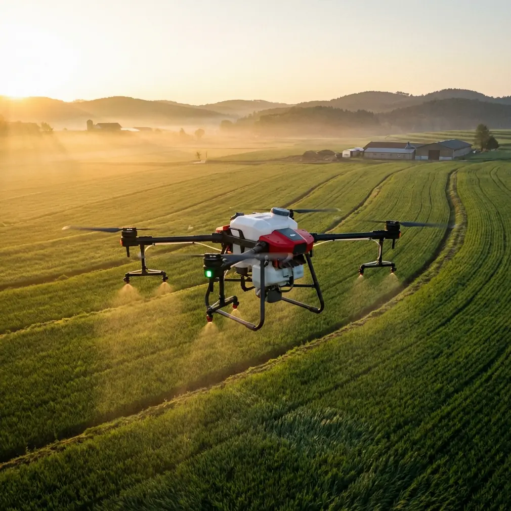
Agras T70P in Low Light: A Coastline Inspection Case Study Through the Lens of “+Drone” Operations
META: A field-based case study on using the Agras T70P for low-light coastline inspection, linking flight control smoothness, operator training logic, RTK precision, and real-world operational decisions.
Most drone articles start with the aircraft. That is usually the wrong starting point.
For a coastline inspection in low light, the real question is not “what can the drone do?” It is “what job needs to be done, and what kind of flying behavior makes that job reliable?” That distinction sounds subtle, but it separates gadget thinking from field operations. Back in July 2018, at the Rebuild2018 technology business summit in Chengdu, one of the recurring ideas around the drone sector was that the industry had moved into a new phase: not “drone+,” but “+drone.” In plain language, the aircraft stops being the center of the story. The mission becomes the center.
That framing fits the Agras T70P unusually well.
I was asked to review a low-light shoreline inspection workflow where the T70P was being evaluated not as a generic unmanned platform, but as a coastal operations tool. The site combined salt air, wind shifts, uneven launch surfaces, and fading visibility. The team’s objective was practical: document erosion edges, standing water patterns near vegetation bands, and access routes for the next morning’s ground crew. This was not a cinematic flight. It was a timing-sensitive information run, done in the half-hour window when daylight was thinning and surface contrast was changing by the minute.
The most revealing part of the operation was not a spec sheet claim. It was how the aircraft behaved during transitions.
Why low-light coastline inspection is really a control problem
Coastline work creates a strange visual environment for pilots and sensors alike. Water reflects residual sky glow. Wet sand can look flatter than it is. Vegetation lines become dark masses. If you are operating near tide pools, embankments, or rock breaks, small control inputs matter more than they do over an open field.
This is where a lot of drone evaluations go shallow. People talk about payloads, spray systems, or swath width as if those numbers alone decide success. They do not. On a shoreline, especially in low light, smooth throttle response and predictable startup behavior can mean the difference between a clean inspection leg and a messy correction at the edge of a dune.
One technical reference that matters here comes from BLHeli Rev12.x. It notes the addition of a programmable main spoolup time, along with changes such as limiting power at very low RPM to avoid sync loss, and making damped light mode smoother and quieter, especially at low and high RPM ranges. Those are ESC-level details, easy to ignore if you only read marketing summaries. In field terms, they speak to a simple operational truth: the aircraft should not lurch into life, hesitate at low rotational speeds, or produce uneven response when the pilot needs precise attitude control near the ground.
For a coastline team launching from compacted sand beside driftwood and rock fragments, that matters. A more controlled spool-up reduces the chance of abrupt dust, grit, or loose debris disturbance at takeoff. Quieter, smoother low-RPM behavior also helps during short repositioning moves when the aircraft is flown conservatively to confirm safe clearance. That kind of refinement is rarely glamorous, but it is the backbone of dependable inspection work.
The wildlife moment that changed the flight plan
About 14 minutes into the mission, the T70P approached a narrow inlet bordered by low brush. In thermal terms, the area was beginning to cool unevenly, which can complicate visual interpretation in low light. As the drone descended slightly for a better look at the embankment edge, movement appeared along the waterline: a heron stepped out from the reeds, followed by two smaller wading birds cutting across the intended inspection corridor.
This was the moment that turned the sortie from routine to instructive.
The pilot did not force the line. Instead, he softened the forward movement, held a safer offset, and adjusted the pass angle to preserve distance while still collecting the needed imagery of the bank. What mattered was not only situational awareness, but the aircraft’s ability to respond in a measured way rather than with abrupt corrections. On paper, that sounds minor. In practice, when animals move unpredictably in dim conditions, smooth deceleration and steady directional control are part of responsible civilian operations.
That is one reason training logic matters as much as hardware.
What an education drone manual unexpectedly teaches about the T70P
One of the more useful references for understanding operational maturity does not come from an industrial white paper at all. It comes from pages 92–93 of a DJI TT educational drone document. The material includes a programming exercise asking what happens if a speed variable, v, starts at a negative value such as -50, and how acceleration logic might be applied to other flight actions or used to design deceleration. It also describes a “thousand-mile message” task where a drone flies out, lands in front of a partner, sends location cues such as “east gate,” “small bridge,” or “pavilion,” waits, then returns.
At first glance, that sounds unrelated to the Agras T70P. It is not.
That educational framework highlights two operational habits that carry directly into serious field use. First, speed is not just magnitude. Direction and rate-of-change matter. If a variable begins at -50, the aircraft behavior changes because the command sign changes the movement logic. For low-light coastline inspection, that same concept appears in the real world every time a pilot transitions from a forward surveying leg into a controlled reverse or lateral correction near an obstacle, waterline, or wildlife exclusion area. Training that treats velocity as a live behavior variable, not a simple on/off setting, produces safer operators.
Second, the “send a message and return” exercise captures something many commercial teams still overlook: a drone mission is often about delivering location-specific information, not just collecting footage. On the coast, that might mean marking a washout near a footpath, identifying a blocked drainage point, or flagging a shoreline access gap for the morning crew. The T70P becomes useful not because it flies, but because it helps the team communicate spatially relevant facts quickly and accurately.
That is the “+drone” idea in action. The mission comes first. The aircraft serves the workflow.
RTK fix rate and centimeter precision are not abstract benefits on the coast
If you are inspecting agricultural blocks inland, slight positional drift can sometimes be tolerated between passes. On a coastline, especially when documenting erosion margins or repeatable inspection tracks, positional consistency is much harder to fake. Readers looking at the T70P often focus on payload or treatment efficiency, but for shoreline documentation, RTK fix rate and centimeter precision deserve more attention.
Why? Because low-light inspection often leaves less room for visual improvisation. When contrast drops, the operator depends more heavily on stable guidance and repeatable path control. A strong RTK solution helps the aircraft hold the intended line relative to berm edges, service tracks, and vegetation boundaries. If the team needs to compare conditions against prior flights, centimeter-level consistency improves confidence that changes in the data are real terrain changes, not path variation.
This also intersects with swath width in a less obvious way. In a treatment context, swath width affects field efficiency. In a coastal inspection context, the concept translates into coverage discipline: how much ground each pass is intended to capture, and how cleanly adjacent passes overlap. If the width estimate and path repeatability are poor, the team either misses narrow shoreline features or wastes time with redundant coverage. Neither is ideal when light is disappearing.
Salt air, moisture, and the practical meaning of IPX6K
Coastal work punishes equipment even when conditions look calm.
Salt mist creeps into everything. Condensation becomes more likely as temperatures fall after sunset. Wind can shift from barely noticeable to annoying in a few minutes. That is why ingress protection is not just a brochure line. For a drone expected to work around marine spray and damp surfaces, an IPX6K-rated protection level has operational significance. It suggests the platform is better aligned with repeated exposure to harsh, wet working environments than aircraft designed around fair-weather assumptions.
That does not make the drone invincible, and it does not remove the need for disciplined maintenance. But it changes the risk conversation. Instead of asking whether the aircraft can survive a pristine demonstration day, the team can ask whether the platform is suited to a schedule that includes splash-prone launch zones, wet air, and post-flight cleaning demands. For commercial operators, that is a far more useful question.
Why spray drift and nozzle calibration still belong in this conversation
Some readers may wonder why spray drift and nozzle calibration would even come up in a coastline inspection case study. They should. The Agras T70P is not being evaluated in a vacuum. It belongs to an agricultural work ecosystem, and that affects how operators think.
A pilot who understands nozzle calibration understands controlled output. A team that respects spray drift understands how wind, direction, and environmental sensitivity affect operations near water, vegetation, and wildlife. Those habits transfer neatly to inspection flying. The same discipline that keeps droplets where they belong also helps keep the aircraft where it belongs. On a coastal route, wind is not just an inconvenience; it is a variable that can shift both safety margins and data quality.
In this mission, the crew’s agricultural background was visible in a good way. They checked the air movement close to the ground, not just at standing height. They watched drift indicators from light debris and grass motion near the dune edge. They adjusted the route accordingly. That mindset is one reason the heron encounter remained uneventful. They were already reading the environment, not simply following a preplanned line.
Low-light sensors are only as useful as the decisions around them
The T70P discussion often pulls readers toward sensor capability, and rightly so. If multispectral data is part of the broader workflow, it can add real value when teams are assessing vegetation health near saline intrusion zones or moisture distribution behind the shoreline. But raw sensing power does not rescue poor mission design.
The better question is when to use what. In low light, a team may rely on visible imagery for terrain context, while scheduling more detailed multispectral work for a better-lit follow-up window. That sequencing matters. A twilight pass can identify where action is needed; a daylight return can capture the richer comparative dataset. The drone is not doing one heroic all-in-one mission. It is supporting a staged inspection logic.
Again, “+drone” beats “drone+.”
The real lesson from this T70P case
The most valuable takeaway from this coastline operation is that the Agras T70P should be judged as part of a complete field system: control smoothness, environmental tolerance, positional reliability, operator training, and mission-specific discipline.
The 2018 industry shift toward “+无人机” was not just a slogan from a conference stage in Chengdu. It was a correct diagnosis of where professional UAV work was heading. The aircraft is no longer the headline act. The job is. When a low-light shoreline mission has to document changing terrain, avoid disturbing wildlife, maintain repeatable positioning, and launch safely from a difficult surface, the right platform is the one that disappears into the operation. It becomes the method, not the spectacle.
That is why the BLHeli-style control refinements matter. Programmable spoolup time and smoother damped response are not nerd trivia; they are part of making the aircraft calm and predictable when the launch site is unforgiving. That is why the educational TT programming exercise matters. Thinking through what happens when speed starts at -50 builds the habit of understanding motion as a dynamic system, which is exactly what a pilot needs when low-light corrections must be deliberate. And that is why RTK fix rate, centimeter precision, IPX6K protection, and environmentally aware route planning belong in the same conversation.
The T70P is most convincing when it is treated not as a flying machine looking for a use case, but as a working tool embedded in a coastal inspection process.
If you are currently building a similar workflow and want to compare route logic, control behavior, or low-light operating assumptions with someone who has done this in the field, you can message Marcus directly here.
Ready for your own Agras T70P? Contact our team for expert consultation.