Filming Vineyard Variability with Agras T70P
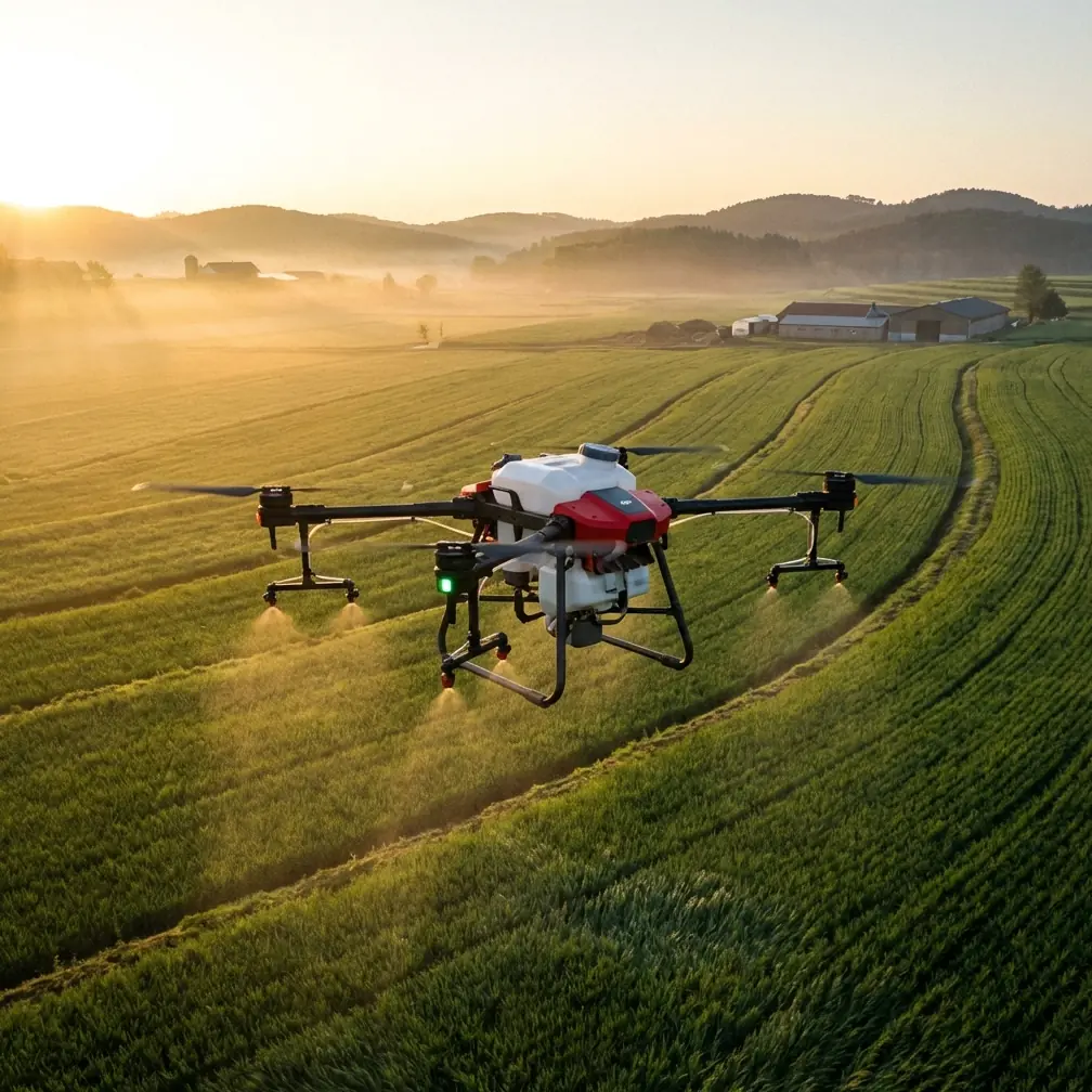
Filming Vineyard Variability with Agras T70P: A Field Method That Holds Up When Dust and Light Change
META: A practical, expert-led guide to using Agras T70P in dusty vineyards for crop imaging, orthomosaic capture, and sample-point documentation with hyperspectral and red-edge insights.
Vineyards rarely give you perfect conditions. Dust hangs in the rows. Light bounces off trellis wire. Leaves tilt, overlap, and hide each other. Then the weather changes halfway through the job and the plan that looked clean on a tablet starts to unravel in the field.
That is exactly why the Agras T70P deserves a more serious conversation than the usual feature summary. For vineyard operators, agronomy teams, and imaging contractors, the real question is not whether the aircraft can fly a route. It is whether the workflow around it can still deliver useful crop intelligence when the environment gets messy.
This article focuses on that practical edge: how to use an Agras T70P workflow for vineyard imaging in dusty conditions, with special attention to orthomosaic generation, sample-point capture, and the agronomic value of visible, near-infrared, and red-edge information.
Why a vineyard imaging job is harder than it looks
Filming or imaging vineyards is not the same as flying over broadacre crops. The canopy geometry is more irregular. Shadows are sharper. Soil visibility changes row by row. Dust contamination can increase during vehicle movement and dry wind gusts. All of that matters because crop spectral response is not isolated from the environment.
One of the most useful facts from the reference material is also one of the least discussed in day-to-day UAV operations: canopy spectral reflectance is easily influenced by leaf water content, canopy geometry, and soil cover. That means a nitrogen or chlorophyll model that looks robust in one block may weaken in another block if the field capture method is sloppy.
This is where the Agras T70P workflow matters. A reliable mission is not only about flight stability. It is about repeatable image geometry, disciplined sample capture, and data sorting that allows post-processing software to do its job without friction.
Start with two different outputs in mind
A lot of failed vineyard imaging projects begin with a single vague objective: “get good aerial footage.” That is not enough if the purpose is agronomic interpretation.
The reference workflow makes a critical distinction between two output types:
- photos used to generate an orthomosaic
- photos used to document interpreted sample points
That split is operationally significant. Orthomosaic images need consistency, overlap, and metadata continuity. Sample-point photos need precision over the target location and a controlled camera angle. Mixing them in one unstructured image pile creates confusion later, especially when processing with orthomosaic software.
A disciplined T70P field routine should mirror this separation from the start. Keep orthomosaic flight imagery in one folder. Put sample-point images in another clearly labeled folder. The source document even specifies a dedicated folder naming approach such as “caiyangdian” for sample points. The naming itself is less important than the habit: separate data by purpose before processing begins.
One more detail from the source should not be ignored: avoid file paths and filenames with Chinese characters or spaces if the downstream software is sensitive to them. It sounds trivial until a processing batch fails late in the day and you lose time rebuilding a project.
The camera angle is not a minor detail
In vineyards, operators often get tempted to improvise at low altitude. That is where avoidable mistakes happen.
The field reference recommends that before reaching the designated plot, the camera should face forward and slightly downward so the pilot can watch for obstacles along the flight line. In vineyard blocks, that matters because wires, poles, edge trees, and service vehicles often sit exactly where a low approach becomes risky. Dust can reduce contrast and make those hazards harder to read on screen.
Once the aircraft reaches the target sample area, the method changes. The camera is switched to a straight-down, 90-degree orientation, and the drone is brought down vertically for the sample photo. The key instruction is even more valuable: do not move horizontally at low altitude during this phase.
That is not just a safety note. It is a data quality note. Low-altitude lateral drift can change viewing geometry, introduce blur, and make point-to-point comparison less reliable. In a vineyard, where each row has a strong directional structure, even small horizontal shifts can change how much leaf, shadow, and soil enters the image. If you are trying to compare vigor or pigment response between sample spots, consistency beats improvisation every time.
Why visible, near-infrared, and red edge still matter in a T70P workflow
Even if your immediate brief is “filming,” agronomy clients increasingly expect usable crop insight from the same mission. That is where the spectral side becomes valuable.
The hyperspectral source material points to a well-established pattern: many nitrogen-sensitive bands are concentrated in the visible region, with strong usefulness near green wavelengths. It also cites work showing that rice canopy hyperspectral data across 400 to 900 nm, with 3 to 5 nm spectral resolution, can estimate leaf nitrogen and chlorophyll. In that study, the reported coefficient of determination reached 0.72 for nitrogen and 0.86 for chlorophyll.
The crop in that example is rice, not grapes, but the operational lesson transfers: visible and near-infrared responses can carry meaningful plant status information when the capture method is tight enough.
For vineyard work with Agras T70P, this means two things.
First, chlorophyll-related interpretation should not be treated as a gimmick. Chlorophyll is central to photosynthesis and crop assimilation, so canopy response in the visible range can support real management decisions, especially when comparing blocks, stress zones, or development stages.
Second, red-edge behavior deserves attention. The reference defines the red edge around the maximum first-derivative spectral response between 660 and 750 nm. That zone is highly useful because it often tracks chlorophyll density better than broad RGB impressions can. In real field terms, if a block looks evenly green to the eye but the red-edge response is shifting, you may be catching physiological differences before they become obvious in standard imagery.
If your T70P setup is paired with multispectral or related sensing workflows, this becomes more than nice-to-have data. It becomes a practical bridge between aerial imaging and crop action.
Dust, mid-flight weather change, and the value of sticking to a method
A dusty vineyard can feel manageable at takeoff and different ten minutes later. I have seen light crosswinds rise enough to push suspended dust back into the rows, flatten contrast near the soil surface, and alter the apparent cleanliness of the canopy in live view. Then a cloud band moves in and the whole tonal balance shifts.
That kind of mid-flight change is where many operators start chasing the image instead of protecting the dataset.
With the Agras T70P, the better move is to preserve the workflow logic:
- complete the orthomosaic sequence cleanly
- return to safe height before repositioning
- capture sample points only in the designated vertical descent mode
- document any environmental shift that may affect interpretation
The source material gives a practical rhythm for this. After each sample capture, the aircraft should rise vertically back to a safe altitude before moving to the next plot. In dusty vineyards, that is especially useful because it reduces low-level lateral movement where visibility, obstacle risk, and contamination effects are all worse.
If weather changes mid-flight, do not blur mission types together just to “finish everything.” Keep map-grade imagery separate from interpretive spot imagery. That separation makes later analysis far more defensible.
Battery planning is part of data quality
One overlooked fact from the reference is battery consumption at the plot level. The field example notes that one battery may be used for automatic orthomosaic collection, while another may be needed for manual sample-point photography. Under skilled operation, two to three batteries of roughly 30 minutes each were enough to complete the fieldwork for one plot.
Why does that matter in a vineyard T70P article?
Because operators who under-budget battery needs start rushing the second half of the mission. That is when they cut corners on camera orientation, sample-point discipline, or folder separation after landing. Battery planning is not just logistics. It protects consistency.
For dusty vineyard imaging, build your plan around separate energy reserves for separate tasks. If conditions deteriorate, you want enough margin to preserve the method rather than compress it.
Orthomosaics are the base layer, not the final answer
The ArcGIS-related reference is direct on this point: a high-definition orthomosaic is the basic data layer for crop recognition. Software such as Drone2Map or ENVI OneButton can process the flight images into this output, reading metadata from the selected image folder automatically.
That metadata step is worth emphasizing. If your T70P capture discipline is solid, the software can ingest the imagery with fewer manual corrections. If your files are mixed, mislabeled, or structurally messy, processing becomes slower and less trustworthy.
In a vineyard, the orthomosaic gives you the structural map of the block: row alignment, missing vines, obvious vigor differences, access conditions, and visible anomalies. But it should be paired with sample-point imagery and, where available, multispectral interpretation. The orthomosaic tells you where to look. Sample points and spectral response help explain why.
A practical T70P vineyard capture sequence
Here is the field-tested logic I would use for a dusty vineyard mission built around the reference methods:
1. Define outputs before takeoff
Decide which images belong to orthomosaic generation and which belong to sample-point interpretation. Treat them as different products from the beginning.
2. Use a forward-downward camera view on approach
Before reaching each designated area, keep the camera aimed forward and slightly down. This improves obstacle awareness in rows, especially where dust and contrast reduction can hide hazards.
3. Build the map layer first
Fly the orthomosaic portion while light is most stable. That becomes your baseline product for the entire block.
4. Switch to vertical sample capture
At each target point, rotate the camera to 90 degrees downward, descend vertically, and capture the image without low-altitude horizontal movement.
5. Recover to safe altitude before repositioning
Do not slide low across vineyard rows. Rise first, then move. It is safer and it preserves the geometry of your sample captures.
6. Log environmental changes
If wind, dust, or cloud cover changes, note the timing. Spectral interpretation is sensitive to more than just plant condition.
7. Organize files immediately after landing
Keep orthomosaic images separate from sample-point images. Check naming and folder structure before importing into processing software.
8. Process with purpose
Use the orthomosaic as the base layer, then overlay sample points and compare them with visible, NIR, red-edge, or chlorophyll-related indicators where your workflow supports that level of analysis.
The hidden link between careful flying and better agronomy
The deeper lesson in the reference data is this: agronomic sensing does not fail only because the model is imperfect. It often fails because field collection is inconsistent.
The hyperspectral research warns that nitrogen diagnosis models can struggle with reliability and broad applicability because reflectance is shaped by time, geometry, moisture, and soil exposure. The field collection workflow answers that challenge in a very practical way: standardize image angle, control aircraft movement near targets, separate mission outputs, and process clean datasets.
That combination is what makes an Agras T70P mission useful in real vineyards. Not hype. Method.
If you are building a workflow for dusty blocks, changing light, and crop interpretation that has to stand up after the flight, this is the standard worth following. And if you want to compare mission design options for your own vineyards, sample capture routine, or multispectral setup, you can send your field scenario directly through this T70P workflow chat.
The strongest UAV operations in vineyards are rarely the most dramatic ones. They are the ones that deliver a clean orthomosaic, reliable sample imagery, and enough spectral discipline to say something meaningful about the crop.
Ready for your own Agras T70P? Contact our team for expert consultation.