Agras T70P Guide for Coastal Forest Work: Precision Setup
Agras T70P Guide for Coastal Forest Work: Precision Setup, Drift Control, and Stable Data Capture
META: A practical Agras T70P tutorial for coastal forest operations, covering spray drift control, nozzle calibration, RTK accuracy, IPX6K durability, and flight planning in humid, wind-prone conditions.
Coastal forests punish weak workflow. Salt in the air, unstable wind layers near the canopy, humidity that lingers on sensors, and narrow operating windows all expose the difference between a drone that merely flies and one that can hold a useful line under pressure. For crews evaluating the Agras T70P for forest-edge documentation, environmental survey support, or precision application near tree cover, that distinction matters more than spec-sheet theater.
I’m approaching this from the perspective of field method, not brochure language. If your mission involves filming forests in coastal conditions, the Agras T70P becomes interesting for a specific reason: it combines the heavy-duty agricultural DNA of a spray platform with positioning and weather resistance traits that can be adapted to demanding forest operations. That does not make it a cinema drone. It does make it a serious aerial tool when the job requires repeatability, payload-oriented stability, and predictable operation in wet, exposed environments.
The first thing to understand is that coastal forest work is not just “flying near trees.” It is flying through moving air shaped by shoreline temperature gradients, canopy turbulence, and reflective moisture. In those conditions, two metrics matter operationally: RTK fix rate and drift behavior. If the aircraft can maintain centimeter precision with a reliable RTK solution, your passes are easier to repeat, waypoint-based corridors stay believable, and overlap for mapping or treatment verification becomes far more consistent. If it cannot, every gust compounds into wasted time and compromised coverage.
That is where the T70P has an edge over lighter multipurpose platforms that promise everything but start to wander once humidity rises and the wind rolls off the water. A heavier agriculture-built aircraft, when properly configured, tends to carry momentum through disturbed air more cleanly. For forest corridors or coastal shelterbelts, that can translate into steadier tracking over a predefined swath width and less correction work from the operator. The advantage is practical rather than glamorous: fewer micro-adjustments, cleaner line fidelity, and better repeat passes when you return to the same stand days later.
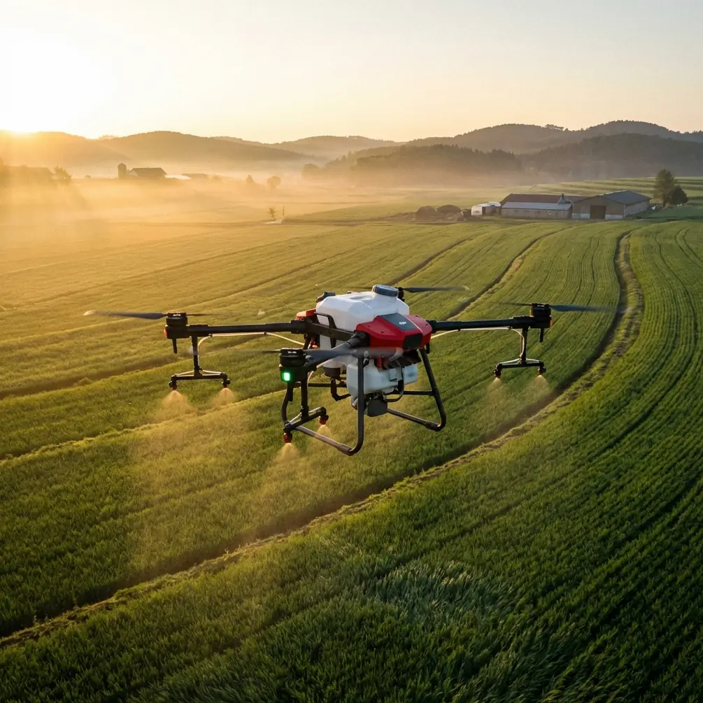
Why the T70P fits coastal forest missions
Most discussions about the Agras line stop at acreage and output. That misses the point for mixed-use operators. In coastal forestry, the value is not simply how much area you can cover. It is whether the aircraft can operate after dawn moisture, continue through a damp salt-laden morning, and still maintain navigational confidence at the edge of dense vegetation.
The T70P’s IPX6K protection rating is one detail that deserves more attention than it usually gets. On paper, that sounds like a durability footnote. In real field work, it affects how confidently you can stage operations around mist, spray residue, and routine washdown. Coastal crews know that exposure is cumulative. Salt crystals, wet debris, and atomized liquid do not need dramatic failure events to cause trouble; they just need repetition. A platform designed for aggressive contamination resistance starts with a real operational advantage over lighter airframes that prefer drier, cleaner conditions.
The second detail is centimeter precision through RTK-assisted positioning. In a coastal forest setting, this has direct consequences for both imaging and treatment-related missions. If you are documenting erosion buffers, tree health patterns, or the margins between managed and unmanaged stands, precision is not academic. It determines whether today’s route actually matches the one you flew last week. If the fix rate drops and the aircraft begins to interpolate more loosely, your visual dataset becomes harder to compare, and your swath alignment suffers. That can distort any attempt to correlate imagery, spray performance, or stand-level intervention outcomes.
Even if your workflow includes multispectral sensing through a separate payload ecosystem, the core aircraft behavior still matters. Multispectral analysis is only as trustworthy as the consistency of the flight path. Coastal forests, with their broken canopy and shifting light, already introduce enough variables. A drone that can hold a corridor with repeatable geometry gives those downstream datasets a stronger foundation.
Start with the coastal variables, not the aircraft menu
Many operators make the same mistake: they begin with settings instead of conditions. For the T70P, the right setup process starts before power-on.
First, evaluate wind behavior at three heights: ground level, mid-trunk, and just above canopy edge. Coastal forest drift is rarely uniform. You may feel a manageable breeze where you stand, while the aircraft encounters lateral push near the top of the tree line. This matters especially if the mission includes spray application, fogging, or any task where droplet behavior is part of the outcome. Spray drift in these environments can become a sideways transport problem rather than a simple downwind one.
Second, define whether your mission priority is visual documentation, treatment accuracy, or terrain-following repeatability. The T70P can support different operational goals, but the tradeoffs must be explicit. A conservative speed profile may improve data consistency in one mission and unnecessarily reduce efficiency in another. There is no universal preset for coastal forest work.
Third, verify GNSS quality and wait for a true RTK-fixed state before committing to corridor work. A degraded fix near trees can tempt operators into “good enough” launches. That shortcut usually reappears later as uneven row spacing, overlap inconsistency, or corrective manual inputs that should never have been necessary.
Nozzle calibration is not optional near forests
If your use case includes application work at forest edges, nozzle calibration deserves as much discipline as flight planning. Coastal conditions amplify every bad assumption about atomization.
The T70P’s usefulness here comes from the fact that it is built around controlled delivery rather than general-purpose hovering. But that strength only shows up when the nozzles are calibrated to the actual liquid behavior you are dealing with. Viscosity, humidity, temperature, and wind structure all influence droplet size and deposition. A nozzle setup that behaved acceptably inland may drift unpredictably when used along a humid coastal tree line.
The practical rule is simple: if you change formulation, pressure behavior, or expected wind exposure, recalibrate. Do not rely on memory. Measure output. Confirm uniformity. Validate droplet pattern against the intended swath width rather than the theoretical one. In forest margins, overestimating swath width is especially costly because the canopy edge creates turbulent recirculation. The aircraft may appear to cover a broad band, while the effective deposition is narrower and less even than expected.
This is one area where heavier agricultural platforms like the T70P often outperform lighter competitors. They are designed around application integrity, not just air-time aesthetics. That means better compatibility with disciplined nozzle tuning, more credible flow management, and a mission profile that treats droplet control as core performance rather than an afterthought.
Filming forests with an agricultural drone: use the right expectations
The prompt here is “filming forests in coastal,” and that phrase needs a professional clarification. If the objective is cinematic footage, the T70P is not the obvious first choice. Its design priorities are endurance, treatment support, and repeatable route execution. But if your “filming” workflow includes documenting forestry operations, capturing progress evidence, surveying hard-to-access shelterbelts, or recording treatment corridors for technical review, then the aircraft’s stability and repeatability become far more valuable than pure gimbal elegance.
That distinction changes how you should fly.
Use the T70P for structured visual capture rather than improvised scenic motion. Plan linear passes along forest margins, establish fixed altitude bands relative to canopy, and rely on repeatable headings for comparison footage. A repeatable path flown with centimeter precision is often more useful for analysts, land managers, and compliance reviewers than a visually dramatic but inconsistent orbit.
When the scene includes reflective water, wet foliage, and moving cloud shadows, repeatability beats artistry. The aircraft that can return to nearly the same line is the one that gives you meaningful before-and-after evidence.
If you need help designing that route structure for your site, a quick field-planning chat via this coastal mission contact channel can be more useful than another hour of trial flights.
RTK fix rate: the hidden variable behind usable results
Operators often talk about RTK as if it were a binary feature: present or absent. In practice, RTK fix rate is a performance pattern. The question is not whether the T70P supports RTK. The question is how consistently it can maintain a fixed solution while skirting tree lines, dealing with partial sky obstruction, and transitioning across reflective coastal surfaces.
In forest-edge operations, a strong fix rate supports three things at once:
- Reliable pass-to-pass spacing
- Cleaner overlap for mapping or multispectral follow-up
- Reduced manual correction under canopy-adjacent turbulence
That last point is easy to underestimate. Every manual correction the operator makes introduces variability. Variability weakens traceability. Once that happens, comparisons across dates, treatments, or stand sections become harder to defend.
A stable RTK workflow also helps you manage risk around narrow buffer zones. In coastal ecosystems, those margins can matter ecologically and operationally. Centimeter precision is not just a nice phrase in that context. It is the difference between confident exclusion and approximate avoidance.
A field-ready coastal setup workflow
For readers who want a practical method, this is the sequence I recommend for Agras T70P deployment near coastal forests:
Begin with environmental mapping. Identify open-sky segments, canopy choke points, and wind-exposed gaps where sea air accelerates inland. Mark areas where salt mist or residual moisture may affect visibility or surface contamination.
Next, establish positioning integrity. Confirm RTK is truly fixed before takeoff and verify that your route logic does not depend on satellite geometry likely to degrade beside dense tree cover.
Then configure application or capture parameters around the real canopy, not the map estimate. Coastal forests often have irregular height transitions. Terrain-following behavior should be checked against actual stand structure, especially where younger growth meets mature tree lines.
After that, calibrate nozzles if your mission includes any liquid delivery. Check pattern uniformity and ensure your planned swath width reflects field-tested behavior under current conditions.
Finally, build in a post-flight rinse and inspection routine. This is where the IPX6K-rated protection becomes operationally relevant again. A platform built for demanding washdown environments gives you more confidence in maintenance discipline, which is exactly what coastal exposure demands.
Where the T70P truly excels against competitors
Many competing UAVs look attractive because they blur categories: part mapping drone, part camera platform, part industrial tool. That flexibility sounds efficient until the weather worsens and the mission requires repeatable low-altitude work near vegetation.
The Agras T70P stands out because it is unapologetically purpose-built. In coastal forest operations, that often translates into three real advantages over lighter, more generalized aircraft:
- Better tolerance for wet, dirty operating environments due to IPX6K-grade protection
- More credible application workflow through nozzle calibration and swath-focused setup
- Stronger route discipline when RTK delivers a stable centimeter-precision fix
Those are not glamorous benefits. They are the sort of advantages professionals notice after the third difficult week in the field, when convenience-based platforms start demanding ideal weather and pristine handling conditions.
The real lesson for coastal forest teams
The T70P should not be treated as a universal answer. It is a specialized aircraft with clear strengths. But for teams working in coastal forests, its strengths happen to line up with the realities that most disrupt field performance: drift, moisture, contamination, and the need to repeat exact paths without wasting time.
If your work depends on holding a reliable line near canopy, managing spray drift at the forest edge, validating nozzle performance instead of assuming it, and preserving data quality through a strong RTK fix rate, the Agras T70P deserves serious attention. Not because it is fashionable, and not because it tries to be everything, but because it is engineered for the kind of disciplined, exposure-heavy work that coastal environments demand.
That is the standard that matters in practice. Not whether a drone looks versatile on launch day, but whether it still produces clean, defensible results after repeated sorties in salt air, damp wind, and broken terrain.
Ready for your own Agras T70P? Contact our team for expert consultation.