Agras T70P in Coastal Field Work: What the Drone Still
Agras T70P in Coastal Field Work: What the Drone Still Can’t See From 3 cm
META: A field-based case study on Agras T70P use in coastal agriculture, focusing on low-altitude crop imaging, sample-point capture, RTK precision, spray workflow decisions, and battery management.
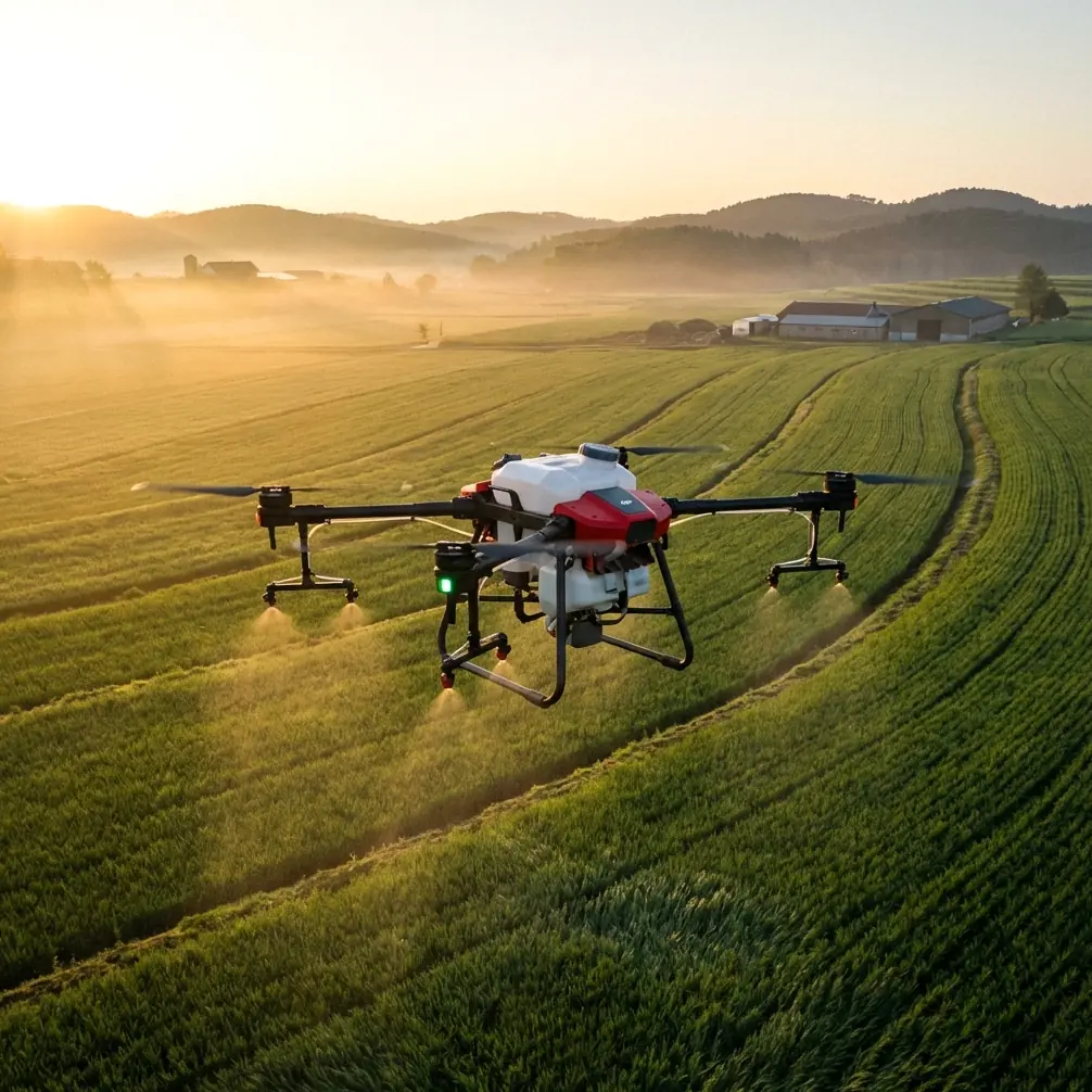
When people outside agriculture think about drones, they usually picture two things: aerial video or tiny delivery aircraft. That framing is already outdated. In real farm operations, especially in difficult coastal plots, a machine like the Agras T70P belongs in a very different category: not a camera toy, but an airborne working robot.
That distinction matters.
Coastal farming creates a strange combination of advantages and penalties for UAV operators. Fields can be open and accessible from the air, but wind exposure, humidity, salt-laden air, fragmented plots, utility lines, embankments, and irregular field edges punish sloppy workflows. If you are using an Agras T70P around these conditions, the real challenge is not simply getting airborne. It is deciding what the aircraft should do at each stage of the job, and what information still requires a closer look.
I have seen this issue come up repeatedly in crop work: operators trust the top-down map too much.
A useful reference from an ArcGIS crop survey workflow makes the point clearly. Even with orthomosaic output at 3 cm resolution, the imagery still could not reliably show crop leaves well enough to identify the exact crop type. At that quality level, analysts could recognize planting density, plant form, and distribution patterns, but not always the species itself. For anyone planning field imaging around the Agras T70P, that is more than a technical footnote. It is an operational warning: high-resolution aerial mapping is excellent for pattern recognition, but not always sufficient for crop verification.
That is the first lesson.
The T70P is strongest when it supports a layered workflow
For coastal field work, the smartest T70P deployments do not treat a single flight output as the whole answer. They combine broad aerial coverage with close-range sample confirmation.
One agricultural UAV survey method described in the source material breaks the process into four stages: image acquisition, production of image and interpretation sample-point data, spatial data management, and final industry application. That framework fits the Agras T70P better than a simple “fly once and decide everything” mindset.
In plain terms, here is what that means in the field:
- First, use aerial passes to establish the full picture of the plot.
- Then, identify areas where the orthomosaic leaves doubt.
- Next, capture low-altitude sample images over those exact spots.
- Finally, connect that ground-truth visual evidence to your mapping and crop decisions.
That is how an aerial robot becomes a practical farm tool.
For coastal operators, this layered method is especially valuable because shoreline conditions often create visual noise. Reflective wet soil, irregular drainage, patchy growth from saline stress, and strong wind effects can all distort what looks obvious from altitude. A top view may show stand uniformity or missing rows, but it may not tell you whether the underlying issue is crop type confusion, disease pressure, salinity stress, or a planting mismatch.
The T70P’s real value appears when you use its precision and stability to narrow those uncertainties instead of pretending they do not exist.
Why low-altitude sample capture still matters
One of the more practical details in the ArcGIS workflow is the so-called “dragonfly touch” method. The aircraft is manually flown at about 40 meters for safe transit, then positioned over the target plot, and only then brought vertically down to roughly 15 to 20 meters to take one or two straight-down sample photos. After that, the aircraft climbs again before moving laterally to the next location.
That is not just elegant. It is smart risk management.
The reason given is brutally practical: low horizontal flight can lead to contact with wires, steep banks, houses, or other obstacles that may sit in the mid-teen meter range. In coastal agricultural zones, this danger is often worse than inland operators expect. You can have drainage channels, utility runs, windbreak edges, fishpond infrastructure, temporary poles, and irregular raised boundaries all inside one operational block.
An Agras T70P pilot who understands this will appreciate the difference between precision and exposure. Flying low is not the problem. Flying low while translating horizontally across uncertain terrain is the problem.
That has direct relevance even if your mission starts as “filming fields.” Good footage and good farm intelligence both improve when the flight architecture is disciplined. If your objective is to document crop condition, demonstrate treatment coverage, or collect visual evidence for agronomy records, vertical dip-and-capture moves are often safer and more repeatable than low sweeping passes between obstacles.
This is also where RTK fix rate starts to matter in a practical sense. In coastal work, where field boundaries can be narrow and actions may need to line up closely with previous treatment records, centimeter-level positioning is not just for pretty maps. It helps the aircraft return to exact sample locations, maintain consistency across repeated visits, and reduce uncertainty when comparing one pass against another. “Centimeter precision” only matters if it improves decisions; in this case, it does.
What the imagery can tell you, and what it can’t
The survey references draw a useful line between broad interpretation and exact identification. Orthographic imagery can reveal:
- crop density patterns
- general plant shape
- field distribution
- boundary logic across parcels
What it may fail to reveal, even at 3 cm, is the detailed leaf-level information needed to distinguish one crop from another in every case.
That gap has consequences for T70P users who are combining imaging with spray or spreading tasks.
If you assume the map alone is enough, you may set the wrong treatment zone, misclassify a mixed parcel, or apply a uniform plan to fields that need differentiated handling. In coastal agriculture, that can cascade quickly. Wind exposure affects spray drift, crop stress may be uneven, and edge effects are stronger near ditches, levees, or shoreline-facing rows. A broad aerial image might show variability; a close sample image explains it.
This is exactly why the older “walk every plot and write notes by hand” method was so labor-intensive. The reference workflow contrasts that traditional ground survey with a UAV-based route that uses targeted aerial acquisition and data production. The point was never to remove human judgment from agriculture. The point was to reposition human judgment so it is used only where the drone cannot yet answer the question alone.
For T70P operators, that is the mature approach.
A coastal case study mindset for the Agras T70P
Let’s put this into a realistic use scenario.
You are working coastal fields with fragmented blocks that were initially outlined from satellite imagery. The source document uses a 200 m × 200 m sample plot as a reference scenario, with field parcels roughly sketched before drone verification. That scale is useful because it reflects how many real crop investigations begin: not with perfect field truth, but with provisional boundaries that need refinement.
Now imagine you launch the T70P to document those plots before treatment planning.
From altitude, you can quickly confirm:
- whether parcel outlines match reality
- whether stand density differs across adjacent blocks
- where wet zones or stressed strips appear
- whether access paths, banks, or structures affect operation planning
But one block remains ambiguous. The canopy pattern suggests a different crop from the adjacent parcel, yet the orthomosaic is not decisive. This is where the T70P should not continue as if the uncertainty does not matter. Bring the aircraft to a safe overhead position, descend vertically into the 15–20 meter band, capture direct sample images, climb out, and move on.
That one disciplined step may prevent a treatment mismatch later.
The same logic carries over into nozzle calibration planning. Calibration is not only about output volume; it is about matching droplet behavior and coverage strategy to actual crop architecture. If the aerial map tells you stand density but the close sample image shows leaf structure, growth stage, or canopy closure more clearly, you have better information for configuring the spray system responsibly. In wind-exposed coastal areas, where drift risk can rise fast, that extra layer of visual confidence is not trivial.
Battery management: the field habit that saves more time than it costs
Here is the battery tip I wish more operators adopted on T70P jobs near the coast.
Do not use your final healthy battery percentage to “squeeze in one more close sample block” after a full treatment or mapping cycle if you know the remaining task involves repeated climbs and descents.
Why? Because the low-altitude sampling method described above is vertical-motion heavy. Climb to safe transit height, descend carefully, hover, capture, climb again, repeat. In real field conditions, especially with coastal wind pressing the aircraft during hover correction, this is not the same load profile as a smooth, efficient route segment.
A battery that looked comfortable at the end of a broad pass can feel suddenly inadequate when you switch to stop-and-drop work.
My field rule is simple: reserve a separate battery plan for sample-point capture and edge-case revisits. That means either:
- assign a fresh pack for the verification phase, or
- set a stricter return threshold before beginning low-altitude confirmation work.
This habit improves more than safety. It improves decision quality. Pilots with battery margin make better judgments around descent speed, framing, hover stability, and obstacle clearance. Pilots trying to finish on a shrinking reserve rush the exact portion of the mission that requires patience.
For teams refining coastal field workflows around the T70P, this is one of the easiest gains to implement.
The Agras T70P should be judged as a system, not a single feature
There is a tendency in drone discussions to isolate one capability at a time: camera quality, payload, weather tolerance, precision, software compatibility. But agricultural value does not appear in isolation. It appears when the aircraft fits a workflow that moves from broad visibility to actionable certainty.
The references behind this article point to that shift very clearly. Drones are no longer just imaging devices. They are becoming operational robots in agriculture, logistics, inspection, and emergency response. In crop work specifically, they support a chain that starts with acquisition and ends with management and application.
For Agras T70P users, especially those operating in coastal fields, the implication is straightforward:
- Use the aircraft for wide-area awareness.
- Respect the limits of orthomosaic interpretation, even at 3 cm.
- Add low-altitude sample capture where crop identity or condition remains uncertain.
- Use vertical descent methods to reduce obstacle risk.
- Treat RTK consistency as a repeatability tool, not just a specification.
- Plan battery usage around mission type, not just flight time.
- Let close visual evidence inform spray setup, drift control, and treatment confidence.
If your team is building a practical T70P workflow for coastal parcels and wants to compare notes on sample-point capture, mapping handoff, or field-safe flight patterns, you can start the conversation here: message Marcus directly on WhatsApp.
The Agras T70P earns its place when it closes the gap between what the map suggests and what the crop is actually telling you. In coastal agriculture, that gap is where the real work lives.
Ready for your own Agras T70P? Contact our team for expert consultation.