Agras T70P for Solar Farms in Complex Terrain
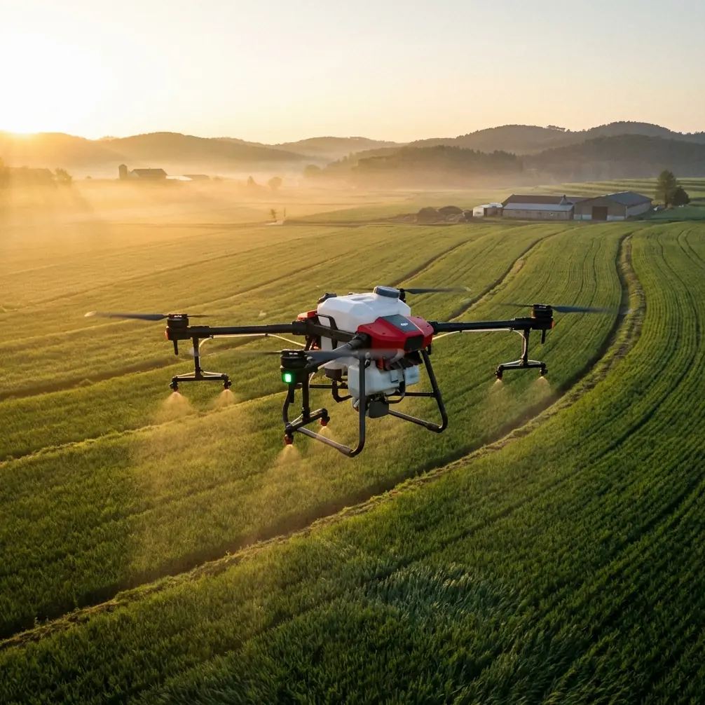
Agras T70P for Solar Farms in Complex Terrain: A Technical Review from an Operations Perspective
META: Expert review of the Agras T70P for solar farm work in complex terrain, with practical analysis of control stability, route accuracy, spray drift, calibration, and why precision matters around hard-to-reach infrastructure.
Solar farms create a strange kind of agricultural problem.
They are not fields in the traditional sense, yet they demand many of the same tools: vegetation control, repeatable coverage, careful route planning, and low-error operations across very large sites. Add embankments, drainage channels, service roads, uneven grades, fencing, and tightly spaced panel rows, and the drone stops being a convenience. It becomes the only practical platform that can work consistently without sending crews into awkward ground conditions.
That is exactly where the Agras T70P becomes interesting.
This is not because “bigger is better” or because every new agricultural platform automatically fits energy infrastructure work. The real question is whether the aircraft can hold precise lateral movement, maintain stable orientation near obstacles, and deliver repeatable application patterns where terrain and access constraints punish weak flight control and poor planning. For solar farm managers, EPC contractors, vegetation maintenance teams, and specialist service providers, those details matter far more than headline specifications alone.
Why solar farms expose weaknesses in agricultural drones
A solar site looks open from above, but operationally it is narrow and unforgiving.
Rows compress usable airspace. Slopes and access roads interrupt regular patterns. Vegetation treatment often needs to happen close to steel structures, inverter pads, culverts, and perimeter lines. In those spaces, swath width is not just a productivity metric. It is a risk variable. Too wide, and you increase off-target deposition. Too narrow, and productivity collapses across utility-scale acreage.
This is where the T70P has to be judged against the practical realities of solar work, not broad-acre crop marketing.
Complex terrain amplifies three performance categories:
- Lateral stability
- Yaw control during line changes and obstacle avoidance
- Positioning precision for repeatable passes
If any one of those slips, you see it immediately in overlap inconsistency, spray drift exposure, missed strips, or over-application around sensitive infrastructure.
The flight-control detail that actually matters in the field
One of the more useful technical references in the source material is not a product brochure at all. It is a training explanation of multirotor motion control, and it gets to the heart of why some heavy-lift aircraft perform more cleanly than others in tight commercial environments.
The document explains that when the flight controller reduces the speed of the two motors on the left side and raises the speed of the two motors on the right side, the aircraft tilts left. If the speed difference remains within a controlled range, the drone achieves lateral movement. If the difference becomes too large and the tilt exceeds 90 degrees, it turns into a roll rather than usable sideward translation.
That sounds basic, but in solar farm work it is operationally significant.
A large application drone moving between panel blocks or tracing edges near service lanes must generate sideward motion without unstable attitude changes. The better the aircraft and control stack manage those motor speed differentials, the cleaner the lateral tracking. For the T70P, this is the kind of behavior operators should care about more than marketing adjectives. Controlled left-right translation is what helps maintain a predictable path when flying offsets along panel rows or compensating for local topography.
The same source also explains yaw in a useful way: if the front-left and rear-right propellers increase clockwise rotational speed while the opposite pair slows correspondingly, total lift can remain unchanged while the airframe rotates counterclockwise from reaction torque. Reverse that relationship and the aircraft rotates clockwise.
Again, this is not just theory. Around solar assets, precise yaw behavior affects how quickly and smoothly the drone can reorient at row ends, align to the next run, or correct heading without inducing unnecessary drift. On sites with irregular block geometry, that translates directly into cleaner turns, fewer heading corrections, and better placement consistency.
In simpler terms: a capable heavy drone is not merely carrying liquid. It is continuously balancing torque, lift, and side-force to stay useful in constrained space. The T70P’s value in solar environments depends heavily on how refined that balance feels under load.
Why route recovery is a bigger deal than most buyers expect
A second reference in the source set comes from aerobatic flight training, which may seem far removed from utility vegetation management. It is not.
The text highlights a principle that applies to all precision flight: before pulling out of a maneuver, the wings must be level. It also notes that a brief pause gives the pilot enough bandwidth to perform accurate corrections, and that a well-executed half Cuban eight can bring the aircraft back closer while restoring speed efficiently, allowing the next maneuver to begin immediately.
For fixed-wing aerobatics, this is about clean transitions. For multirotor solar farm operations, the lesson is route recovery discipline.
At the end of each spray line or inspection segment, the drone has to settle into the next phase of flight with minimal correction debt. If it exits the previous move poorly aligned, every following action becomes an accumulation of compensation. That is where missed margins, uneven overlap, and drift exposure begin.
The operational significance is clear:
- Stable exit attitude reduces correction load on the next line
- Efficient repositioning preserves productivity across long arrays
- Bringing the aircraft back “closer” in a controlled way matters on distant blocks or fragmented terrain
That “closer at the end of the maneuver” detail from the reference is especially relevant on solar farms with separated sections, retention areas, or terrain breaks. Any aircraft that can complete its repositioning cleanly and resume work without a long stabilization delay will outperform alternatives over the course of a full maintenance day, even if the raw top speed difference on paper looks small.
The real benchmark: can the T70P stay accurate where roads and rows fight each other?
Another source detail worth pulling in comes from DJI’s 2025 launch of the Zenmuse L3, described as the company’s first long-range, high-accuracy aerial LiDAR system for collecting data from multiple angles, including roads and hard-to-reach areas.
Even though the L3 is a separate product and aimed at mapping and surveying, the significance for a T70P conversation is strategic. Solar farms in complex terrain are full of “roads and hard-to-reach areas.” That phrase should resonate with anyone maintaining vegetation under and around large PV installations.
Why does it matter here?
Because the best T70P operations are no longer isolated from the broader DJI ecosystem of site intelligence. A modern workflow for solar maintenance can start with accurate aerial data capture over roads, drainage features, embankments, and inaccessible edges, then feed those insights into operational planning for application routes. Multiple-angle data collection matters when terrain creates blind spots or misleading 2D assumptions. It helps teams understand slope transitions, obstruction zones, and access limitations before the spray drone even launches.
This is where the T70P can outperform weaker competitors in practice: not simply through payload or tank design, but through how well it fits into a precision-first workflow built around mapping, route verification, and repeat execution. Many competing platforms can carry product. Fewer fit naturally into an end-to-end operational stack where centimeter precision and planning intelligence reduce rework.
That is the advantage solar operators should pay attention to.
Spray drift is not a side topic on solar sites
On broad-acre fields, drift is often discussed in terms of neighboring crops or weather windows. On solar farms, drift has an added layer: infrastructure sensitivity and compliance expectations.
Mist movement toward panel faces, electrical housings, fencing lines, or adjacent service corridors is not just inefficient. It complicates maintenance standards and can trigger avoidable cleanup or inspection work. That means nozzle calibration on the T70P cannot be treated as a once-and-done setup item. It should be linked to terrain profile, target vegetation density, line spacing, and wind behavior around panel rows.
Panel geometry creates micro-airflow effects. Air can funnel through corridors, spill over array edges, and behave differently near elevated terrain transitions. A drone platform that holds consistent speed and heading through these areas gives operators a much better shot at maintaining intended droplet behavior.
So when evaluating the T70P, I would prioritize:
- nozzle calibration discipline matched to site conditions
- stable ground-relative speed
- reliable line spacing
- consistent height management over uneven sections
- strong RTK Fix rate for repeat passes near constrained boundaries
That last point is critical. A high RTK Fix rate is not a checkbox for marketing decks. On a solar site, it determines whether today’s pass can be reproduced tomorrow with minimal positional ambiguity. When you are treating narrow corridors or working adjacent to assets that should not receive overspray, centimeter precision is the difference between professional-grade maintenance and expensive inconsistency.
IPX6K and environmental durability are more relevant here than many buyers realize
Solar sites are dusty, exposed, and repetitive. Service teams often work in heat, residue, and fine particulate conditions kicked up by vehicles and vegetation management itself. In that setting, a drone with robust ingress protection such as IPX6K carries practical value, not brochure value.
Durability affects uptime. Uptime affects route completion before conditions change. And on terrain-heavy sites, losing a machine to avoidable environmental stress is more than an inconvenience because mobilization across distant blocks is already time-consuming.
A tough airframe also matters when operations span multiple maintenance roles. One week the platform may be focused on targeted vegetation control; another, it may support broader site care workflows that demand repeated transport, setup, and redeployment. Ruggedness is not glamorous, but it is one of the quiet reasons some fleets stay productive longer.
Multispectral thinking, even when the mission is spraying
The context around the T70P often centers on application work, but solar maintenance teams should think a little wider. Multispectral data, whether captured directly in a broader workflow or used as part of pre-job planning, can help distinguish vegetation vigor and moisture variation across a site. That matters because not every section of a solar farm needs identical treatment timing.
In practical terms, better site intelligence can narrow where the T70P needs to fly, reduce unnecessary application volume, and improve scheduling around regrowth risk zones. The drone then becomes part of a decision system, not just a delivery system.
That is another area where the T70P can excel against less integrated alternatives. The best commercial UAV programs are built on feedback loops: map, classify, plan, execute, verify. Solar farms reward that discipline because their terrain and infrastructure layout amplify the cost of guesswork.
What I would look for before deploying the T70P on a complex solar site
I would not start with brochure claims. I would start with a field acceptance checklist:
- Can the aircraft maintain clean lateral tracking alongside panel rows on sloped ground?
- Does yaw correction remain smooth when turning near access roads and fenced boundaries?
- Is the RTK Fix rate stable enough to support repeated centimeter-level corridor work?
- Can nozzle calibration be adjusted quickly for varying vegetation density and drift sensitivity?
- Does the effective swath width stay operationally useful without creating overlap problems near infrastructure?
- Is the platform rugged enough for repeated deployment in dusty, exposed utility environments?
Those are the questions that reveal whether a T70P is simply capable, or actually suited to solar farm production work.
If your operation is modeling route plans, mapping difficult access sections, or building a precision vegetation program around narrow treatment corridors, it is worth discussing site-specific workflows with an experienced team. For direct technical coordination, you can message a UAV specialist here.
Final assessment
The Agras T70P makes the most sense on solar farms when it is evaluated as a precision operations tool rather than a generic agricultural sprayer.
The reference materials point to three ideas that matter more than headline hype. First, controlled motor-speed differentials are the foundation of stable lateral movement and yaw behavior, which directly shape performance in constrained terrain. Second, disciplined maneuver exits and route recovery reduce correction load and keep productivity high across fragmented sites. Third, DJI’s wider push into high-accuracy, multi-angle aerial data collection for roads and hard-to-reach areas signals the kind of ecosystem thinking that solar operators increasingly need.
That combination is what gives the T70P a credible edge.
Not every competing platform handles complex terrain with equal composure. Not every system fits naturally into a workflow built around centimeter precision, drift control, route repeatability, and site intelligence. On utility-scale solar assets, those differences become visible very quickly.
Ready for your own Agras T70P? Contact our team for expert consultation.