Agras T70P Field Report: High-Altitude Solar Farm
Agras T70P Field Report: High-Altitude Solar Farm Operations Without Losing Precision
META: A field-tested Agras T70P guide for high-altitude solar farm work, covering RTK fix stability, antenna positioning, spray drift control, nozzle calibration, and weather-resistant operating practices.
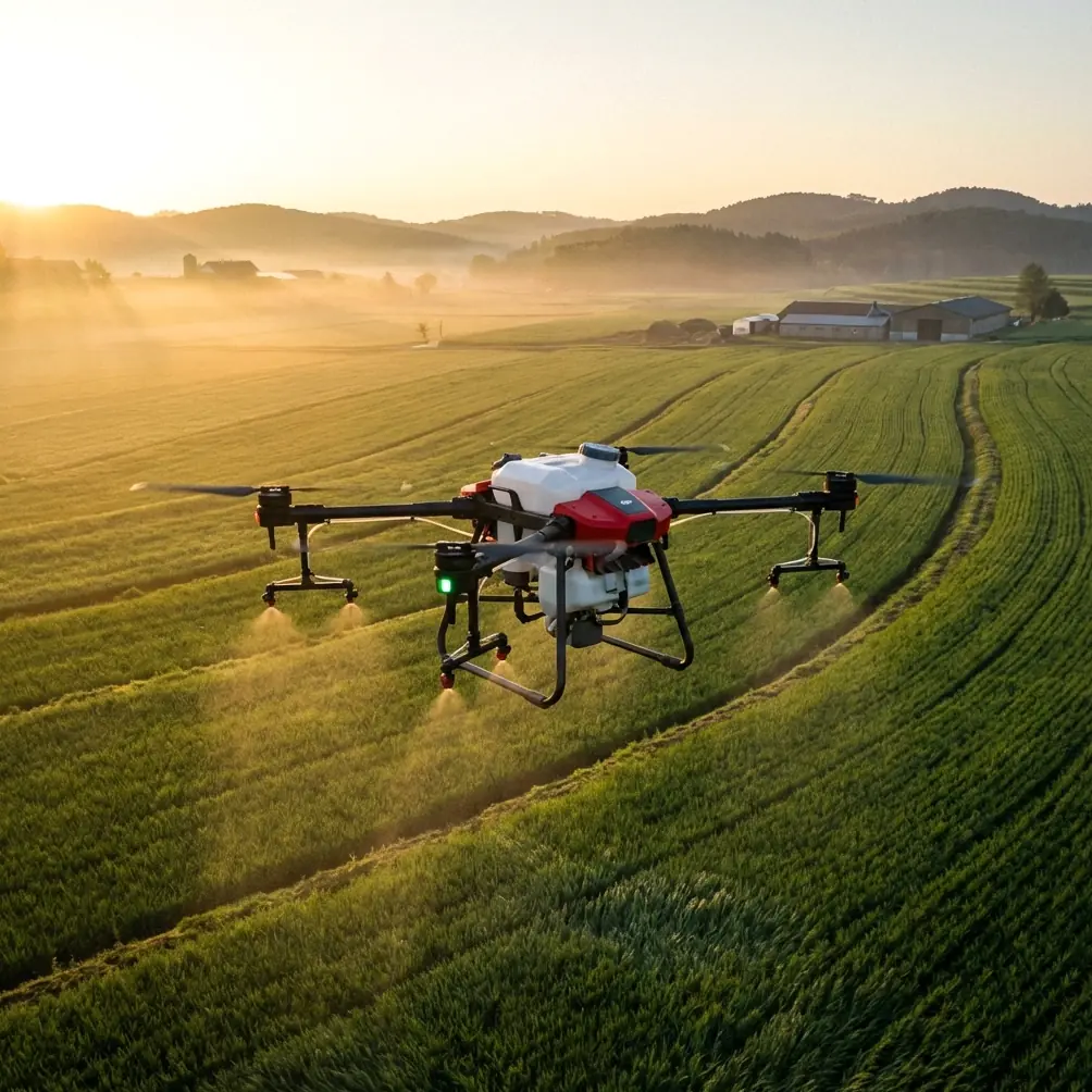
High-altitude solar farms expose every weakness in a UAV workflow. Wind behaves differently over panel rows. Reflected heat distorts local air movement. Long, repetitive corridors tempt operators to prioritize speed over data quality or application accuracy. If your platform is the Agras T70P, those conditions are not a side note. They shape everything from antenna placement to nozzle setup to whether your RTK fix holds when the aircraft moves along metallic infrastructure.
This field report is written for crews working around elevated solar installations where the mission may involve inspection support, vegetation management, or site treatment planning in complex terrain. The T70P sits in an unusual operating space. It is built for serious field productivity, but on solar assets at altitude, productivity only matters if the aircraft remains predictable. That means repeatable positioning, stable links, controlled drift, and disciplined setup before the rotors ever spin.
The first operational truth is simple: high-altitude solar work is a signal-management job before it becomes a flight job. Many crews focus immediately on route geometry, swath width, or payload settings. Those matter. But if your antenna geometry is wrong at takeoff, the rest of the stack starts compromised. On large solar sites, especially those spread across sloped terrain, line-of-sight can look clear while the radio path is actually being disturbed by panel arrays, steel supports, and elevation changes between launch point and work zone.
For the Agras T70P, antenna positioning should be treated as part of mission planning, not as an afterthought. Keep the ground antenna elevated above vehicle roofline and away from metal toolboxes, power inverters, and temporary fencing. On solar sites, a few meters of relocation can materially improve range consistency because you reduce low-angle reflections from panel surfaces. The goal is not just raw signal strength. It is cleaner link behavior as the aircraft transitions across rows and climbs or descends over undulating ground. If the aircraft must work far down a corridor, point the antenna toward the operational center of the mission rather than the far edge. That simple adjustment often improves link stability across the entire flight rather than optimizing only the last segment.
Range problems at solar farms are frequently misdiagnosed as distance problems. They are often geometry problems. I have seen crews launch from the convenient spot next to maintenance infrastructure, only to discover that transformers, service vehicles, and the panel field itself create a cluttered RF environment. A cleaner launch point with better vertical separation typically outperforms a closer but noisier one. If you need help pressure-testing your field setup logic, share site constraints through this practical ops channel: https://wa.me/example
The second issue is positional integrity. Solar farm work rewards centimeter precision because rows are repetitive and visual references can become misleading. The T70P benefits from high-quality RTK workflows, but operators should watch RTK fix rate as a live operational metric rather than a background comfort indicator. A good fix is not merely a green status. It is the foundation for repeatable passes near fragile infrastructure, clean corridor alignment, and consistent return behavior in terrain where elevation shifts can subtly distort pilot perception.
On high-altitude sites, RTK performance can deteriorate for reasons that are easy to overlook. One is base station placement. Another is multipath interference from large reflective surfaces. Solar panels are not passive scenery. They create an environment where signals can bounce in ways that complicate a stable solution, especially when the aircraft operates low over rows and then transitions into open edges or service roads. If your fix rate wobbles during those transitions, resist the urge to push through. Reposition the base, reassess the takeoff point, and confirm that the rover antenna on the aircraft has a clear sky view before the next sortie.
This is where the T70P’s value becomes operational rather than theoretical. When the aircraft maintains centimeter-level positioning, route repeatability improves and your swath width decisions become more defensible. On solar-adjacent vegetation management flights, that matters because overlap errors are rarely obvious in real time. A swath that looks acceptable in open agricultural land may be too aggressive between narrow service corridors or around drainage shoulders near inverter pads. The correct swath width is the one that preserves coverage uniformity without inviting drift or positional creep into sensitive areas.
Spray drift deserves more attention than it usually gets in solar environments. Around panels, drift is not only an efficacy problem. It is a contamination and asset-protection problem. Fine droplets can move unpredictably when rotor wash interacts with thermal currents generated by dark panel surfaces, gravel access lanes, and uneven slopes. High-altitude locations add another layer because thinner air can alter droplet behavior and encourage operators to compensate with settings that unintentionally increase off-target movement.
That is why nozzle calibration on the Agras T70P should be handled as a site-specific task, not a generic preflight checkbox. If the aircraft was calibrated last week on flat cropland, those assumptions may not transfer well to a solar installation perched on elevated terrain. Confirm output consistency, droplet profile, and application symmetry before entering the main field. Small asymmetries become expensive near panel edges, junction boxes, or cable runs. When teams skip this step, they often blame wind for results that were actually created by poor nozzle balance or worn components.
The operational significance is straightforward. Precise nozzle calibration reduces the need to overcorrect with slower speeds or tighter overlap, which in turn preserves mission tempo without sacrificing control. On a site with hundreds of repeating lanes, even a modest calibration error compounds quickly. One imperfect pass is manageable. Fifty imperfect passes turn into a pattern.
Weather resilience also matters more on solar sites than many brochures admit. Dust, irrigation residue, and sudden weather shifts are common, and elevated installations often experience sharper transitions than lower surrounding ground. An airframe with IPX6K-level protection gives crews breathing room when operating in dirty, wet, or washdown-heavy conditions. That does not mean the T70P should be treated carelessly. It means the aircraft is better suited to field realities where equipment is exposed to spray mist, grime, and fast-changing surface moisture.
The practical significance of an IPX6K-rated system is maintenance continuity. After a long day on a solar site, crews can clean the aircraft more confidently and return it to service with less anxiety about every droplet finding its way into a vulnerable point. For operators who move between vegetation control and infrastructure-support tasks, that durability reduces downtime and lowers the temptation to postpone proper cleaning. Deferred cleaning is one of the quiet causes of performance inconsistency in agricultural drones, and solar work tends to accelerate the contamination cycle.
Another factor worth discussing is sensor discipline. Many teams are tempted to bring multispectral workflows into every solar-adjacent mission because more data feels inherently better. Sometimes it is. Sometimes it only adds processing burden. If your mission objective is to map vegetation pressure around panel rows or identify moisture-related growth patterns that affect maintenance access, multispectral data can provide useful separation that standard RGB imagery may not show cleanly. But on high-altitude solar sites, the operator must account for reflected light from panel surfaces and the time window of capture. Poorly timed collection can create noisy datasets that look sophisticated but produce weak operational decisions.
The T70P workflow is strongest when each sensor or mission setting serves a specific question. Are you trying to maintain treatment accuracy around infrastructure? Then prioritize RTK fix stability and repeatable lane geometry. Are you trying to identify vegetation zones that require differential treatment? Then multispectral capture may justify its complexity. Are you simply documenting conditions across a broad hillside array? Then stable flight lines, disciplined overlap, and clean environmental logging may matter more than adding another layer of spectral data.
For pilots, the temptation at high altitude is to overcompensate for uncertainty by flying conservatively in ways that actually degrade output. Excessive height above target can widen the error envelope. Overly narrow swath settings can inflate mission time and battery cycling. Overreliance on manual correction can defeat the value of route precision. The T70P performs best when the operator respects the system enough to configure it properly, then lets it work within a tightly managed envelope.
That envelope starts with antenna placement. It continues with RTK base selection and fix verification. It is protected by nozzle calibration. It is refined through a realistic swath width matched to the site rather than copied from another job. And it is sustained by weather-aware cleaning and inspection routines that take the airframe’s IPX6K durability as a support, not a substitute for discipline.
If I were briefing a university research team or a commercial operations unit before a high-altitude solar mission with the Agras T70P, I would reduce the priorities to five checks.
First, establish the cleanest possible radio environment at launch, even if it means walking farther from site infrastructure. Second, validate RTK performance where the aircraft will actually work, not only at the takeoff point. Third, calibrate nozzles for the site you are on, not the site you remember. Fourth, set swath width based on corridor geometry and drift behavior, not theoretical maximum throughput. Fifth, use sensor payloads only when they answer a real operational question.
These are not glamorous decisions. They are the ones that determine whether your data is trustworthy and whether your application pattern stays where it belongs.
The Agras T70P is not interesting because it is powerful on paper. It becomes interesting when it holds accuracy in a difficult environment full of reflective surfaces, variable winds, and long repetitive lanes where small setup errors become mission-wide defects. High-altitude solar farms expose those errors quickly. They also reward crews who think like system engineers rather than gadget operators.
That is the real lesson from this kind of work. Precision is not one setting. It is a chain. Antenna position affects link quality. Link quality influences confidence. Confidence shapes how aggressively crews plan range and coverage. RTK fix rate governs repeatability. Repeatability determines whether swath width is truly usable. Nozzle calibration decides whether the resulting pass achieves its purpose without drift. Durability standards such as IPX6K keep the platform serviceable between sorties. Every link matters.
For operators planning to use the Agras T70P around elevated solar infrastructure, the smartest move is not chasing maximum output on the first flight. Build a reliable baseline. Confirm your RF geometry. Watch your fix quality. Tune the application system. Then scale. On these sites, disciplined setup is faster than rework.
Ready for your own Agras T70P? Contact our team for expert consultation.