Capturing Remote Highway Corridors with the Agras T70P
Capturing Remote Highway Corridors with the Agras T70P: What Actually Matters in the Field
META: Expert field guide to using the Agras T70P around remote highway corridors, with practical advice on RTK reliability, electromagnetic interference, nozzle calibration, spray drift control, and operational planning.
Remote highway work exposes every weak point in a drone operation.
You are often dealing with long, linear corridors, patchy connectivity, changing winds, reflective surfaces, power infrastructure, and work zones that punish sloppy planning. A platform can look excellent on a spec sheet and still become frustrating once it is asked to perform consistently along dozens of kilometers of road edge, slope, median, drainage line, or adjacent vegetation.
That is why the Agras T70P deserves to be looked at through an operational lens rather than a brochure lens.
For teams using the T70P in remote highway environments, the real question is not whether it can fly a route. The real question is whether it can hold precision where signal quality, interference, terrain variation, and environmental drift all try to pull the mission apart. That is where details like RTK fix rate, nozzle calibration, swath width discipline, and even basic antenna adjustment stop being minor setup items and become the difference between a repeatable job and a wasteful one.
I have seen crews focus on payload and speed first. On remote highway projects, that is backward. Precision and consistency come first. Throughput only matters once the aircraft is producing clean, predictable coverage.
The highway problem is not distance alone
A remote road corridor looks simple from above. It is not.
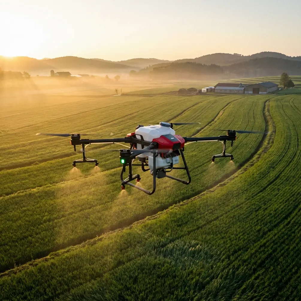
Highways create narrow treatment or survey zones with hard boundaries. One side may be a shoulder and guardrail. The other may drop into drainage, brush, rock, or crop margins. In this type of work, a drone is rarely operating over a neat rectangular field. It is following a ribbon. That geometry changes everything.
Swath width becomes more than an efficiency metric. It becomes a control variable. A wide pass pattern may increase output on open ground, but along a highway edge it can also increase overreach into non-target areas, especially when crosswinds or vehicle-induced turbulence are present. That is where spray drift starts to show up in practical ways. Drift is not an abstract agronomy term here. It is the operational gap between where the material should land and where the environment pushes it.
On the T70P, disciplined swath planning matters because remote corridor work usually asks the aircraft to hold stable application quality over uneven terrain while staying within a narrow operational envelope. If you are treating roadside vegetation, embankments, or drainage margins, there is no benefit in claiming high output if the edge definition is poor.
RTK is only useful when you protect the fix
Centimeter precision sounds impressive, but field teams know the phrase only matters when the fix stays healthy.
For highway-adjacent operations, RTK reliability can be undermined by overhead utility lines, roadside communication infrastructure, metal barriers, bridge approaches, and occasional terrain shadowing. This is where the T70P’s navigation performance should be managed actively rather than assumed. If the RTK fix rate degrades, route accuracy and pass-to-pass consistency can suffer, and on a corridor mission that small error compounds quickly over distance.
The operational significance is straightforward: a weak fix is not just a map problem. It changes overlap, coverage consistency, and potentially the amount of rework required later. One or two bad sections in a corridor can force an entire team back to a site that may be hours away.
That is why I tell crews to monitor RTK behavior before the route begins, not after anomalies appear. Watch how quickly the system acquires and holds lock at the staging point. Then test again after moving closer to likely interference sources. A stable fix near open ground does not guarantee the same behavior beside a steel bridge section or under heavy roadside utility presence.
A simple but overlooked tactic is antenna adjustment. In electromagnetic interference conditions, small changes in ground equipment orientation or placement can improve link stability more than operators expect. If you are working near power infrastructure or roadside comms assets, avoid setting the control point casually beside a vehicle, guardrail cluster, generator, or other reflective or noisy source. Repositioning by even a modest distance can improve signal quality. Elevation and clear line of sight matter. So does orientation. The goal is not magic; it is cleaner signal conditions.
This is one of those unglamorous field habits that saves jobs.
Electromagnetic interference is not rare on road projects
The phrase “remote highway” makes some people think only of isolation. In reality, many remote corridors are threaded with exactly the kind of assets that complicate drone reliability: transmission lines, repeater towers, maintenance depots, instrument stations, and intermittent industrial infrastructure.
The T70P can be a strong platform in these environments, but only if the operator treats electromagnetic interference as a planning input. Do not wait for unstable behavior to start troubleshooting. Build a pre-mission routine around it.
Start by identifying corridor segments likely to produce signal disturbance. Bridge crossings, roadside substations, telecom towers, and dense vehicle staging areas are common trouble spots. Then divide the mission into manageable segments instead of running one overly ambitious route. Segmenting protects data quality and lets you verify positioning integrity before errors propagate down the line.
This is also where the broader UAV software ecosystem is becoming relevant. One recent market signal worth watching came from AirHub, the drone operations software company in The Hague, which closed a €4.4 million Series A round. The practical significance is not the funding headline itself. It is what that level of investment says about where serious operators are putting attention: scalable mission coordination, team management, and tighter control over distributed operations. On remote highway projects, that matters. A capable aircraft like the T70P performs better when supported by strong operational software, clean mission records, and standardized workflows across crews.
AirHub said the capital would be used to scale its international team. That detail matters for field operators because it points to growing support infrastructure around drone fleet management, especially for organizations running multiple sites and long linear assets. When crews are moving between remote corridors, consistency in planning and post-mission review becomes just as valuable as the airframe itself.
Spray drift starts on the ground, not in the air
Operators often blame drift on weather alone. That is incomplete.
Drift control begins before takeoff, with nozzle calibration and route design. If the T70P is being used for roadside vegetation treatment or adjacent land management, nozzle calibration has direct operational significance because it determines droplet behavior, flow consistency, and effective deposition across the intended swath. A poorly calibrated system does not just reduce efficiency. It increases uncertainty. You may end up with sections that are underapplied, sections that receive too much, and edges that become impossible to validate afterward.
On a remote highway mission, that uncertainty is expensive because resupply and return trips are rarely convenient.
Calibrate with the actual mission profile in mind. Do not treat all corridor work as if it were broad-acre spraying. Roadside vegetation often means variable height, abrupt edge transitions, and occasional obstacles that influence airflow. Fine-tuning for one site and carrying that setup unchanged to another is a common mistake.
Swath width should be adjusted to the environment, not to habit. In open stretches with stable wind, a broader pattern may be acceptable. Along embankments, medians, culvert approaches, or sections with lateral airflow, reducing effective swath width can improve deposit uniformity and reduce unintended spread. That tradeoff is usually worth it.
The crews that perform best are rarely the ones pushing the biggest numbers. They are the ones that know exactly why they changed settings, exactly what effect those changes should produce, and exactly how they will verify the outcome.
Remote capture is often a data management problem disguised as a flight problem
When people say they are “capturing highways,” they may mean imaging, documenting vegetation conditions, mapping drainage issues, or monitoring maintenance progress along remote corridors. The T70P discussion often gets narrowed to application work, but field reality is broader. Corridor operations increasingly blend treatment, inspection, and documentation.
That is where related tools such as multispectral workflows can become relevant in the surrounding operation, even if the T70P itself is not the sole data platform on site. For example, if a contractor is evaluating vegetation stress or roadside growth patterns before or after treatment, combining a treatment aircraft with multispectral collection elsewhere in the workflow can sharpen decision-making. The point is not to force every task into one drone. It is to build a corridor process where the aircraft, sensors, and planning software each do what they do best.
This is another reason funding moves in drone software deserve attention. As platforms and sensors multiply across a jobsite, the bottleneck shifts toward orchestration: who flew what, where the route boundaries were, whether the fix quality stayed within tolerance, which sections need revisits, and how field notes get preserved. Aircraft capability is only half of the system.
Weather discipline matters more than bravery
Remote road corridors tempt crews to keep flying because the site is hard to reach and the schedule is tight. That is usually when quality drops.
Crosswinds along open highway stretches can be deceptively strong. Cut sections, embankments, passing vehicles, and changing surface temperatures can produce airflow effects that a simple preflight wind reading misses. On the T70P, you need to watch the mission, not just the forecast. If deposition pattern, holding behavior, or path consistency begins to change, respond early.
There is no badge for finishing a corridor in one push if the result is uneven.
The same principle applies to staging and maintenance discipline. Remote sites encourage shortcuts. Resist them. Verify nozzles, verify tank and line condition, verify positioning stability, and verify route segmentation before launch. If one section of a highway corridor presents recurring RTK instability or interference, document it and adapt rather than repeatedly forcing the same plan.
A practical field routine for the T70P on remote highway jobs
The most reliable results tend to come from a repeatable sequence:
First, define the corridor in sections that make sense operationally, not just geographically. Bridges, substations, steep embankments, and utility crossings should create natural breaks.
Second, confirm RTK behavior at each staging area. Do not assume one clean lock applies everywhere.
Third, inspect likely interference sources and adjust antenna placement before launch. A small relocation can materially improve link quality.
Fourth, calibrate nozzles for the actual mission environment, then review the intended swath width against wind, terrain, and target boundaries.
Fifth, monitor for drift and path deviation in real time, especially on exposed sections and lateral wind corridors.
Sixth, document anomalies immediately. Remote jobs are hard enough without relying on memory later.
If your team is refining this kind of corridor workflow and wants to compare field setups, route logic, or interference mitigation approaches, you can message here for a practical discussion.
Why the T70P discussion should be more mature
Too much of the conversation around agricultural drones still revolves around simple output claims. Remote highway work exposes why that is not enough.
The T70P should be judged by how well it supports disciplined, precise, repeatable corridor operations under imperfect conditions. That means maintaining reliable positioning despite electromagnetic clutter. It means handling nozzle calibration as a precision task, not a checkbox. It means using swath width intentionally to manage drift rather than maximize headline productivity. And it means recognizing that modern drone work is increasingly shaped by software maturity as much as hardware performance.
That final point is worth stressing. The drone sector does not attract €4.4 million Series A rounds into operations software by accident. Capital flows toward friction points, and one of the biggest friction points in field UAV work is turning capable aircraft into scalable, consistent operations. For T70P users dealing with remote highways, that should sound familiar. The challenge is rarely whether the machine can fly. The challenge is whether the whole system can deliver dependable results over distance, under pressure, and across changing site conditions.
When operators understand that, the T70P stops being just a platform. It becomes part of a method.
Ready for your own Agras T70P? Contact our team for expert consultation.