Capturing Highways in Extreme Temperatures With the Agras T7
Capturing Highways in Extreme Temperatures With the Agras T70P: A Field Method That Actually Holds Up
META: Practical Agras T70P how-to for highway work in extreme heat and cold, covering RTK fix stability, nozzle calibration, spray drift control, IPX6K protection, and useful third-party accessories.
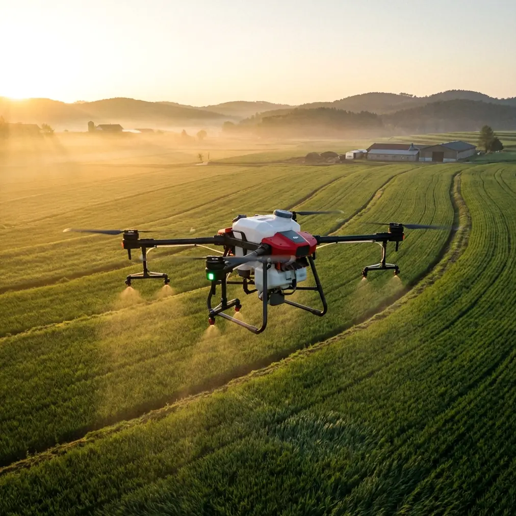
Highway corridors are unforgiving places to fly. Heat radiates off asphalt in waves. Winter air strips battery performance. Crosswinds curl around embankments, barriers, and passing trucks. If you are trying to document, map, inspect, or treat roadside vegetation with an Agras T70P in those conditions, the aircraft itself is only part of the answer. The real result comes from how you configure the system for temperature stress, wind behavior, positioning confidence, and payload consistency.
That is where the Agras T70P becomes interesting.
Most discussions around this platform stay too broad. They focus on headline capability instead of field behavior. For highway operations in extreme temperatures, what matters is whether the aircraft can keep a stable path along long linear assets, whether the spray pattern or imaging geometry stays consistent as air density changes, and whether the pilot can trust the positioning stack when working next to metal guardrails, bridges, signs, and moving traffic. Those are not abstract concerns. They shape whether a mission produces usable data or wasted flight time.
As an operator, I would approach the T70P as a corridor specialist rather than simply a large agricultural drone. That shift in mindset changes setup decisions immediately.
Start with the mission geometry, not the aircraft
Highways are long, narrow, and repetitive. That sounds simple until you account for interchanges, medians, drainage edges, utility poles, gantries, and traffic-induced turbulence. A broad-acre flight template rarely translates cleanly. The first operational discipline is to design the mission around swath control and overlap management.
If your objective is roadside vegetation treatment, swath width is the first number that deserves scrutiny. Too aggressive, and you increase spray drift near active lanes or neighboring land. Too narrow, and productivity falls off a cliff. In extreme heat, evaporative loss changes droplet behavior fast, especially above sun-soaked pavement. In colder conditions, atomization can shift and fluid viscosity becomes a more practical concern than many crews expect.
That is why nozzle calibration should not be treated as a one-time bench exercise. On the T70P, calibration discipline is operational risk management. If you tune in cool morning conditions and then keep flying into midday highway heat, your flow consistency and droplet profile may no longer match what you planned. The result can be under-application on one pass and drift-prone fines on the next.
My recommendation is blunt: recalibrate when ambient conditions materially change, and verify again after long transit segments between sites. Highway work exaggerates environmental swings because one corridor section may be shaded by cut slopes while the next reflects heat like a griddle. The aircraft can hold the path, but the liquid behavior may not hold the pattern.
RTK performance matters more than many crews admit
For corridor work, RTK fix rate is not just a nice-to-have metric. It is the foundation of repeatability. The T70P’s value rises sharply when you can trust centimeter precision over long, narrow routes. That matters for two different reasons.
First, it improves lane-edge and shoulder consistency when flying repeated passes. If your aircraft drifts a little farther outward on each leg, the error compounds. Near highways, small positional slop becomes a real safety and quality issue. You may overshoot a verge, miss a narrow strip, or produce uneven overlap in a data collection mission.
Second, repeatable RTK performance makes return missions credible. That is especially useful for highway agencies or contractors documenting the same sections across seasonal changes. If you are comparing vegetation encroachment, erosion development, or treatment effectiveness, you need the aircraft to revisit the corridor with near-identical geometry. “Close enough” is usually not enough.
This is where operators should watch the RTK fix rate continuously instead of merely confirming lock at launch. Highway environments are cluttered with reflective surfaces and partial obstructions. Bridges, overpasses, sound walls, and large sign structures can degrade confidence in ways that are intermittent rather than obvious. A momentary drop in fix quality may not trigger immediate alarm, but it can show up later as uneven line tracking or messy data registration.
For extreme-temperature missions, this gets harder. Heat shimmer can complicate visual interpretation and pilot judgment. Cold can compress battery margins and shorten the time available to recover from a degraded positioning event. The right habit is to build your route around known RTK-challenging segments and inspect those logs afterward. If a corridor consistently produces weak fix performance near certain structures, split the mission and adjust altitude or route geometry rather than pretending the problem is random.
Use the T70P’s weather resistance intelligently
One detail that deserves more respect is IPX6K protection. That rating does not make the aircraft invincible, but in dirty, wet, roadside environments it matters. Highway work exposes drones to more than temperature extremes. There is dust from shoulders, mist from traffic, residue from de-icing materials, and occasional washdown-style contamination after weather events. An IPX6K-rated platform is simply better aligned with that reality than a drone designed only for cleaner farm conditions.
Operationally, the significance is twofold.
First, cleanup and turnaround become more practical. If you are flying multiple corridor sections in one day, contamination control is not a cosmetic issue. Deposits on the airframe, spray system, and sensors can slowly degrade performance or reliability. A more wash-resistant system gives crews a realistic maintenance rhythm between sorties.
Second, that environmental resilience gives planners more confidence during shoulder-season deployments. A hot, dusty afternoon can be as punishing as freezing dawn moisture. The T70P’s protection profile supports work in those edge cases, provided crews still manage batteries, connectors, and payload hardware conservatively.
That last point is worth underlining. Airframe protection does not cancel the effect of temperature on power systems. In very low temperatures, flight planning should assume shorter useful endurance and slower battery behavior. In very high temperatures, charging and turnaround discipline matter just as much as airborne performance. A robust aircraft still fails operationally if the support cycle is sloppy.
Spray drift near highways is not a side issue
If the mission involves treatment rather than imaging, spray drift becomes the central hazard. Near highways, drift is not only an efficiency problem. It can cross into traffic exposure, non-target deposition, and public complaint territory very quickly.
The T70P can be a capable corridor treatment platform, but only when operators take droplet management seriously. Wind over pavement behaves differently than wind over crop canopy. It accelerates, swirls, and rebounds around barriers. Add thermal uplift from dark road surfaces and you have a recipe for lateral movement that basic field assumptions often miss.
The practical response is to treat nozzle selection, pressure settings, and flight timing as a single system. Early morning is often attractive, but highway air patterns can still be unstable near embankments and culverts. Midday may give better visibility but stronger thermals. There is no universal best slot. The right choice depends on whether your priority is droplet stability, traffic separation, or image clarity.
This is also the moment where a good third-party accessory can earn its place. On one corridor project, a compact third-party weather meter mounted in the field kit changed decision-making more than any app screen did. Real-time readings for crosswind and temperature differential helped the crew tighten go/no-go calls before drift became visible. That sounds small, yet it affected every pass. Not every accessory deserves to travel with the aircraft. A reliable environmental meter does.
If you need a practical checklist or want to compare corridor workflows with another operator, I suggest sending your field questions through this direct project chat. It is a cleaner way to resolve setup details than trying to improvise at the roadside.
Multispectral thinking can improve highway outcomes
Even if the immediate task is not classic agricultural analysis, multispectral workflow logic still has a place around highways. Many corridor missions are really about vegetation condition, moisture stress, invasive growth, or treatment verification. Standard RGB imagery tells part of the story. It rarely tells the whole one.
The T70P is not usually framed first as a multispectral platform in everyday conversation, but the concept matters here because highway vegetation management increasingly depends on distinguishing live growth patterns, stress zones, and regrowth potential along linear infrastructure. If you integrate a compatible sensing workflow into mission planning, you gain a stronger basis for deciding where treatment is necessary and where it is not.
That matters in extreme temperatures because heat stress and cold injury can make vegetation appear similar to the naked eye while behaving very differently in follow-up weeks. A corridor that looks uniformly stressed in visible imagery may contain patches with very different recovery profiles. Better sensing means better targeting, and better targeting means fewer unnecessary passes.
The key is not to oversell the technology. Multispectral-derived interpretation is only valuable if your route repeatability is strong and your geospatial alignment is trustworthy. That brings us back to RTK. Without consistent positioning, the analysis becomes less defensible over time.
A field workflow that fits the T70P
For crews planning real highway operations, I recommend a disciplined sequence:
Begin with a thermal reality check. Measure actual surface and ambient conditions, not just forecast temperature. Asphalt heat load can make flight behavior and fluid behavior diverge from what the morning briefing suggested.
Confirm RTK health before liftoff and during the first corridor leg. Do not assume one clean lock means a clean mission. Watch how the aircraft behaves near overhead structures, signs, and barriers.
Validate nozzle calibration in the conditions you are actually flying. If temperature or fluid behavior has changed, recalibrate. This is not wasted time. It is the difference between repeatable application and guesswork.
Set swath width conservatively for the first passes. Highway shoulders and medians leave little room for optimistic settings. Expand only after you see stable coverage and acceptable drift behavior.
Use the IPX6K advantage for maintenance discipline, not bravado. Clean down contamination, inspect connectors, and reset the aircraft for the next segment. Environmental durability is an asset only when paired with good ground habits.
Finally, document every anomaly. Extreme-temperature work punishes vague memory. If a specific interchange caused degraded fix rate or a certain cut section amplified drift, log it. The next mission gets better only if the crew carries forward what the corridor taught them.
Why the T70P fits this niche
The Agras T70P is not valuable for highway work merely because it is powerful. Plenty of platforms are powerful. Its practical fit comes from the combination of corridor-friendly precision expectations, ruggedized environmental tolerance such as IPX6K, and the ability to support disciplined application or repeatable route execution when the operator respects the limits of temperature, wind, and route complexity.
That last part is where many deployments either succeed or quietly disappoint. The aircraft can deliver centimeter precision, but only if the RTK environment supports it and the crew watches fix quality as a live operational variable. It can maintain productive treatment passes, but only if nozzle calibration keeps pace with thermal change and spray drift is managed as a dynamic risk, not a checkbox. It can endure rough roadside conditions, but only if the team treats ruggedness as support for better procedure rather than permission to get careless.
For highway capture in extreme temperatures, that is the real story. The T70P is not a shortcut. It is a capable platform that rewards disciplined setup, careful environmental reading, and route design built around the corridor instead of imposed on it.
Used that way, it becomes far more than an agricultural drone crossing into adjacent work. It becomes a serious tool for one of the most demanding low-altitude operating environments crews face.
Ready for your own Agras T70P? Contact our team for expert consultation.