Agras T70P for Coastal Construction Site Capture
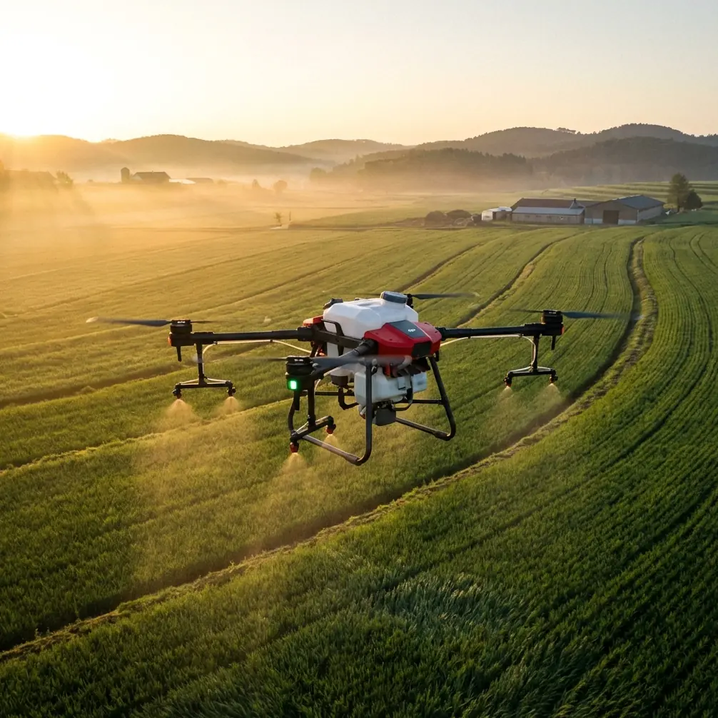
Agras T70P for Coastal Construction Site Capture: A Field Method That Holds Up When the Weather Turns
META: Practical expert guide to using the Agras T70P around coastal construction sites, with workflow advice on obstacle sensing, flight stability, RTK precision, spray drift awareness, and mid-flight weather changes.
Most people looking at the Agras T70P through an agriculture lens miss something useful: the same traits that matter over orchards and field edges also matter on a coastal construction site. Low-altitude control. Reliable obstacle awareness. Predictable path execution. The ability to keep doing precise work when the environment stops being polite.
That matters because coastal jobsites are rarely stable. Wind shifts off the water. Moisture creeps into everything. Temporary structures appear between one visit and the next. Dust, glare, puddling, stacked materials, cranes, fencing, and uneven ground all change what “routine flight” really means. If you are capturing progress, documenting drainage patterns, checking perimeter conditions, or building repeatable visual records across multiple phases, the Agras T70P has to be approached as a serious low-altitude work platform, not just a drone with a camera attached.
This guide is built around one idea: if you want dependable site capture from an Agras T70P in coastal conditions, your workflow has to respect sensor behavior, flight geometry, and weather response from the first minute.
Why obstacle sensing deserves more attention than the spec sheet headline
One of the most practical reference points comes from DJI educational material explaining TOF sensing. The core principle is simple: a Time of Flight sensor measures distance by sending out infrared light and timing how long it takes to return. The source even spells out the physics plainly: distance equals speed times time, with light traveling at roughly 3 × 10^8 meters per second.
That sounds academic until you are flying near concrete forms, rebar cages, site trailers, seawalls, retaining structures, and newly erected frames.
On a coastal construction site, the useful takeaway is this: your drone’s obstacle awareness is not “magic avoidance.” It is a distance-estimation process that becomes most valuable during takeoff, landing, and low-altitude flight—exactly the phases where construction capture often becomes messy. The training document specifically points out that drones in autonomous operations face obstacles such as trees, buildings, hills, and cliffs, and may need to route around them, hover, or back away to avoid collision. Translate that to your site and the equivalents are obvious: scaffolding, light poles, stored pipe, container stacks, embankments, berms, and unfinished vertical elements.
For Agras T70P operators, this means two things operationally:
- Do not treat low-altitude passes as a minor part of the mission. They are where obstacle sensing earns its keep.
- Re-check site geometry every visit. A route that was clean three days ago may now have a pump line, portable office, or lift parked right in the flight corridor.
If your capture plan includes perimeter runs or repeated passes over drainage features, use conservative spacing near new structures rather than assuming yesterday’s map still reflects today’s risk.
Repeatable path geometry is not just neat flying—it is data discipline
Another overlooked lesson from the reference material is the training emphasis on controlled circular paths: 5 counterclockwise circles, then 9-circle tracking with real-time lap display, and even 3 spiral ascent loops. At first glance, those are educational exercises. In practice, they point to something construction teams often undervalue: repeatable geometry.
Agras T70P capture becomes more useful when your flight path is intentionally repeatable. On a coastal site, that means:
- repeating the same perimeter orbit around a building pad,
- using a fixed-radius loop around a retention pond or shoreline edge,
- performing a consistent ascending pass over a staging area,
- documenting vertical progress from the same arc and altitude each visit.
Why does this matter? Because consistent geometry makes change visible. If the drone flies the same circular or arc-based route each time, you can compare stockpile growth, erosion patterns, water intrusion, traffic routes, and facade progress without the “operator style” changing the story.
The training document’s multi-circle exercises are useful here because they reinforce how a drone behaves when orientation changes. One mode keeps the aircraft facing the direction of travel. Another keeps it oriented toward the circle center while moving in a roll-based path. On a real site, that distinction affects camera framing, side-obstacle awareness, and the readability of your footage. If your goal is construction documentation rather than visual flair, stable orientation logic matters more than dramatic movement.
My advice: create two standard capture patterns for the Agras T70P on coastal jobsites.
- Pattern A: low perimeter documentation run for fencing, drainage channels, seawalls, access roads, and material laydown zones.
- Pattern B: elevated orbit or spiral overview for structural progress and broader context.
That second pattern mirrors the spiral ascent training concept. It is particularly useful when you want a single, readable sequence showing how a site relates to shoreline, adjacent access roads, and active work zones.
What happened when the weather shifted mid-flight
A coastal site rarely gives you a fully predictable weather window. One of the most instructive field situations I have seen started as a calm progress-capture mission and changed halfway through. The first segment was straightforward: light breeze, stable horizon, clean visibility over the graded section near the water-facing edge. Then the wind rotated.
Not a dramatic storm. Just enough of a change to matter.
The incoming air off the coast sharpened the gust pattern and kicked fine moisture across the site. You could see it immediately in the behavior of loose dust and standing water ripple lines. That is exactly the moment when a sloppy operator keeps pushing the original plan. A disciplined one starts editing.
With the Agras T70P, the right response is not panic. It is task triage.
First, shorten the low pass nearest exposed vertical obstacles. Gusts close to incomplete structural edges or temporary barriers can create ugly lateral corrections. Second, prioritize the sections of the route that still deliver usable documentation without forcing the aircraft into the site’s most turbulent corridor. Third, keep your orientation and speed consistent enough that the footage remains comparable to previous site records.
This is where the broader drone references become surprisingly relevant. The dronelife report on Otto Aerospace’s unmanned laminar-flow drone focused on validation of a low-drag airframe during a flight-test campaign at Spaceport America in New Mexico, in support of DARPA’s Energy Web Aircraft program. That aircraft is obviously from a different class and mission profile than the Agras T70P. But the engineering lesson carries over: aerodynamic efficiency and airframe behavior are not abstract benefits. They determine how cleanly a platform moves through disturbed air.
For a construction operator, that matters in a simpler way. When the weather changes mid-flight, you need a drone that remains predictable enough for you to revise the mission rather than abort from confusion. Stable path discipline, sensible obstacle margins, and consistent control inputs matter more than heroic flying.
On the day I’m describing, the mission was not abandoned. It was narrowed. The offshore-facing edge was documented from a safer offset, the higher orbit was completed, and the most turbulence-prone low sweep near stacked formwork was deferred. The result was still useful, because the operator treated the weather shift as a documentation problem to manage, not a challenge to overcome theatrically.
RTK fix rate and centimeter precision only help if your route logic is sound
Construction professionals love the idea of centimeter precision. They should. On coastal jobsites, small deviations matter. A few centimeters can change how you read drainage slopes, utility trench alignment, edge protection placement, and repeated progress viewpoints.
But RTK fix rate and centimeter precision are not substitutes for judgment.
If you fly inconsistent tracks, vary your altitude from habit rather than plan, or improvise around obstacles each visit without logging those changes, precise positioning will not rescue the usefulness of your output. It will simply make your inconsistency more precisely repeatable.
Here is the practical hierarchy I recommend for Agras T70P site capture:
- Safe route design
- Consistent flight geometry
- Obstacle-aware low-altitude execution
- RTK-supported precision
- Clean visual capture settings
In other words, the fix rate matters after the route makes sense.
For coastal projects, that often means choosing reference lines that survive site evolution. Perimeter roads, seawall edges, drainage ditches, and fixed utility corridors usually outlast temporary staging arrangements. Build your repeated capture plan around those stable anchors.
Why spray-drift thinking still applies on a construction site
Even though the Agras T70P is associated with agricultural work, concepts like spray drift and nozzle calibration still have value as mental models on a coastal construction mission.
Not because you are spraying a construction site. Because those concepts train operators to think carefully about airflow, distribution, and environmental influence.
Spray drift awareness teaches you to respect crosswinds and microclimates. On a coastal site, that same awareness helps you recognize where air behaves differently:
- along retaining walls,
- near open water,
- between container rows,
- beside unfinished facades,
- over heated ground surfaces beside damp zones.
Nozzle calibration, similarly, is about controlled output and repeatable delivery. Applied to capture work, the equivalent is camera consistency and path regularity. You want the drone to “deliver” the same observational result each time. Same corridor. Same offset. Same altitude band. Same angle where possible.
That is how a weekly site archive becomes operationally useful rather than just visually interesting.
Sensor planning at takeoff and landing is where jobs are won or lost
The training material on TOF sensing emphasizes that obstacle problems are especially common during takeoff, landing, and low-altitude flight. I agree with that completely, and on coastal construction sites I would put extra emphasis on launch and recovery zones.
These are the common traps:
- launching too close to fencing or stacked materials,
- landing near reflective puddles or uneven fill,
- setting up in a corridor where trucks or personnel movement interrupts recovery,
- underestimating how quickly wind direction changes at ground level near structures.
If the Agras T70P is going to work smoothly, the landing area should be treated as a controlled workspace, not an afterthought. You want a buffer clear of loose debris, a reliable visual line for descent, and enough separation from vertical clutter that the aircraft’s avoidance logic is helping rather than constantly intervening.
A lot of poor “drone performance” stories are really launch-site planning failures.
Long-endurance thinking without pretending this is a fixed-wing mission
The MIT “Jungle Hawk” reference describes a very different drone, but it contains one useful strategic idea for commercial UAV work: endurance only matters if it serves the mission. That aircraft reportedly flew for 5 days at 15,000 feet (4,500 meters) while carrying 10 to 20 pounds of payload, and the project team chose gasoline partly because solar limitations tied performance to season and latitude.
No, the Agras T70P is not that kind of aircraft. But the lesson is relevant to construction operators who obsess over maximum sortie time. On a coastal jobsite, the more useful question is not “How long can I stay up?” It is “Can I complete the right capture sequence before conditions or site movement make the data less reliable?”
That mindset usually leads to better missions:
- shorter but more repeatable routes,
- cleaner sequencing,
- faster adaptation when wind or moisture changes,
- less wasted battery on decorative flight.
Endurance is helpful. Mission discipline is better.
A practical capture workflow for the Agras T70P on a coastal project
Here is the method I recommend.
1. Walk the site before powering up
Identify new verticals, temporary structures, pooled water, moving equipment, and likely gust corridors.
2. Define two route layers
Use one low-altitude path for perimeter and drainage capture. Use one elevated orbit or spiral route for overall progress context.
3. Validate your obstacle environment
Remember the TOF principle: the system is estimating distance through reflected infrared timing. Give it clear operational margins near clutter.
4. Lock repeatable geometry
If your route includes arcs or circles, keep them consistent. The educational reference uses 5-circle and 9-circle drills for a reason: repetition reveals control quality.
5. Watch the weather actively, not passively
If the wind rotates or moisture moves in, edit the mission. Do not force the original route just because it is already programmed.
6. Protect comparability
RTK precision is valuable, but only when your flight logic stays stable from visit to visit.
7. Debrief immediately
Note what changed: turbulence near the shoreline edge, poor visibility over standing water, new obstructions near access roads, or framing issues from altered orientation. Those notes improve the next mission far more than memory alone.
If you are building a repeatable capture workflow and want to compare route setups for your site, you can message Marcus directly here: share your flight scenario.
The real value of the Agras T70P in this setting
For coastal construction capture, the Agras T70P earns its place when it is used with discipline. Not because it can simply get airborne, but because it can operate in the exact band where site work becomes difficult: low altitude, changing obstacles, unstable wind, evolving terrain, and the constant need for repeatable documentation.
The references behind this article point to three operational truths:
- TOF sensing is most meaningful where collision risk is highest: low-level autonomous movement near obstacles.
- Repeatable circular and spiral path training is not academic; it builds the route consistency that serious documentation depends on.
- Airframe behavior and mission design matter when weather changes. A drone does not need to be exotic to benefit from aerodynamic discipline and smart in-flight adjustment.
That is the difference between random footage and a site record people can actually use.
Ready for your own Agras T70P? Contact our team for expert consultation.