Agras T70P on the Coastline: A Real-World Capture Strategy
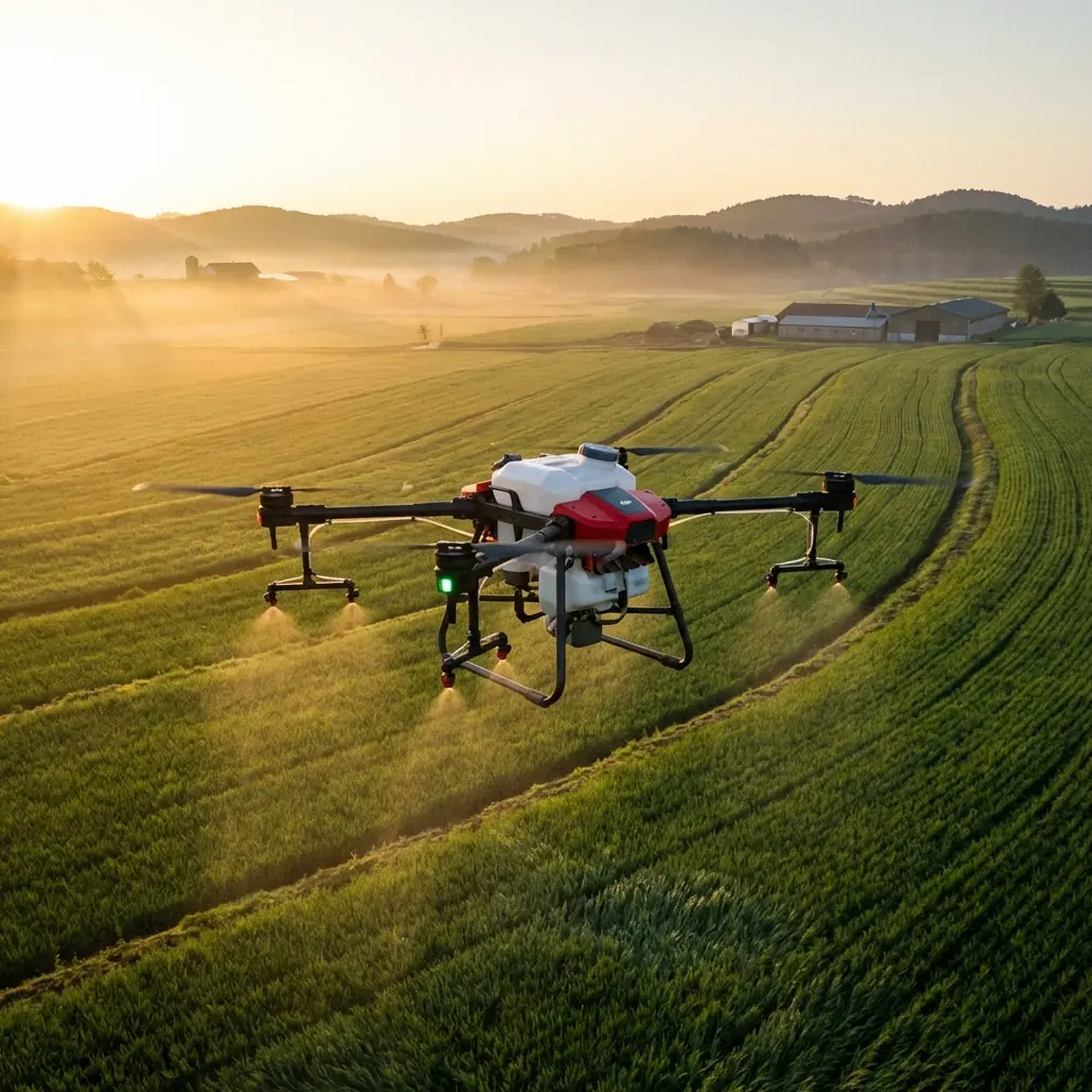
Agras T70P on the Coastline: A Real-World Capture Strategy for Urban Edge Work
META: A field-based Agras T70P case study for urban coastline operations, covering sensor awareness, RTK precision, spray drift control, nozzle calibration, and wet-environment reliability.
Urban coastline work exposes every weak point in a drone operation. Salt in the air. Gusts rebounding off glass and concrete. Narrow launch areas. Pedestrians, birds, utility lines, reflective water, and a shoreline that keeps changing character every few hundred meters. If someone wants to understand whether the Agras T70P is just a spec-sheet machine or a platform that can actually hold together in a difficult civilian mission, the coast is a good place to find out.
I approached this job as a consultant would: not as a flashy demo, but as a systems exercise. The assignment was to document a mixed-use urban shoreline where landscaped public zones met hard seawall infrastructure, drainage outfalls, service roads, and green strips under active maintenance. The client’s goal was broader than pretty imagery. They wanted repeatable capture, actionable site awareness, and a workflow that could support follow-up vegetation treatment planning without guessing. That is exactly where the Agras T70P becomes interesting.
The T70P is often discussed in agricultural terms, which is fair. But on a coastline in an urban setting, its value shows up in a different way. It is less about one isolated capability and more about how several operational traits stack together: stable positioning, reliable environmental protection, controlled application logic, and the ability to work near variable surfaces where precision matters more than raw speed.
The morning started before sunrise because coastal cities tend to offer their calmest air in a narrow window. That matters for any drone, but especially for missions where spray drift is part of the planning conversation. Even when the objective is capture and assessment first, the T70P is rarely used in a vacuum. It often feeds the next operational decision, whether that is targeted treatment, vegetation management, or maintenance scheduling. If drift is not understood during reconnaissance, the later application phase is already compromised.
The first operational check was not the camera feed. It was the RTK fix rate. On coastal edges bordered by buildings, retaining walls, and signal reflections off water, the difference between acceptable positioning and centimeter precision is the difference between a clean repeatable corridor and an inconsistent one. A stable RTK solution lets the operator fly the same line again under similar conditions, compare plant stress or ground changes, and keep swath width planning realistic instead of theoretical. For clients managing narrow bands of vegetation near public walkways, that repeatability is operationally significant. It reduces overlap waste, limits exposure to adjacent surfaces, and makes post-flight analysis more credible.
That sounds technical because it is technical. But the practical outcome is simple. When the aircraft knows exactly where it is, the work becomes calmer. The operator can focus on edge conditions instead of compensating for drift in the map itself.
On this site, those edge conditions changed constantly. One section of shoreline had low ornamental plantings beside a paved cycling path. Another opened onto rough grass and drainage channels. A third section sat below residential towers where wind behaved badly, shearing sideways before dropping toward the water. That is where swath width stops being a marketing term and becomes a field judgment. A wide pass only helps if it stays consistent. In urban coastal conditions, a disciplined swath width plan often outperforms an aggressive one because the real challenge is boundary control.
The Agras T70P handled that well, partly because setup discipline was built into the mission from the start. Nozzle calibration was not treated as a back-office detail. It was done with the shoreline environment in mind. Coastal operations complicate application behavior in ways inland crews sometimes underestimate. Fine droplets can migrate over hardscape, decorative stone, railings, or waterfront seating. They can also disappear into uneven wind layers that are hard to spot from the ground. Calibration, then, is not only about output accuracy. It is about matching the spray profile to an environment where public-facing surfaces sit right next to target vegetation. If the pattern is not tuned correctly, the mission may still look clean in logs while performing poorly in reality.
That distinction matters when the reader is evaluating whether the T70P fits coastal urban work. A capable platform does not remove the need for operator judgment; it rewards it. The T70P gives enough control for that judgment to matter.
Midway through the first corridor, the shoreline produced the kind of moment that reminds you why sensor awareness is not optional. A small group of egrets lifted from a tidal edge beside the stormwater outlet and crossed the intended route at low altitude. They had been difficult to pick out against the pale concrete and shimmering water until they moved. The aircraft’s sensors gave the operator enough situational warning to pause the line and hold position rather than forcing a rushed manual correction near a seawall. That short interruption did more than protect wildlife. It preserved mission quality. No hurried sidestep, no broken track, no sloppy restart.
This is one of the underappreciated strengths of using a platform like the T70P in mixed environments. Urban coastline jobs are not sterile. Wildlife, maintenance vehicles, joggers, service crews, and changing reflections all show up uninvited. A system that can navigate these interruptions without turning the flight into chaos is worth more than one that looks impressive only in open fields.
The wet side of the environment also deserves more respect than it usually gets. Coastline air is abrasive. Salt residue finds its way into places operators forget to inspect. Light rain or splashback from sea walls can arrive without warning when wakes hit the edge. An IPX6K rating is not a decorative spec in that context. It directly affects how confidently the aircraft can be staged, cleaned, and redeployed around moisture-heavy infrastructure. For teams working repeated shoreline segments over weeks or months, that durability matters because downtime rarely comes from a dramatic crash. It often comes from cumulative exposure and small failures that build from neglect.
In this case, the weather shifted faster than forecast. A low mist moved in from the harbor, and the crew had to decide whether to suspend the mission or continue with a shorter sequence focused on the most exposed edge. Because the aircraft was built for harsh working conditions, the decision centered on data quality and air movement rather than fear of basic environmental contact. That changes the whole tone of a job. The equipment stops dictating the mission. The mission dictates the equipment.
A second layer of value came from multispectral thinking, even where the client had originally framed the task as a visual capture exercise. Along urban shorelines, plant stress is easy to misread from standard imagery. Salt exposure, compacted soils, irrigation inconsistency, reflected heat from paving, and overspray from adjacent maintenance can produce symptoms that look similar from the ground. Integrating a multispectral workflow into planning gives the T70P a role beyond collection. It becomes part of a decision system for distinguishing turf decline from saline stress, or ornamental fatigue from drainage issues. That is useful when every maintenance decision near a public waterfront affects appearance, safety, and budget discipline.
This is where the article has to stay honest. The T70P does not magically solve interpretation problems. It gives the operator the precision and consistency needed to make comparisons meaningful. If the same coastline strip is captured with centimeter-level repeatability, operators can see whether decline patterns are stable, spreading, or tied to specific infrastructure zones. Without that consistency, every discussion about vegetation health becomes more subjective than it should be.
Another overlooked issue on coastline projects is launch and recovery geometry. Inland agricultural work often allows generous staging areas. Urban waterfronts do not. You get narrow service lay-bys, fenced maintenance strips, or small clearings between lamp posts and bollards. That compresses the safety envelope. Here again, platform stability and predictable positioning become practical, not abstract. The T70P’s value is that it can operate with discipline in constrained spaces as long as the crew respects the site. It does not make poor staging acceptable, but it does support more controlled handling in a setting where margins are thin.
The most successful part of this job was not a single flight segment. It was the integration of several small choices that compounded into a reliable outcome. The team monitored the RTK fix rate before committing to repeatable route work. They treated nozzle calibration as a frontline control for drift management rather than an afterthought. They kept swath width conservative near high-value public surfaces. They adjusted for moisture-heavy conditions instead of pretending the coast behaves like an inland farm. And when wildlife crossed the route, they let the sensors buy them time rather than improvising aggressively.
That is the right way to assess the Agras T70P for coastline operations in urban areas. Not by asking whether it can fly there. Plenty of drones can fly there. The better question is whether it can support disciplined, repeatable, low-drama work where every variable punishes carelessness. On that standard, the platform makes a serious case for itself.
The reference point that stayed with me from recent drone discussions was not about agriculture at all. A BBC report described how allied countries were asking Ukraine for help in countering drones, with President Volodymyr Zelensky remarking that it was a “good feeling” when partners sought that expertise. Strip away the military context, which is not relevant here, and one operational lesson still carries over: drone competence matters most when conditions are complex and consequences are real. Expertise is not the drone alone. It is the combination of platform capability, operator judgment, and disciplined process. On a civilian shoreline project, that same principle holds. The machine only delivers value if the team knows how to use precision, environmental resilience, and route control in a coordinated way.
For urban coastal asset managers, landscape teams, and contractors, that is the practical takeaway. The Agras T70P is not interesting because it promises perfection. It is interesting because it gives skilled crews a robust working envelope in one of the more awkward environments a civilian drone will face. Salt, moisture, variable wind, narrow corridors, living targets, hard boundaries, and public exposure all demand a platform that can keep its composure.
If you are planning a similar operation and want to compare site variables, flight logic, or calibration choices with someone who has worked through this kind of coastal workflow, start the conversation here: https://wa.me/85255379740
The shoreline job wrapped just as the harbor traffic picked up and the crosswind became annoying enough to end the session. We had what we needed: repeatable capture lines, cleaner edge awareness, a better understanding of where spray drift risk would rise later in the maintenance cycle, and a map of vegetation zones that deserved closer multispectral attention. That is what a good T70P mission looks like in the real world. Not theatrical. Useful.
Ready for your own Agras T70P? Contact our team for expert consultation.